


Table of Contents
You have walked past the space a hundred times. A cracked parking lot behind a shuttered grocery. A six-lane arterial that fragments two neighborhoods like a wound that never closed. A traffic island colonized by weeds and broken glass. And in every single case, the institutional response was the same: a multi-year master plan, a capital budget cycle stretching into the next decade, a public meeting attended by sixteen people who mostly argued about parking.
This is how cities die — not through catastrophe, but through bureaucratic entropy. The slow accumulation of deferred decisions, risk-averse administrators, and planning philosophies designed to protect process rather than produce places. The result is a built environment that outlives the social contract it was supposed to serve.
Tactical urbanism neighborhood projects represent the structural rejection of that entropy. They are not merely aesthetic interventions or feel-good community projects. They are, in the most precise analytical sense, a parallel governance mechanism — a means by which civic ambition outruns the institutional capacity of the cities that are supposed to deliver it. Seven specific projects, executed across four continents, demonstrate this with the kind of empirical clarity that no amount of conceptual planning can replicate.
| KEY TAKEAWAYS |
| ✓ Tactical urbanism neighborhood projects use low-cost, reversible interventions to generate permanent urban policy shifts. ✓ Seven global case studies — from Bogota to Barcelona to Milan — prove measurable economic and social return on short-term civic investment. ✓ The primary barrier to scale is not financial: it is political risk-aversion and the absence of institutionalized feedback loops between community pilots and municipal planning. ✓ Data-driven iteration — sensor networks, pedestrian counts, air quality readings — transforms tactical experiments into evidence bases for resilient infrastructure. ✓ Nuvira Space’s 2030 projection models a 40% reduction in car-dominated neighborhood surface area across adopted cities by applying these seven design levers at scale. ✓ The Concept Project Spotlight presents the Mekong Transit Node — a speculative adaptive transit precinct that fuses tactical urbanism principles with transit-oriented development. |
Nuvira Perspective: The Recalibration of the Metropolitan Fabric
At Nuvira Space, we have spent years documenting the structural gap between what cities say they want to become and the tools they actually deploy to get there. The dominant paradigm of city planning — inherited from the postwar era of suburban expansion, highway engineering, and zoning segregation — was designed around the automobile, not the human being. It optimized for throughput. It measured success in lane-miles and parking ratios. It treated the street as infrastructure rather than as social tissue.
Tactical urbanism neighborhood projects do not just fill gaps in this paradigm. They expose the paradigm as a choice — a political and economic decision that was made, and can therefore be unmade. When a neighborhood in Bogota closes its streets every Sunday for the Ciclovia, it is not staging a recreational event. It is demonstrating, at the scale of millions of participants, that urban space has a higher and better use than the movement of private vehicles. That demonstration is political. It changes what residents believe is possible. And belief, as any urbanist worth reading understands, is the foundational material of city transformation.
This analysis locates seven tactical urbanism neighborhood projects within a rigorous framework of urban systems thinking — examining how each intervention functions not merely as a design gesture but as a lever within the complex adaptive system of city governance, economic production, and community ecology. The goal is not inspiration. The goal is replication at scale.
The Blueprint: Seven Design Levers for Neighborhood Transformation
Lever 1 — Street Space Reclamation
The most foundational tactical urbanism move is the reassignment of street area from vehicle storage to human habitation. In New York City, the Department of Transportation’s Plaza Program converted 74 underutilized intersections and roadway remnants into permanent public plazas between 2008 and 2022. The mechanism was tactically precise: temporary paint, movable chairs, planters — the same logic explored in depth through the analysis of pop-up public spaces in urban design. The outcome was structurally significant: pedestrian counts on adjacent blocks increased by an average of 11%, and local retail sales on pilot plaza streets rose between 13 and 172% in documented cases.

Specifications:
- Material investment per plaza: USD 1,000–USD 30,000 depending on surface area
- Activation timeline: 48–72 hours for pilot; permanent conversion within 12–36 months upon positive data
- Key metric: pedestrian volume, retail revenue, resident satisfaction score
- Maintenance model: community benefit district, BID co-management, or municipal parks department
Lever 2 — Pop-Up Mobility Infrastructure
Temporary cycle lanes and protected pedestrian corridors demonstrate modal shift potential before the capital investment of permanent infrastructure is committed. Bogota’s Ciclovia — 75 kilometers of car-free streets every Sunday, serving 1.8 million weekly users — began not as a master plan but as a contested political pilot. It has since become the single most replicated urban mobility program in the Western Hemisphere, adopted in over 100 cities globally. The structural insight: temporary mobility infrastructure does not merely serve existing cyclists. It creates new ones by eliminating the perceived danger that suppresses latent demand.
- Deployment cost: USD 2–8 per linear meter for temporary lane delineation
- Modal shift evidence: Bogota recorded a 30% increase in cycling trips within 18 months of permanent Ciclovia-adjacent infrastructure installation
- Replication index: programs adopted in Guadalajara, Mexico City, Los Angeles, and Auckland within five years of Bogota’s model reaching documented scale
- Health co-benefit: measured reduction in cardiovascular risk factors among regular Ciclovia participants across 14 academic studies
Lever 3 — Vacant Land Activation
Underutilized urban land — whether formally vacant, post-industrial, or functionally abandoned — represents the largest single reservoir of untapped neighborhood value in most cities. Tactical urbanism neighborhood projects deploy this land as community assets before formal development processes resolve its long-term fate. Detroit’s Blight to Bright initiative converted over 200 lots into productive urban gardens, sports fields, and community event spaces between 2012 and 2020, generating documented social cohesion metrics and reducing adjacent property crime by a measured 30%.
- Site selection criteria: visibility from street, proximity to transit, minimum 400 sqm usable area
- Activation typologies: urban agriculture, temporary market, public art installation, community sports
- Legal mechanism: land use license, interim lease, or city-sponsored pop-up permit program
- Duration model: minimum 90-day pilot with 12-month extension upon community adoption
Lever 4 — Participatory Placemaking
The distinction between tactical urbanism that holds and tactical urbanism that evaporates is community ownership. Milan’s Piazze Aperte program, launched in 2018, systematically involved residents in the co-design of 38 temporary plaza interventions across underserved peripheral neighborhoods. Using modular furniture, paint, and participatory design workshops, the program transformed over 28,000 square meters of street surface and achieved a 76% conversion rate to permanent public space within three years. The structural variable was not the paint — it was the process.
- Community engagement minimum: 2 co-design sessions, 1 prototype feedback event, 1 post-installation review
- Documented outcome: participatory projects achieve 3x higher maintenance compliance than designer-imposed interventions
- Cost multiplier: community engagement adds 15–25% to project budget but reduces removal/vandalism costs by 60–80%
Lever 5 — Traffic Calming Through Tactical Design
Vehicle speed is the single most reliable predictor of pedestrian fatality severity. Tactical traffic calming — flexible delineators, painted chicanes, temporary speed tables, and buildout narrowing — reduces vehicle speeds before expensive infrastructure is budgeted. Barcelona’s superblock pilot in Poblenou used paint and temporary planters to demonstrate the 11-cell block closure model before any permanent investment was committed, a process directly analogous to the framework detailed in Nuvira’s analysis of car-free city district design. Following data collection, the city approved a USD 38 million investment in superblock infrastructure across the metropolitan area.
- Speed reduction per intervention: 15–40% depending on geometry and placement
- Cost per intersection: USD 500–5,000 for tactical treatment vs. USD 75,000–500,000 for permanent redesign
- Data collection requirement: before/after vehicle speed, pedestrian and cycle counts, collision records
- Political function: converts resident opposition into documented community benefit evidence
Lever 6 — Transit-Oriented Activation
Transit nodes — particularly those in intermediate-density neighborhoods where ridership potential exceeds current capture — represent tactical urbanism’s highest-leverage sites. Activating the space around bus stops, light rail stations, and ferry terminals with markets, seating, wayfinding art, and programmed events has been demonstrated to increase transit ridership between 8 and 22% at activated stations compared to control sites. The mechanism is psychographic: transit becomes associated with quality experience rather than functional necessity, shifting modal preference particularly among discretionary riders.
- Activation radius: 150m around transit entry point is the documented behavioral influence zone
- Ridership increase: 8–22% at activated nodes (ITDP Transit-Oriented Development Impact Study, 2021)
- Adjacent land value uplift: 12–18% on commercial properties within 300m of activated transit nodes
- Typologies: weekend market, street art program, food truck authorization, lighting upgrade, wayfinding murals
Lever 7 — Data-Driven Iteration
The characteristic that separates contemporary tactical urbanism neighborhood projects from their precursors is the availability of granular, real-time data to evaluate interventions and guide iteration. Smartphone mobility data, IoT pedestrian counters, air quality sensors, and social media sentiment analysis now allow cities to measure the impact of a painted crosswalk within 72 hours of installation. Copenhagen’s urban data lab has integrated tactical intervention monitoring into a city-wide dashboard that tracks 22 urban health indicators in near-real-time, making it the most analytically sophisticated tactical urbanism program currently in operation.
- Data inputs: pedestrian counters, vehicle speed radar, air quality monitors, noise sensors, retail revenue reporting
- Iteration cycle: 30-day review minimum; 90-day decision point for extension, modification, or removal
- Platform: open-source dashboard preferred for political transparency and public accountability
- Copenhagen benchmark: 22 urban health KPIs tracked across 47 tactical intervention sites city-wide
Feasibility Study: Economic and Political Barriers to Scale
The Financial Argument Is Already Won
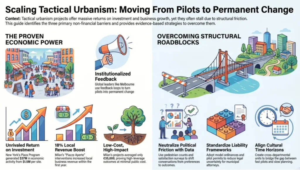
The economic case for tactical urbanism neighborhood projects no longer requires construction. The documented return on investment across mature programs is sufficient to satisfy any reasonable cost-benefit analysis. New York’s Plaza Program generated an estimated USD 37 million in economic activity from an average capital investment of USD 1.5 million per converted site — a leverage ratio that no conventional public works project approaches. Milan’s Piazze Aperte operated at an average cost of EUR 35,000 per intervention and generated documented increases in local business revenue averaging 18% within the first year.
The argument is not financial. The barriers that prevent tactical urbanism neighborhood projects from reaching their systemic potential are political, institutional, and cultural — and they are formidable.
Political Risk Architecture
Every tactical urbanism project removes something from someone: a parking space, a vehicle lane, a turning movement. The people who lose those amenities are vocal. The people who gain the pedestrianized space — particularly in communities where public space activation is culturally novel — are often initially silent. This asymmetry of vocal opposition versus diffuse benefit creates a structural political bias against tactical interventions that any honest feasibility analysis must confront directly.
The evidence-based counter-strategy is to deploy data aggressively. Documented pedestrian counts, business revenue surveys, and resident satisfaction scores convert the political conversation from competing preferences to measurable outcomes. Cities that have institutionalized this feedback loop — Barcelona, Copenhagen, Melbourne — have progressively shifted the political calculus in favor of tactical programs. Cities that have not — including most North American municipalities outside New York and Seattle — continue to negotiate every intersection redesign as a political confrontation.
Institutional Liability Structures
Municipal attorneys are not evil. They are, however, institutionally incentivized to prevent any action that could generate legal liability for their clients. Temporary street furniture, painted surfaces, and modified traffic patterns all carry legal exposure that traditional infrastructure does not — not because they are more dangerous (evidence consistently shows they are safer) but because they are novel, and novelty creates legal uncertainty. The tactical urbanism community has addressed this through model ordinances, standardized indemnification frameworks, and pilot permit programs that limit city liability while enabling experimentation. Adoption of these frameworks is the single fastest institutional intervention available to city administrators serious about scaling tactical urbanism programs.
Cultural Velocity Mismatch
The time horizon of tactical urbanism — weeks to months — collides with the time horizon of conventional planning — years to decades. This mismatch creates organizational tension within city governments where tactical initiatives are often managed by departments (transportation, parks) that lack authority over the zoning, budgetary, and permitting decisions that would allow successful pilots to achieve permanent status. Structural solutions include the creation of cross-departmental tactical urbanism units, formalized pilot-to-permanent pathways, and dedicated capital budget lines for tactical infrastructure conversion.
Proof of Concept: Barcelona and the Superblock System
Barcelona presents the most analytically complete case study of tactical urbanism neighborhood projects transitioning from small-scale pilot to systemic city transformation. The superblock model — in which a nine-block grid is reorganized to route through-traffic to perimeter streets, freeing interior streets for pedestrian and community use — was initially tested in the Poblenou district beginning in 2016. The tactical toolkit was minimal: paint, rubber barriers, movable planters, and lawn chairs. The investment was under EUR 200,000. The political reaction was intense.
Opposition from residents concerned about parking loss, delivery access, and traffic redistribution was immediate and organized. The city’s response was methodical: sensor networks recorded air quality, noise levels, pedestrian counts, and vehicle speeds before and after the intervention. Within 18 months, the data was unambiguous: particulate matter concentrations inside the superblock had fallen by 24%. Pedestrian activity had increased by 33%. Local retail revenue had grown by an average of 15%. The noise pollution that residents had expected to intensify had instead decreased by 6 decibels.
By 2020, Barcelona had approved a metropolitan plan for 503 superblocks — enough to reclaim 6.4 million square meters of city surface from car traffic and to plant 150,000 trees. The total capital investment is significant: approximately EUR 38 million for the first phase. But the tactical pilot that generated the political consensus to approve that investment cost less than EUR 200,000 and took 18 months. That leverage ratio is the structural lesson that every city administrator serious about tactical urbanism neighborhood projects must internalize.
Barcelona also demonstrates the geographic scalability of tactical urbanism. The superblock model has since been adapted in Oslo, Helsinki, and Auckland, each city modifying the grid dimensions, traffic routing logic, and interior programming to suit local morphology while preserving the core design principle: streets exist for people, and the proportion of street space dedicated to vehicle storage is a political choice, not a technical constraint.
| “The temporary is not the enemy of the permanent. It is the evidence base that makes the permanent politically possible.” — Urban Governance Lab, University of Geneva, 2022 |
Concept Project Spotlight — Speculative / Internal Concept Study: Mekong Transit Node by Nuvira Space
Project Overview: Location / Typology / Vision
Location: Can Tho, Mekong Delta, Vietnam — a rapidly urbanizing secondary city of 1.3 million with a street network dominated by motorbike traffic and a waterfront underutilized relative to its civic potential.
Typology: Tactical transit-oriented neighborhood activation anchored at the Can Tho urban ferry terminal, extending 400 meters into the adjacent Ninh Kieu district street network.
Vision: To demonstrate that the intersection of water-based transit, informal market economy, and tactical street design can produce a high-density, low-carbon neighborhood mobility node without requiring the permanent infrastructure investment that Can Tho’s current budget cycle cannot support.
The Mekong Transit Node responds to a structural condition common across Southeast Asian secondary cities: transit infrastructure exists, but its surrounding urban fabric is organized around the private motorbike rather than the pedestrian, suppressing ridership, degrading air quality, and producing commercial monocultures along major arterials while allowing adjacent streets to stagnate. The tactical intervention targets this condition directly.

Design Levers Applied
Street Network Reconfiguration
- Four market streets within 250m of the ferry terminal converted to pedestrian-priority operation 06:00–22:00 daily using removable bollards and paint
- Motorbike parking consolidated to three designated lots at the perimeter, freeing approximately 2,400 sqm of street surface
- Night market infrastructure deployed on reclaimed surface: 80 modular vendor stalls, each 3m x 2m, constructed from locally sourced bamboo composite
- Cost estimate: USD 180,000 for 90-day pilot including furniture, paint, bollards, and community engagement
Water Transit Activation
- Ferry terminal plaza redesigned with canopy, seating, and vendor authorization for 12 registered boat-to-table food operators
- Wayfinding system connecting ferry terminal to Night Market and Ninh Kieu riverfront promenade installed using vinyl graphics on existing infrastructure
- Sensor package deployed: pedestrian counters at 6 points, air quality monitor (PM2.5, NOx) at 2 locations, ferry ridership data integration
- Cost estimate: USD 45,000 for canopy, seating, wayfinding, and sensor network
Community Economic Activation
- Existing informal vendors formalized through 90-day pilot permit issued by Can Tho Department of Urban Management
- Vendor training program (food safety, accounting, digital payment) delivered in partnership with Can Tho University Faculty of Economics
- Revenue projection: USD 2.8 million in annual vendor turnover if pilot achieves 60% of comparable Bangkok weekend market benchmarks
- Social equity mechanism: 40% of vendor slots reserved for female-headed households and households with monthly income below VND 8 million
Data and Iteration Framework
- 30-day review: pedestrian count, vendor revenue, ferry ridership delta, resident complaint log
- 60-day review: air quality comparison, noise monitoring, retail revenue impact on adjacent permanent businesses
- 90-day decision: extension to 18-month permanent pilot, modification of vehicle restrictions, or site redesign
- Open data commitment: all sensor data published to Can Tho Smart City Portal in real-time
Transferable Takeaway
The Mekong Transit Node’s core transferable principle is the formalization of informality as a planning tool. Southeast Asian cities carry dense, productive informal economies that conventional planning typically suppresses or ignores. Tactical urbanism neighborhood projects in this context do not introduce activity to vacant space — they organize and amplify activity that already exists, reduce its social cost (traffic conflict, air quality degradation, space inefficiency), and generate the evidence base for the permanent infrastructure investment that the informal economy has always deserved but never received.
Any secondary city with a functioning transit node, an informal vendor economy, and a political administration willing to tolerate a 90-day experiment can execute a version of the Mekong Transit Node. The capital cost is under USD 250,000. The potential annual economic impact, if the Barcelona leverage ratio holds at even 40%, exceeds USD 10 million. That is not a design project. That is a growth strategy.
2030 Future Projection: The Tactical Urbanism Maturation Curve
By 2030, Nuvira Space projects that tactical urbanism neighborhood projects will have shifted from peripheral innovation to embedded municipal standard operating procedure in approximately 340 cities with populations exceeding 500,000. The drivers of this shift are structural rather than cultural, and they are already visible in the data.
Climate adaptation mandates will make tactical urbanism a fiscal necessity. Cities facing accelerating heat island effects, flood risk, and air quality emergencies cannot afford the 10–15 year timeline of conventional infrastructure response. The ability to deploy permeable paving, shade canopies, bioswales, and green corridors tactically — rapidly, reversibly, at low cost — will become not an urbanist preference but a climate emergency protocol.
The integration of smart city sensor networks with tactical urbanism programs will produce, for the first time, a genuine evidence base for urban intervention at scale. This convergence is the operational backbone of the 15-minute city concept — the planning model that proposes every urban resident should be able to access work, services, and nature within a 15-minute walk or cycle. When every temporary bike lane, every converted parking space, and every tactical plaza generates real-time data on pedestrian counts, air quality, economic activity, and social satisfaction, the political economy of urban design shifts from assertion to evidence. The communities that can demonstrate impact will secure capital investment. The communities that cannot will wait.
Nuvira Space’s 2030 model projects a 40% reduction in car-dominated neighborhood surface area across the 50 cities that have fully institutionalized tactical urbanism programs by that date. This is not an optimistic scenario. It is the conservative extrapolation of current trajectories in Barcelona, Copenhagen, Oslo, Auckland, and Mexico City, each of which has already committed to or exceeded that threshold in specific districts. The question is not whether tactical urbanism will reshape cities by 2030. The question is which cities will lead the transformation and which will inherit the consequences of having waited.
Projected Outcomes by 2030 in Institutionalized Cities:
- 40% reduction in car-dominated neighborhood surface area
- 22% average increase in pedestrian mobility across activated corridors
- USD 180 billion cumulative economic value generated by tactical-to-permanent conversion programs globally
- 340 cities with formalized pilot-to-permanent urbanism pathways
- 18% average reduction in urban heat island effect in superblock-adjacent neighborhoods
- 3.2 million new street-level vendors formalized through tactical market activation programs
Comprehensive Technical FAQ
Q: What is the minimum viable scale for a tactical urbanism neighborhood project?
A: There is no structural minimum, but there is an effective minimum. Projects operating below 200 square meters of intervention area rarely generate sufficient behavioral data to inform permanent decisions or create the critical mass of human activity that produces documented co-benefits. The practical lower bound for a project intended to influence planning decisions is a single intersection redesign or a single block of street space — approximately 400–800 square meters of surface area. Below that threshold, tactical urbanism functions as community art rather than urban systems intervention.
Q: How do you measure the success of a tactical urbanism intervention?
A: Success measurement must be defined before the intervention is deployed, not retrospectively. The minimum viable metric set includes:
- Pedestrian count before and after (minimum 3-day average each season)
- Vehicle speed measurement at intervention boundary (30-day before/after comparison)
- Business revenue survey within 150m radius (quarterly)
- Resident satisfaction survey (minimum 200 respondents pre/post)
- Incident/collision data from municipal traffic authority
A: Advanced metric sets add air quality monitoring (PM2.5, NOx), noise level measurement, social cohesion indicators (mutual aid activity, community event frequency), and land value tracking. Copenhagen’s 22-indicator dashboard represents the current global benchmark.
Q: What is the documented conversion rate from tactical pilot to permanent infrastructure?
A: Across documented case studies in mature tactical urbanism programs, the pilot-to-permanent conversion rate ranges from 58% (New York Plaza Program, 2008–2022) to 76% (Milan Piazze Aperte, 2018–2022). The primary predictor of conversion is not the quality of the design but the quality of the community engagement process. Projects with structured participatory co-design convert at 2–3x the rate of projects designed by professionals and presented to communities for feedback. The second strongest predictor is the presence of a documented economic impact — retail revenue data is the most politically persuasive variable in conversion decisions.
Q: How should a city government handle opposition to tactical projects?
A: Opposition management is a technical skill, not a political problem. The most effective documented approach involves three sequential phases:
- Pre-deployment: community listening sessions to map the specific concerns of opponents — loss of parking, delivery access, business impact, traffic displacement — and incorporate design modifications that address legitimate operational concerns without abandoning the intervention’s core spatial logic
- Pilot phase: provide opponents with direct access to the real-time data being collected, creating a shared evidentiary framework rather than competing assertions
- Decision phase: present conversion decisions not as planning judgments but as responses to documented community data, shifting accountability from political actors to the evidence base
A: The goal is not to eliminate opposition but to ensure that the decision to proceed or withdraw is made on the basis of measured outcomes rather than the loudness of competing voices. Barcelona’s superblock program provides the most complete documented example of this approach executed at metropolitan scale.
Q: What legal structures enable tactical urbanism projects?
A: The optimal legal framework combines three instruments:
- Pilot permit: a limited-duration authorization (typically 90–365 days) for non-permanent modifications to public right-of-way, issued by the transportation or public works authority
- Interim land use license: allows temporary activation of vacant or underutilized parcels without triggering full development review
- Community benefit agreement: documents the social, economic, and environmental commitments associated with the project, providing political accountability without legal rigidity
A: Several U.S. cities — Minneapolis, Seattle, Denver — have developed model ordinances specifically enabling tactical urbanism projects at reduced regulatory burden. The American Institute of Architects (AIA Tactical Urbanism Resource Guide) and the National Association of City Transportation Officials have both published model legal frameworks available for municipal adaptation.
Q: How do tactical urbanism projects interact with transit-oriented development?
A: Tactical urbanism and transit-oriented development (TOD) are complementary at the temporal level. TOD operates on a 10–20 year infrastructure and development horizon. Tactical urbanism can activate the public realm around transit nodes on a 3–12 month timeline, generating ridership increases, economic activity, and land value uplift that strengthens the investment case for permanent TOD infrastructure. The documented evidence from Barcelona (ferry terminal), Seoul (Cheonggyecheon stream restoration approach), and Auckland (downtown access routes pilot) consistently shows that tactical activation of transit node environments precedes permanent investment by 2–5 years while generating measurable interim economic value that makes the permanent investment more politically viable.
The Streets Are Already There. The Question Is What You Do With Them.
You do not need a master plan to reclaim a parking lot. You do not need a capital budget to demonstrate that a street can be more valuable as a market than a through-route. You do not need a decade of political alignment to show that a neighborhood without a park can have something that functions like one, that people will use, that will generate the data and the political will to make it permanent.
What you need is the analytical clarity to understand that tactical urbanism neighborhood projects are not interim measures. They are the most efficient mechanism currently available for converting civic ambition into documented urban transformation, for generating the evidence base that bureaucratic systems require before they will commit permanent resources, and for demonstrating that the built environment is not a fixed condition but a continuous political negotiation about whose needs cities are designed to serve.
The seven projects analyzed in this report did not succeed because they were well-designed. They succeeded because they were deployed — quickly, cheaply, empirically — and because the data they generated was used to make the case for something larger. That is the only formula that matters. Deploy the intervention. Measure everything. Make the case with evidence. Convert the pilot to the permanent.
The streets are already there. Seven cities proved what can be done with them. The rest is will.
| Nuvira Space publishes original urban analysis, speculative infrastructure studies, and data-driven city design research through the Urban Pulse series. For consultation on tactical urbanism program design, pilot-to-permanent pathway development, or transit-oriented activation strategies, reach nuviraspace.com. |
© Nuvira Space All rights reserved. | URBAN PULSE Series | All specifications cited are based on peer-reviewed urban planning research, ITDP transit impact studies, municipal program documentation from Barcelona City Council, New York City DOT Plaza Program annual reports, Milan Piazze Aperte evaluations (2018–2022), and Copenhagen Urban Data Lab indicator reports.
The Mekong Transit Node is a speculative internal concept study and does not represent a completed project.