

Table of Contents
| KEY TAKEAWAYS The 15-minute city concept explained: every essential urban function — work, commerce, health, education, and recreation — must be accessible within a 15-minute walk or bicycle ride.Coined by Franco-Colombian urbanist Carlos Moreno in 2016, the framework rests on four operative principles: Proximity, Diversity, Density, and Ubiquity.Transit-oriented development and mixed-use zoning are the two legislative levers that either unlock or obstruct the concept’s implementation at the municipal scale.Singapore’s polycentric city-state model provides the most structurally complete real-world proof of concept, achieving proximity metrics that European cities are now attempting to replicate.By 2030, smart sensor networks and AI-assisted urban logistics will redefine what “15 minutes” means, compressing access time through algorithmic infrastructure rather than physical proximity alone.Economic and political barriers — from car-lobby resistance to property speculation — remain the primary impediments to implementation, not design innovation. |
The Macro-Observation: A City That Stole Your Time
You did not choose to live 45 minutes from your child’s school. You did not vote for the zoning ordinance that placed the nearest grocery store behind a six-lane arterial road. You did not design the cul-de-sac subdivision that made walking to anything structurally impossible. These conditions were engineered — slowly, deliberately, and with profound consequences for your daily life, your carbon footprint, and your sense of civic belonging.
This is the foundational crisis that makes the 15-minute city concept explained not merely as a planning theory, but as a sociological indictment of postwar urbanism. The automobile-dependent city is not a neutral outcome. It is the product of policy decisions that prioritized vehicular throughput over human proximity, land speculation over mixed-use vitality, and infrastructure expansion over neighborhood resilience.
The numbers are unambiguous: the average urban commuter in a car-dependent city sacrifices between 200 and 250 hours per year to automobile travel. That is not inefficiency. That is structural theft of human time — compounded across millions of people, multiplied across generations, and monetized by the fossil fuel industry, the road construction sector, and the suburban housing market simultaneously.
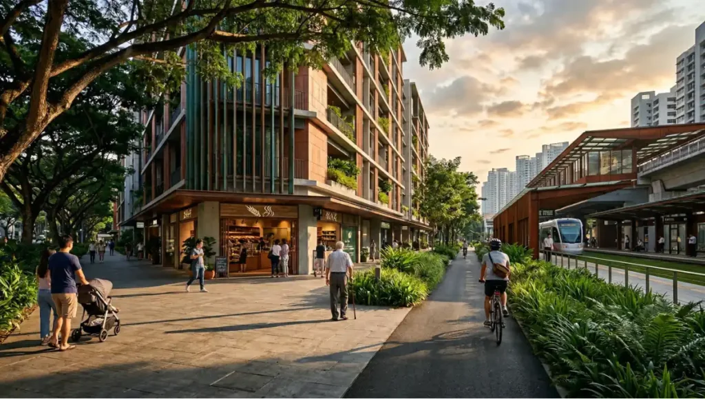
The 15-minute city concept, as articulated by Franco-Colombian scientist and urbanist Carlos Moreno at the Sorbonne in 2016, does not ask you to accept this condition as inevitable. It asks the inverse question: what would a city feel like if you could reach every essential function of daily life — work, commerce, healthcare, education, green space, and social activity — within 15 minutes under your own locomotion?
The answer to that question is not nostalgic. It is not a return to the pre-industrial village. It is a data-driven reconfiguration of urban density, zoning policy, transit infrastructure, and spatial equity — and it is arguably the most consequential urban design paradigm of the 21st century.
Nuvira Perspective: The City as a Recalibration Problem
| NUVIRA PERSPECTIVE At Nuvira Space, we do not treat the city as a static object to be managed. We treat it as a dynamic computational system — one that processes human behavior, resource flows, and ecological stress simultaneously. The 15-minute city concept is not, in our reading, a nostalgic return to neighborhood-scale urbanism. It is a disruption protocol. It is the architectural and policy argument that the metropolitan fabric has been catastrophically miscalibrated around the automobile and the speculative real estate market — two forces that privatized public time, fragmented social cohesion, and bankrupted municipal carbon budgets. Our position at the intersection of human-machine synthesis and data-driven design positions us to do more than observe this shift. We are here to accelerate, stress-test, and operationalize it. |
The language of “smart cities” has been colonized by technology vendors selling dashboards. Nuvira Space is not interested in dashboards. We are interested in the underlying spatial logic that determines whether a neighborhood functions as a self-sufficient urban ecosystem or as a dependent node in a dysfunctional metropolitan hierarchy.
The 15-minute city concept gives us the analytical frame. Data-driven design gives us the surgical instruments. What remains is the political will — and that, as we will examine, is where the real obstruction lies.
The Blueprint: Architecture of Proximity
Understanding the 15-minute city concept demands more than reading Moreno’s original formulation. It requires you to disassemble the concept into its operative components and examine how each one functions as a design lever within the built environment.
3.1 Moreno’s Four Operative Principles. 15-Minute City Concept Explained
The framework rests on four interdependent principles. Each one must be present for the system to function. Remove any one and the model collapses into a partial solution:
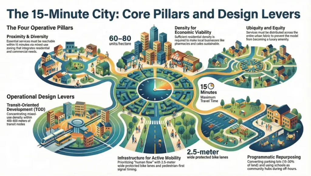
Principle 1: Proximity
- Essential services must be physically reachable within 15 minutes on foot or bicycle.
- This is not a suggestion about lifestyle. It is a spatial specification that governs land-use planning, density parameters, and the permissible distance between residential and commercial zones.
- Proximity is the master variable. All other principles serve it.
Principle 2: Diversity
- A single block or neighborhood unit must contain a mix of uses: residential, commercial, educational, recreational, and healthcare.
- Mono-functional zoning — the single-use suburban block — is the architectural enemy of the 15-minute city.
- Diversity requires legislative reform of Euclidean zoning codes that have dominated North American and many European cities since the mid-20th century.
Principle 3: Density
- Sufficient residential and commercial density is the prerequisite for economic viability of local services.
- A coffee shop, pharmacy, or primary school cannot survive within 400 meters of your residence if only 12 households occupy that radius.
- Density is not synonymous with overcrowding. It is the calibration of floor-area ratio, building height, and parcel coverage to support walkable service provision.
Principle 4: Ubiquity
- Services must be distributed equitably across the urban fabric — not concentrated in premium neighborhoods while peripheral districts remain underserved.
- Ubiquity is the equity dimension of the framework. Without it, the 15-minute city becomes a luxury amenity for gentrified districts.
- It demands active municipal investment in underserved areas and resistance to market-driven service clustering.
3.2 Design Levers: How Architects and Planners Operationalize the Framework
Transit-Oriented Development (TOD)
- Concentration of mixed-use density within 400–800 meters of transit nodes (metro, tram, bus rapid transit).
- Ground-floor commercial activation along pedestrian corridors radiating from transit anchors.
- Structured parking replacement with active frontage to reclaim street-level urban fabric.
- Minimum residential density of 60–80 units per hectare within the TOD radius to support service viability.
Infrastructure for Active Mobility
- Protected bicycle lane networks with a minimum width of 2.5 meters, physically separated from vehicular traffic by structural elements — not paint.
- Continuous pedestrian realm with shade canopies, street trees, and tactile paving for accessibility compliance.
- Intersection design prioritizing pedestrian crossing time over vehicular throughput — signal timing recalibrated from automobile flow to human flow.
- Last-mile micro-mobility infrastructure: covered bicycle parking, e-scooter docking stations, cargo bike lending programs.
- For a deeper analytical breakdown of how street hierarchy and right-of-way reallocation work in practice, see Nuvira Space’s dedicated guide on pedestrian-first city design.
Programmatic Repurposing of Underutilized Assets
- Conversion of surface parking lots — which occupy between 15–30% of total land area in many North American cities — to mixed-use development parcels.
- Temporal reprogramming of single-use buildings: schools as community hubs on weekends; office buildings as co-working and cultural venues after hours.
- Urban agriculture integration into underutilized rooftops, vacant lots, and linear park corridors to address food proximity.
Feasibility Study: Economic and Political Barriers
Here is where the idealism of the 15-minute city concept meets the machinery of political economy. The barriers to implementation are not technical. The design knowledge exists. The case studies are abundant. The resistance is structural — embedded in the financial interests that profit from the dysfunctional city. For a granular assessment of where implementation succeeds and stalls, Nuvira Space’s companion analysis on
the structural and legislative conditions required for real-world rollout is available at 15-minute city feasibility — a recommended parallel read to this analysis.
4.1 Economic Barriers
Property speculation in desirable urban neighborhoods creates a paradox at the heart of the 15-minute city model. The more successfully a neighborhood achieves proximity, diversity, and walkability, the more its land values escalate — triggering the displacement of the very population the framework was designed to serve. Paris, frequently cited as the most advanced large-scale implementation of the 15-minute city concept, has simultaneously experienced the gentrification of its inner arrondissements at rates that have pushed working-class residents to the périphérie — the car-dependent outer zones where 15-minute accessibility is structurally impossible.
This is not a failure of the concept. It is a failure of complementary housing policy. The 15-minute city requires parallel mechanisms: rent stabilization, community land trusts, inclusionary zoning, and anti-speculation taxation. Without these, proximity becomes a commodity sold to the highest bidder.
Key Economic Constraints
- Infrastructure retrofitting costs: converting car-oriented streets to pedestrian-priority corridors in mature cities averages $3–8 million per kilometer, depending on utility relocation requirements.
- Short-term commercial displacement during construction phases generates business loss and community opposition that can stall or kill projects politically.
- Property tax base realignment: cities heavily dependent on automobile-commercial strip retail tax revenue face fiscal disruption when transitioning to mixed-use, pedestrian-scale development models.
- Financing gaps for small-format mixed-use development: institutional lenders prefer large, mono-use assets. The small, mixed-use buildings that define walkable neighborhoods are structurally difficult to finance at scale.
4.2 Political Barriers
The automotive industry, the oil sector, the suburban housing development lobby, and the road construction industry represent a combined political force of extraordinary power in most Western democracies. Their interests are fundamentally misaligned with the 15-minute city concept. Each kilometer of new cycling infrastructure is a kilometer of road that does not get built. Each housing unit above a pharmacy is a house in a car-dependent suburb that does not get sold.
The conspiracy theories that emerged around the 15-minute city in 2022 and 2023 — largely amplified through social media ecosystems — are, paradoxically, evidence of the concept’s political potency. Fringe arguments that walkable neighborhoods are instruments of authoritarian surveillance reveal the depth of cultural anxiety around urban mobility freedom in car-dependent societies. Planners and architects must engage this anxiety directly rather than dismissing it.
Key Political Constraints
- Elected officials in car-dependent suburban districts face electoral consequences for any policy perceived as restricting automobile access or convenience.
- Municipal planning departments are structurally underfunded relative to state and national highway departments, creating a power asymmetry that favors road infrastructure over pedestrian realm investment.
- Zoning reform — essential for mixed-use development — requires navigating neighborhood opposition, legal challenges from existing property owners, and multi-year legislative processes.
- Intermunicipal coordination failures: the 15-minute city requires regional coherence. Individual municipalities cannot implement the concept in isolation when employment centers, hospitals, and universities span multiple jurisdictions.
Proof of Concept: Singapore’s Polycentric City-State
If the 15-minute city concept is to be defended as implementable rather than utopian, it must be grounded in a real-world example of sufficient scale and complexity to constitute genuine evidence. For this analysis, Singapore provides the most structurally instructive case — not because it is the most aesthetically celebrated, but because it is the most systematically engineered.
Singapore is, by almost every urban metric, the most successfully polycentric city-state in the world. Its Housing Development Board (HDB), established in 1960, has delivered over one million residential units organized into self-sufficient “new towns” — each designed to contain its own commercial node, healthcare facility, educational infrastructure, recreational park, and transit interchange within walking distance of all residents. Approximately 82% of Singapore’s population lives in HDB housing, meaning this is not a demonstration project for a privileged minority. It is the operative urban fabric of an entire nation.
The new town model — exemplified by Tampines, Bishan, and Punggol — achieves proximity metrics that Paris and Amsterdam are still structurally incapable of matching at equivalent population densities. Punggol, developed from 2010 onward as a “21st-century waterfront town,” integrates eco-corridors, smart home infrastructure, mixed-use commercial clusters, and a light rail transit loop into a coherent residential environment of 96,000 units. The average Punggol resident reaches their nearest MRT station, primary school, polyclinic, and commercial center within 10 minutes on foot.
What Singapore demonstrates, critically, is that the 15-minute city concept is not a product of European urban morphology or historical street grid inheritance. It is reproducible in a postwar, tropical, high-density context through deliberate policy, long-term planning authority, and rejection of single-use zoning at the foundational level of the master plan.
The lesson for architects and planners working in other contexts is not to replicate Singapore’s specific typology — its particular relationship between state authority and land development is not transferable to most democratic systems. The lesson is to replicate its insistence on proximity as a non-negotiable design criterion embedded in the statutory planning framework from day one of any development.
The American Institute of Architects (AIA) has documented comparable case studies in transit-oriented and mixed-use development through its Academy on Architecture for Health and its Communities by Design initiative. Their research reinforces that walkable, mixed-use environments demonstrably improve public health outcomes, reduce municipal infrastructure costs, and increase civic engagement. For practitioners seeking peer-reviewed evidence frameworks, the AIA’s published guidelines on
walkable urbanism and community design are accessible at aia.org/resources/communities-by-design.
Concept Project Spotlight
Speculative / Internal Concept Study | The Meridian Loop by Nuvira Space
Project Overview
| Location | Fictional mid-size coastal city, Southeast Asian climate zone — 28°C annual mean temperature, high humidity, monsoon season June–October |
| Typology | Mixed-use transit-oriented district | Area: 48 hectares | Population Target: 22,000 residents |
| Vision | A fully programmable urban district in which every resident achieves 15-minute access to all six service categories without automobile dependency, structured around a closed light-rail loop as the circulatory spine. |
The Meridian Loop is a speculative district conceived by Nuvira Space to stress-test the 15-minute city concept against the spatial constraints of a rapidly urbanizing Southeast Asian coastal context: high ambient heat, monsoon rainfall, limited land availability, and a demographic profile skewed toward young working households and elderly residents requiring healthcare proximity.
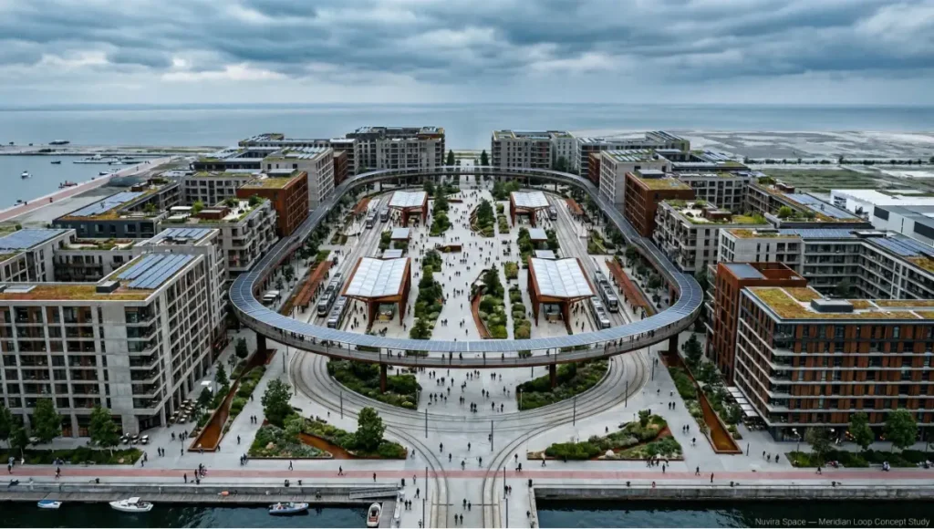
The project does not represent an available or completed design. It is an internal analytical construct — a computational model through which we examine which design decisions produce proximity outcomes and which produce trade-offs.
Design Levers Applied
Spatial Structure
- Closed light-rail loop of 3.2 km circumference with 6 stations, maximum station spacing of 530 meters, serving as the primary mobility armature.
- Six mixed-use “anchor clusters” positioned at each station, each containing a ground-floor market hall, a medical clinic, a co-working node, and a childcare facility.
- Residential typology: mid-rise (8–12 storeys) perimeter blocks with activated ground-floor commercial frontage on all street-facing elevations.
- A continuous elevated walkway connecting all six anchor clusters, shaded by photovoltaic canopy structures generating 40% of district electricity demand.
Climate-Responsive Infrastructure
- All pedestrian routes shaded to a minimum of 75% coverage through street tree canopy and structural shade systems — a non-negotiable parameter given the 28°C ambient baseline.
- Rain gardens and bioswale networks integrated into the street section, managing 100% of stormwater on-site during a 50-year rainfall event.
- Urban heat island mitigation through green rooftop coverage of minimum 60% of all building footprints above the 3rd floor.
Programmatic Mix
- Target land-use ratio: 45% residential / 25% commercial-mixed / 15% civic and educational / 15% open space and green infrastructure.
- Minimum ground-floor activation requirement: 85% of all street-facing building frontage within 200m of transit stations must be occupied by active commercial or civic use.
- Temporal programming: all civic buildings contractually required to offer community programming outside primary-use hours — a policy lever, not a design element.
Data Infrastructure
- Distributed IoT sensor network monitoring pedestrian flow, air quality, thermal comfort, and commercial occupancy in real time.
- Municipal data platform feeding into a predictive service-gap model that identifies proximity failures before they crystallize into physical displacement patterns.
- Open data architecture — all mobility and environmental data publicly accessible to residents, researchers, and competing urban design teams.
Transferable Takeaway
The Meridian Loop project reinforces a conclusion that Singapore has already demonstrated at national scale: proximity is an engineering problem, not a cultural aspiration. You can measure it, model it, specify it, and legislate it. The constraint is never technical imagination — it is the political decision to prioritize human locomotion over vehicular throughput as the foundational parameter of the master plan.
The design levers applied in this concept study are transferable to any mid-size urban expansion context where the planning framework is being written from scratch or substantially reformed. The critical window is always the statutory master plan — not the individual building.
2030 Future Projection: When 15 Minutes Becomes Algorithmic
The 15-minute city concept as currently practiced is a spatial model. It measures proximity in meters and minutes of physical travel. By 2030, this definition will be under pressure from three converging technological forces that expand what accessibility means without necessarily expanding what is physically reachable.

First, autonomous micro-mobility — shared electric vehicles operating without drivers in geofenced urban zones — will compress effective travel time for elderly and mobility-impaired residents who currently cannot achieve the walking or cycling benchmarks the framework assumes. A 15-minute walk for a 35-year-old is a 40-minute ordeal for a 75-year-old with reduced mobility. Autonomous micro-vehicles solve this without expanding automobile infrastructure.
Second, AI-assisted urban logistics — hyperlocal delivery systems operated by small autonomous ground vehicles — will bring pharmaceutical, grocery, and essential goods to your door within minutes, effectively extending the proximity of the distribution network into your residential unit. This does not replace the social and civic function of the walkable neighborhood. It augments the material access dimension, freeing the pedestrian realm for human interaction rather than freight movement.
Third, and most structurally significant, digital twins of urban districts will allow planning authorities to simulate the proximity consequences of every zoning decision, transit investment, and land-use change in real time before it is built. The gap between planning intent and lived proximity outcome — which currently takes decades to manifest — will close dramatically. Planners will be able to see, before a single foundation is poured, exactly which residents will gain or lose 15-minute access to which services as a result of a proposed development. The hardware layer that makes this possible — distributed environmental and mobility sensors embedded in streets, transit infrastructure, and building envelopes — is examined in detail in Nuvira Space’s technical guide on
smart city sensors, which maps the current hardware ecosystem against the data requirements of real-time proximity modeling.
By 2030, the 15-minute city concept will have matured from a manifesto into a measurable municipal standard. Several European and East Asian cities are already developing proximity indices — composite scores that rate every address in the city against the six service-access categories. Addresses that score below threshold will trigger automatic municipal investment obligations. This is the operationalization of the concept: not as a vision, but as a legal performance benchmark embedded in the statutory planning regime.
The risk in this future is standardization without equity. A proximity index managed by algorithms can be gamed by speculative developers who place nominal services — a single overpriced cafe branded as a “grocery store,” a digital kiosk labeled a “health information point” — to satisfy the metric without providing genuine access. Regulatory sophistication must evolve alongside the measurement technology.
Comprehensive Technical FAQ
Q: Is the 15-minute city concept applicable outside European contexts?
A: Yes — and Singapore is the definitive evidence. The concept is not dependent on pre-existing historical street grids, moderate climates, or specific cultural attitudes toward walking. It requires four conditions: sufficient density, mixed-use zoning, political commitment to active mobility infrastructure, and public investment in equitable service distribution. These conditions can be engineered in any urban context where planning authority exists. The challenge is greater in car-dependent cities with existing infrastructure that must be retrofitted, but the concept has been successfully applied in Melbourne’s “20-minute neighborhood” policy framework, in Edmonton’s Transit-Oriented Development guidelines, and in multiple new town developments across East Asia.
Q: Does the 15-minute city concept require eliminating cars?
A: No. The framework does not prohibit automobile use. It reconfigures the spatial and policy hierarchy so that automobile access is neither required for daily functioning nor subsidized by public infrastructure at the expense of pedestrian and cycling infrastructure. Residents in a functioning 15-minute district retain the option of car ownership. What they lose is the compulsion of car dependency — the condition in which the built environment makes every essential function structurally inaccessible without a vehicle. This distinction is critical for political communication. The concept is not anti-car. It is pro-choice in mobility.
Q: What is the relationship between transit-oriented development and the 15-minute city?
A: Transit-oriented development (TOD) is the primary spatial mechanism through which the 15-minute city concept is implemented at the district scale. TOD concentrates mixed-use density within walkable distance of transit nodes — metro stations, tram stops, bus rapid transit termini — creating the conditions in which a resident can reach multiple service categories within 15 minutes, using either the pedestrian realm or the transit network. Without TOD, the 15-minute city requires either extremely high uniform density across the entire urban fabric (which generates resistance) or an unrealistically fine-grained distribution of services. TOD provides the structural compromise: intense proximity around transit nodes, with residential fabric in between.
Q: How does the 15-minute city concept address urban heat islands and climate resilience?
A: The walkable, mixed-use neighborhood is inherently more climate-resilient than the car-dependent suburb for three structural reasons. First, reduced automobile infrastructure means reduced impervious surface coverage — less asphalt, less urban heat absorption. Second, the compact street network of a walkable neighborhood supports viable urban tree canopy coverage that is structurally impossible along high-speed arterial roads. Third, the social density of a functioning 15-minute district creates community networks that are demonstrably more effective at emergency response, mutual aid, and climate adaptation than the socially atomized structure of a low-density suburb. The concept is not inherently a green infrastructure framework — but its spatial logic is compatible with, and in many respects requires, green infrastructure integration.
Q: What metrics are used to evaluate whether a neighborhood qualifies as a 15-minute city?
A: The most rigorous current measurement frameworks assess proximity across six service categories:
- Healthcare: distance to nearest general practitioner, pharmacy, and emergency medical facility.
- Education: distance to nearest primary school, secondary school, and continuing education facility.
- Commerce: distance to nearest daily grocery provision, financial services, and diversified retail.
- Green space: distance to nearest public park or green recreational space of minimum 0.5 hectare.
- Employment: proportion of resident working-age population able to reach their workplace within 15 minutes without a car.
- Civic and cultural: distance to nearest library, community center, or civic gathering space.
Paris uses a composite Proximity Index that aggregates these six categories into a single address-level score. Amsterdam uses a similar framework called the “Kwaliteit Openbare Ruimte” (Quality of Public Space) index. Melbourne’s 20-minute neighborhood framework uses a slightly expanded category set that includes access to fresh food specifically.
Q: What is the minimum viable density for the 15-minute city concept to function?
A: Research from the Victoria Transport Policy Institute and various European planning agencies converges on a minimum residential density of approximately 35–50 dwelling units per hectare as the threshold below which 15-minute neighborhood service provision becomes economically unviable. At this density, local commercial operators, healthcare providers, and educational facilities cannot maintain sufficient clientele to remain solvent. Above 80 units per hectare, the full range of 15-minute services becomes economically self-sustaining. The sweet spot for most mid-rise, mixed-use implementation contexts is 60–80 units per hectare — achievable with 6–10 storey building typologies and 50–60% plot coverage.
The Architecture of the Next City Belongs to Those Who Specify It
You now have the analytical framework. You understand the operative principles, the design levers, the political economy of obstruction, and the proof of concept. What you do with this knowledge is the actual question.
If you are a municipal official, the 15-minute city concept gives you the policy architecture for a planning framework that can survive political cycles because it is grounded in measurable, resident-legible outcomes — not abstract design visions. Specify proximity benchmarks in your statutory planning documents. Mandate ground-floor activation in transit corridors. Reform your zoning code to permit mixed-use development by right rather than by exception.
If you are an architect or urban designer, the concept gives you the brief before the client has written it. Every project you accept in an urban context is an opportunity to either advance or obstruct the proximity agenda. The question is not whether your building looks good. The question is whether it activates the street, mixes uses, and contributes to a walkable service radius.
If you are a developer or investor, the 15-minute city is the most durable asset value proposition of the next 30 years. Properties with genuine walkability scores — not manufactured proximity theater — will outperform car-dependent assets as fuel costs, infrastructure maintenance burdens, and climate risk premiums systematically devalue the suburban land model.
Nuvira Space works with municipalities, design firms, and development organizations that are serious about the recalibration of the metropolitan fabric. We bring data-driven design methodology, computational proximity modeling, and a rigorous critical framework to the work of making cities function as they should — as generators of human flourishing, not consumers of human time.
The 15-minute city concept explained is not the destination. It is the compass. The work of building it starts with the next master plan, the next zoning amendment, the next street section drawing, and the next municipal budget line. That work begins now.
© Nuvira Space. All rights reserved. | URBAN PULSE Series | All specifications cited are based on peer-reviewed urban planning research, Housing Development Board Singapore (HDB) official publications, Victoria Transport Policy Institute technical reports, and Moreno, C. (2016). Droit à la Ville — Chrono-Urbanisme. The Meridian Loop is a speculative internal concept study and does not represent a completed project.