

The targets, systems, and data behind the transformation.
Table of Contents
| KEY TAKEAWAYS |
| ▸ Singapore’s shift from ‘Garden City’ (1965) to ‘City in Nature’ (2021) is the longest documented state-led urban greening experiment in the tropics — spanning six decades of iterative policy. |
| ▸ Over 7,800 hectares of green space have been protected; 832,000 trees planted toward a 1-million target by 2030, with 40%+ green cover maintained across a 728 km² island. |
| ▸ The Green Mark certification scheme — mandatory for new buildings since 2008 — targets 80% green-certified buildings by 2030, making it the world’s most comprehensive tropical green-building mandate. |
| ▸ Every resident is planned to live within a 10-minute walk of a park by 2030, delivering measurable equity across 5.9 million people in one of Asia’s densest city-states. |
| ▸ Singapore’s success is not transferable as a template — it is transferable as a methodology: long-range planning horizons, statutory enforcement, and cross-ministerial coordination define the replicable architecture. |
| ▸ The economic co-benefit of green infrastructure is quantified: the Khoo Teck Puat Hospital’s biophilic design reduced energy consumption by 30%, saving SGD 1 million annually. |
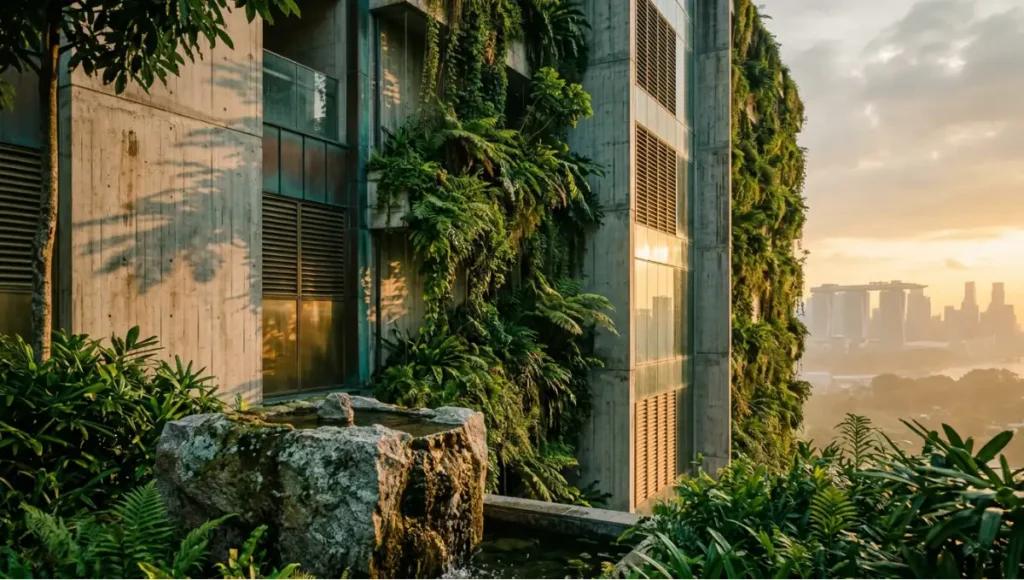
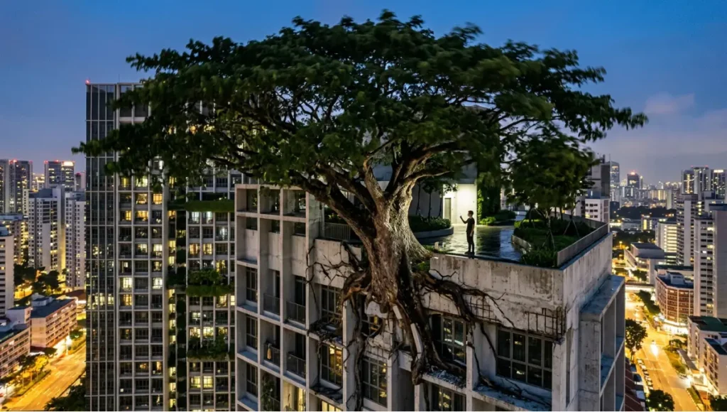
You are standing inside a contradiction. The city that surrounds you is one of the densest on earth — 25,000 residents per square kilometre in its urban core, its skyline a grid of towers pressing against the equatorial sky — and yet nearly half of its land surface is green. Trees push through bridge railings. Vertical gardens cascade fourteen stories. Reservoirs double as parks. This is not accidental landscaping. What you are witnessing is the accumulated result of sixty years of Singapore green urban planning: a sustained, statutory, data-driven redesign of what a tropical megacity is allowed to become.
Most global cities treat green space as a residual category — what is left after infrastructure claims its share. Singapore reversed that hierarchy before the concept had a name. The question this case study puts directly to you is not whether the outcomes are admirable. The question is: which of the mechanisms, the institutional architectures, the enforcement levers, produced those outcomes, and what would it cost — politically, economically, and structurally — to replicate them elsewhere?
That is the only honest version of this conversation. The rest is tourism.
Nuvira Perspective
At Nuvira Space, we treat the city as a living system that fails or succeeds at the intersection of human behaviour, material infrastructure, and political will. The received wisdom of urban planning positions green space as amenity — a soft supplement to the hard work of roads, utilities, and housing. Singapore’s thirty-year record demolishes that framing with evidence. Green infrastructure is hard infrastructure — thermal regulator, stormwater system, biodiversity corridor, and public health asset simultaneously.
Our analysis of Singapore’s trajectory confirms what data-driven urban design has long suggested: the cities that will survive the climate pressures of the next three decades are not those that retrofit green space into finished urban fabric, but those that encode ecological performance into every zoning decision before ground is broken.
The architecture profession is beginning to formalise this understanding. The American Institute of Architects, in its most recent analysis of regenerative design, explicitly references Singapore’s Green Plan as a benchmark for bioclimatic integration — recognising that the island’s planning record represents not an outlier, but a proof of concept for what the AIA calls the regenerative design journey: the alignment of buildings, landscapes, and urban systems into a single ecological performance framework. The Nuvira framework reads Singapore not as an exceptional outlier but as a proof of concept for a disciplined planning methodology.
What made the difference was not geography, wealth, or authoritarian governance alone — it was the thirty-year planning horizon, the cross-ministerial coordination infrastructure, and the refusal to treat sustainability as a departmental silo. Those are replicable. The political courage to mandate them is the variable that most cities have not yet resolved.
The Blueprint Solution: Six Mechanisms That Built a Green City
Singapore green urban planning did not emerge from a single policy decision. It accumulated through six interlocking mechanisms, each reinforcing the others over successive planning cycles. To understand the outcome, you must understand the system.
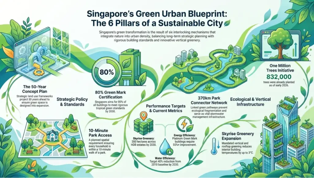
The 6 Pillars of a Sustainable City
1. The Long-Range Concept Plan Architecture
Since 1971, Singapore has operated under a Concept Plan — a strategic land-use framework projecting fifty years into the future. Revised once per decade, it is the instrument through which green space is not merely protected but actively designed into urban expansion. The Concept Plan feeds into the Master Plan, updated every five years, which translates strategic intent into statutory zoning. Developers do not lobby against green requirements at the Master Plan stage; they design with them from feasibility.
2. Statutory Green Certification — The Green Mark Regime
Introduced in 2005 and made mandatory for new buildings in 2008, the Building and Construction Authority’s Green Mark scheme is the world’s most rigorous tropical-context green building standard. It scores across:
- Energy Efficiency: Minimum 28% improvement over baseline; Platinum tier requires 55%+
- Water Efficiency: Mandatory sub-metering; targets 40% reduction from 2010 baseline by 2030
- Greenery Provision: Green Plot Ratio (GnPR) quantifying vertical and horizontal vegetation
- Indoor Environmental Quality: Thermal comfort, air quality, daylight penetration
- 2030 Target: 80% of all buildings in Singapore to hold Green Mark certification
The Khoo Teck Puat Hospital, completed in 2010, remains the architectural benchmark: 2,000+ plant species integrated into a public hospital, 30% energy reduction versus comparable facilities, SGD 1 million saved annually. It demonstrated that biophilic design was not an aesthetic premium — it was an operational efficiency.
3. The Park Connector Network — 370 km of Ecological Corridor
Singapore’s park connector network is not a recreational amenity. It is a biodiversity corridor system — 370 kilometres of linked green pathways that prevent ecological fragmentation across a heavily urbanised island. The connectors function simultaneously as ecological transit routes and as the city’s primary stormwater management infrastructure — a principle explored in depth in Nuvira’s guide to sponge city infrastructure. This is the structural innovation that separates Singapore’s approach from city-centre greening gestures: the connectors ensure that species movement, not just human movement, is designed into the city’s spatial plan.
4. Skyrise Greenery — Vertical Reclamation of the Urban Surface
On a 728 km² island where horizontal land is a rationed resource, Singapore mandates the reclamation of built surface area through vertical and rooftop greening. The science underpinning this mandate goes beyond aesthetics: as Nuvira’s analysis of living walls and indoor air purification demonstrates, planted vertical surfaces actively filter particulate matter and volatile organic compounds, translating green coverage into measurable indoor environmental quality gains. Current metrics:
- Existing Skyrise Greenery: 100+ hectares of rooftop gardens and green walls as of 2023
- 2030 Target: 200 hectares of skyrise greenery across HDB estates
- Thermal Performance: Vertical green walls reduce interior building temperatures by up to 3°C
- Flood Mitigation: Green roofs absorb and delay stormwater runoff during high-intensity rainfall events
5. The One Million Trees Initiative — Canopy as Carbon Infrastructure
Launched under Green Plan 2030, the one million trees target functions simultaneously as carbon sequestration infrastructure, urban heat island mitigation, and public health investment. Progress as of January 2026: 832,000 trees planted, with over 150,000 community participants enrolled. The initiative is on trajectory for the 2030 target with 1,000 additional hectares of green space committed under the URA Master Plan for implementation by 2035.
6. The 10-Minute Park Access Standard
By 2030, every household in Singapore will be within a ten-minute walk of an accessible park. This is not an aspiration — it is a planned spatial outcome enforced through the Master Plan’s green space allocation requirements. In planning terms, it means that no residential development can be approved without accounting for its residents’ green space access as a measurable, verifiable urban service.
Feasibility Study: Economic and Political Barriers
The honest version of Singapore green urban planning’s global relevance is that it operates under conditions most cities do not share. You need to confront these barriers directly before deploying any part of this model elsewhere.
Economic Barriers
The Land Acquisition Advantage
Singapore’s Land Acquisition Act (1966) gave the state near-total authority to compulsorily acquire land at below-market rates for public purposes. This instrument, used aggressively through the 1970s and 1980s, allowed planners to reserve green corridors before land values made them prohibitive. No liberal democratic city can replicate this without constitutional confrontation. The lesson is not to copy the mechanism — it is to front-load green space reservation before urbanisation raises land costs to the point of impossibility.
The Green Infrastructure Cost Structure
Biophilic building integration adds approximately 3–8% to construction costs at the Green Mark base tier. At Platinum tier — the standard Singapore is pushing toward — the premium rises to 12–18% before lifecycle savings are calculated. The economic argument for green infrastructure depends entirely on the accounting horizon:
- 5-Year Horizon: Green buildings typically cost more to construct than conventional equivalents
- 15-Year Horizon: Operational energy savings typically recover the construction premium
- 30-Year Horizon: Reduced urban heat island effect, lower cooling loads, and improved tenant productivity generate net positive returns
- Public Health ROI: Green space access reduces healthcare costs; Singapore’s integrated parks are funded partly through health ministry budget allocations
Political Barriers
The Planning Horizon Problem
Singapore’s fifty-year Concept Plan exists because its founding government had both the institutional stability and the political will to plan beyond electoral cycles. Most municipal governments operate on four-year planning cycles — a horizon too short for green infrastructure investments whose returns are measured in decades. The political challenge is not technical. It is temporal. Green urban planning requires that elected officials make expensive, visible commitments whose beneficiaries will vote in elections not yet scheduled.
The Enforcement Architecture
Singapore’s green building mandate works because it is enforceable. The Green Mark scheme has statutory backing; non-compliance results in development approval denial, not a financial penalty that developers can absorb as a cost of doing business. Cities that introduce green building guidelines without statutory teeth will produce voluntary uptake by developers who were already building green. The mechanism must be binding to shift the mean.
Proof of Concept: Singapore’s 30-Year Verified Record
The data below is drawn from government-published sources, peer-reviewed urban ecology research, and verified parliamentary records. This is not projection — it is the documented output of thirty years of sustained Singapore green urban planning.
Phase 1: Garden City Foundation (1965–1990)
Lee Kuan Yew’s Garden City vision, articulated at independence in 1965, began with street tree planting campaigns that seem modest by contemporary standards. Their significance was institutional: they established the precedent that the urban environment was a state responsibility, not a market output. By 1990, Singapore had:
- Tree Coverage: Consistent street tree presence across all major arterials
- Planning Mechanism: URA Master Plan incorporating green space minimums
- Institutional Architecture: National Parks Board established (1990) as the statutory body for park management
Phase 2: ‘City in a Garden’ — Systemic Integration (1990–2010)
The shift from ‘Garden City’ to ‘City in a Garden’ was semantic but strategically significant: the first positions nature as an ornament to the city; the second repositions the city as an element within a larger natural system. During this phase:
- Park Connector Network: 370 km of ecological corridors developed
- Green Mark Scheme: Launched 2005, made mandatory 2008
- Bishan-Ang Mo Kio Park: Concrete drainage canal redesigned as naturalised river corridor — one of Asia’s most cited urban river restoration projects
- Green Cover: Maintained above 40% despite sustained population and economic growth
Phase 3: City in Nature — Ecological Systems Thinking (2021–Present)
The Singapore Green Plan 2030, launched in 2021, represents the third and most ambitious phase. Its City in Nature pillar sets the following verified and targeted outcomes:
- Green Space Protected: 7,800+ hectares across nature reserves, nature parks, and park connectors
- Trees Planted: 832,000 of 1,000,000 target (January 2026 data)
- Skyrise Greenery Target: 200 hectares of rooftop and vertical greenery by 2030
- Nature Park Expansion: 200 additional hectares of new nature parks by 2030
- Habitat Restoration: 80 hectares of restored forest, marine, and coastal habitats
- Species Recovery: Plans for 100 plant species and 60 animal species by 2030
- Park Access Standard: Every household within 10-minute walk of a park
- Net Zero Target: 2050 — the long-range fiscal horizon for the full green system
The cumulative outcome: Singapore now holds over 40% green cover on an island that has simultaneously grown its population, GDP, and built environment density over the same thirty-year period. That simultaneity is the verified proof of concept.
Concept Project Spotlight
Speculative / Internal Concept Study — Canopy Commons by Nuvira Space
Project Overview
- Location: Typology-agnostic — designed for application in high-density tropical cities (primary reference: Singapore’s Tengah Forest Town model)
- Typology: Mixed-use transit-oriented development node integrating residential, commercial, and ecological corridor infrastructure
- Scale: 12-hectare urban block, designed for 4,200 residential units and 38,000 m² of commercial floor area
- Vision: A reconfigured urban block in which the ecological corridor precedes the built environment — green infrastructure as the load-bearing structure around which human programme is organised, not accommodated
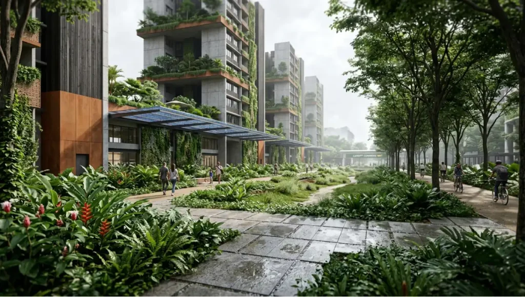
Canopy Commons inverts the conventional development sequence. Where standard mixed-use development begins with a structural grid and adds greenery at completion, Canopy Commons begins with a mapped ecological corridor and derives the built-form geometry from it. The result is a development in which the green system is continuous, performative, and irreducible — not a surface treatment that could be value-engineered out.
Design Levers Applied
Ecological Spine — The Non-Negotiable Corridor
- Central 2.4-hectare planted corridor at grade — continuous from north to south boundary
- Minimum 18-metre clear width maintained throughout corridor to support species movement
- Native species composition: minimum 70% native to Singapore’s bioregion, per NParks’ species guidance
- Integrated stormwater bioswales replacing 100% of engineered drainage within the corridor
- Ground-level permeability: 55% of site area unpaved or porous-paved
Vertical Green Infrastructure
- All residential towers: mandatory GnPR (Green Plot Ratio) of 4.0 — four times the planted area relative to site footprint
- Sky terraces at every 6th floor: minimum 80 m² planted area per terrace
- Green walls on all east- and west-facing elevations: minimum 40% coverage, native climbers on engineered substrate
- Rooftop photovoltaic integration: 3,200 m² of combined solar-green roof (agrivoltaic configuration)
- Thermal modelling target: 2.8°C reduction in near-building ambient temperature versus bare-surface baseline
Transit and Active Mobility Integration
- Zero private vehicle access within the development footprint — all parking below grade, accessed from perimeter road only
- Direct-access MRT link at northern node — maximum 400-metre walk from furthest residential unit
- 8.6 km of internal cycling and pedestrian paths — all shaded by canopy or overhead trellis structures
- Dedicated last-mile micro-mobility charging bays integrated into commercial ground floor
Performance Specifications
- Energy Use Intensity: Target 95 kWh/m²/year — 42% below Singapore’s 2022 commercial building average
- Water Recycling: 100% greywater recycling within development via closed-loop NEWater-aligned system
- Biodiversity Index: Target Biodiversity Friendly Building certification under NParks framework
- Carbon Embodied: Structural concrete replaced by 40% recycled aggregate; steel specified at minimum 70% recycled content
- Community Green Stewardship: Minimum 20% of corridor management delegated to resident community groups
Transferable Takeaway
Canopy Commons is not a Singapore-specific proposal. Its transferable value lies in the sequence: decide the ecological corridor first, make it statutory and dimensionally non-negotiable, then derive all built-form decisions from that constraint. This planning inversion is applicable in any high-density tropical city where land acquisition for green space must compete with development economics. The methodology works precisely because it eliminates that competition by establishing green infrastructure as the site’s primary structural condition — before any development value is priced in.
2030 Future Projection: What Comes After the Verified Record
Singapore’s Green Plan 2030 represents the most fully specified near-term projection in urban ecological planning. By 2030, the verified targets, if met on current trajectory — and January 2026 data suggests they will be — will produce a city that has simultaneously:
- Planted one million trees on an island smaller than Greater London
- Brought 200 hectares of its rooftop and vertical surfaces into biological productivity
- Restored 80 hectares of forest, marine, and coastal habitat within city limits
- Placed every one of its 5.9 million residents within ten minutes of a park
- Certified 80% of its building stock to the world’s most demanding tropical green-building standard
- Advanced species recovery programmes for 100 plant and 60 animal species
The more consequential projection is what happens beyond 2030. Singapore has already committed to 1,000 additional hectares of green space in the URA Master Plan, to be progressively delivered by 2035. The net-zero 2050 trajectory requires that green infrastructure’s thermal and carbon-sequestration performance be quantified and audited at scale — a systems challenge that Singapore is uniquely positioned to solve, given that it is simultaneously the living laboratory and the regulatory authority.
The global relevance of this trajectory is not that other cities should follow Singapore’s exact programme. It is that Singapore will, by 2030, have produced the most comprehensive dataset ever assembled on what systematic green urban planning does to a city’s thermal performance, biodiversity index, public health outcomes, and economic resilience over a thirty-year period. That dataset will be the most valuable planning resource produced in the twenty-first century. The cities that study it now will be better prepared to act on it.
Comprehensive Technical FAQ
Q: Is Singapore’s green urban planning model transferable to other cities?
A: Partially. The specific instruments — land acquisition powers, single-party planning authority, Green Mark statutory mandate — depend on Singapore’s unique governance structure. What is transferable is the methodology: long-range Concept Plans that precede market activity, green space allocation as a non-negotiable zoning requirement, and cross-departmental budgeting that treats green infrastructure as public health and climate infrastructure, not as a parks department line item.
Q: What measurable impact has Singapore’s greening had on urban heat?
A: Green walls in Singapore reduce near-surface temperatures by up to 3°C. The urban heat island effect in Singapore’s central business district is estimated at 4–6°C above surrounding areas — a differential that would be significantly higher without the existing green infrastructure network. Surface material choices compound this effect; for a detailed technical breakdown of how pavement selection affects urban heat, see Nuvira’s analysis of cool pavement and urban heat island mitigation. The 200-hectare skyrise greenery target for 2030 is explicitly calibrated to extend thermal buffering across the residential HDB estate network.
- Green Wall Thermal Performance: Up to 3°C surface temperature reduction
- Green Roof Stormwater Performance: Absorption and delay of runoff during high-intensity rainfall
- Park Cooling Radius: Documented cooling effect extending 100–200 m from park boundaries
Q: How does Singapore fund its green infrastructure at this scale?
A: Through a combination of statutory levies (developers fund green requirements as part of development approval conditions), National Parks Board budget (funded through consolidated central government allocation), and cross-ministerial contributions from Health, Environment, and National Development ministries. The Green Mark scheme also creates a private-sector investment stream: developers investing in Platinum-tier certification access development intensity bonuses in certain zones.
- Developer Contribution: Green requirements are conditions of development approval — not incentivised, but mandated
- Cross-Ministry Budgeting: Green space investment allocated across Health, Environment, and National Development ministries
- Public-Private Partnerships: Biodiversity impact assessments (BIA) required of private corporations; CDL set Southeast Asia’s first net-zero corporate target
Q: What is Singapore’s Green Plot Ratio (GnPR) and how is it enforced?
A: The Green Plot Ratio (GnPR) is a planning metric developed by NParks that quantifies the total planted area of a development, including vertical and rooftop surfaces, as a ratio of the site footprint. A GnPR of 3.0 means a site has planted area equivalent to three times its ground coverage. It is enforced through the development approval process: submitted plans must demonstrate a minimum GnPR before building permits are issued.
- GnPR Minimum (Residential): 3.0 in most residential zones; higher in key nodes
- GnPR Measurement: Ground-level planting × 1.0 + Rooftop × 1.0 + Vertical × 0.5 (per Leaf Area Index calculation)
- Enforcement Mechanism: BCA/NParks joint review; non-compliant plans receive approval deferral
Q: How does biophilic design in Singapore differ from standard green building practice?
A: Standard green building practice targets energy and water efficiency. Biophilic urban design targets the restoration of human-nature interaction as a functional component of the built environment. Singapore’s approach, exemplified by Khoo Teck Puat Hospital and Jewel Changi Airport, integrates living systems — plants, water, biodiversity — as functional elements of building performance, not as decorative supplements. The measurable difference is that biophilic buildings in Singapore demonstrate health outcome improvements for occupants — reduced recovery times in healthcare settings, documented productivity gains in workplace settings — that are attributable to the ecological interface, not merely to energy efficiency.
Q: What is the role of community participation in Singapore’s green urban planning?
A: It is structural. The one million trees initiative enrolled over 150,000 community participants in active tree planting. NParks’ community-in-bloom programme transfers ongoing management of designated green spaces to resident groups. In Canopy Commons (the Nuvira concept), a minimum 20% of corridor management is explicitly delegated to resident stewardship — because long-term ecological performance depends on continuous human engagement, not periodic municipal maintenance.
The City You Build Next
Every urban planning decision you make today is infrastructure for a climate that will be measurably different in thirty years. Singapore green urban planning’s most important lesson is not about trees, buildings, or parks. It is about time. The city that will be liveable in 2055 is being zoned, approved, and built right now — and the decisions being made about green cover, ecological corridors, and building performance standards will be irreversible within a decade.
You are not short on evidence. Singapore’s thirty-year verified record provides the most rigorous dataset available on what systematic urban greening produces — thermally, ecologically, economically, and in terms of public health. The methodology is documented. The instruments are described. The outcomes are quantified.
The question is whether the cities studying Singapore’s record will act with the same planning horizon that produced it. A fifty-year Concept Plan. A mandatory, enforced green-building standard. An ecological corridor that precedes the development, not follows it.
At Nuvira Space, we work with the conviction that the metropolitan fabric can be recalibrated — not through incremental adjustment, but through the kind of structural, data-led redesign that Singapore has demonstrated is both possible and measurable. The tools exist. The evidence exists. The decision left is political, not technical.
The city you build next will be someone’s entire world. Build it accordingly.
© Nuvira Space All rights reserved. | URBAN PULSE Series All specifications cited are based on Singapore Green Plan 2030 (greenplan.gov.sg), NParks City in Nature Key Strategies (nparks.gov.sg), Building and Construction Authority Green Mark Framework (bca.gov.sg), World Economic Forum Nature-First Urban Planning Report (January 2025), the AIA article on Regenerative Design (aia.org), and peer-reviewed data from Tandfonline Biophilic Urbanism Case Study, ResearchGate Singapore Ecosystem Services (April 2017), and Parliamentary records on Green Plan progress (February 2026).