

Table of Contents
Key Takeaways
- Low-density suburban development produces 2.0–2.5× more GHG emissions per capita than high-density urban cores, according to life-cycle analysis from the Journal of Urban Planning and Development.
- Doubling job density within a transit-oriented corridor increases economic productivity by 5–10%, per World Bank data.
- High-density cities that invest in transit-oriented development (TOD) reduce per-household car ownership to fewer than 1 vehicle, compared to 2+ in sprawl-dominant metros.
- Infrastructure maintenance costs for low-density municipalities can consume up to 40% more per resident due to road length, utility runs, and service dispersal.
- Singapore’s Mass Rapid Transit (MRT) — spanning the entire island — demonstrates that compact, high-density urban form and multi-modal transit can achieve near-zero peak congestion at dense employment nodes.
- The binary of “density vs. sprawl” is a false political construct; the real variable is design intelligence applied at the neighborhood scale.
- By 2030, cities that fail to embed resilient infrastructure into their density frameworks risk systemic fiscal collapse of their public service networks.
At Nuvira Space, We Reject the Comfortable Lie of Sprawl
At Nuvira Space, the debate over high density vs low density urban growth is not a planning preference — it is a structural indictment of how cities have been built for the past seventy years. We occupy the intersection of human-machine synthesis and metropolitan recalibration: a vantage point where every zoning map, infrastructure budget, and mobility dataset tells a story most planners are reluctant to finish reading.
Nuvira’s editorial mandate is not to comfort the profession with balanced perspectives. It is to arm you — the urbanist, the developer, the policymaker — with the disruptive, evidence-grounded clarity that the metropolitan fabric demands. The city is not a product of nature. It is an engineered artifact. And like all artifacts, it can be reverse-engineered, stress-tested, and redesigned.
The Blueprint Solution: Reframing the Density Debate Through Design Intelligence
The term “density” has been weaponized by both sides of the urban planning spectrum — wielded by densification advocates as a synonym for sustainability, and by sprawl defenders as shorthand for congestion and diminished quality of life. Both camps are operating on incomplete data. The correct analytical frame is not how much density, but what kind, and critically, where and how it is supported.
The 5D Framework: What Density Actually Measures
Researchers evaluating Singapore’s 23 rail station areas have developed a rigorous built-environment model based on five dimensions that determine whether density functions as an asset or a liability:
Dimension 1 — Neighborhood Spatial Form
- Floor Area Ratio (FAR) targets: urban core zones → 5.0–8.0; transitional neighborhoods → 2.5–4.0
- Block permeability: maximum 150m between public through-routes
- Street-level activation: minimum 60% of ground-floor façade in active commercial or civic use
Dimension 2 — Facility Completeness
- Essential services (grocery, primary healthcare, childcare) within 400m of any residential unit
- School access by foot or protected cycling route within 800m
- Emergency response infrastructure calibrated per 1,000 residents, not per hectare
Dimension 3 — Open Space Allocation
- Minimum 9m² of publicly accessible green space per resident (WHO benchmark)
- Rooftop and vertical garden integration counted at 50% of equivalent ground-level area
- Stormwater biophilic corridors embedded in block structure — not bolted on as afterthought
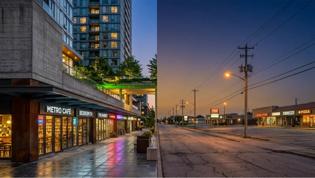
Dimension 4 — High-Density Mixed Land-Use Integration
- Commercial-to-residential ratio indexed to transit ridership capacity
- Prohibition of mono-functional zoning within 500m of any transit node
- Productive ground floors: retail, co-working, maker space, or civic programming — no dead podium parking
Dimension 5 — Walking Amenity Factor
- Pedestrian comfort index: shade coverage, street furniture, tactile paving, universal accessibility
- Average block size target: under 80m × 80m in core zones
- Continuous awning or arcade provision on primary retail streets in tropical and high-rainfall climates
Feasibility Study: Economic and Political Barriers to Intelligent Densification
The Fiscal Arithmetic of Low-Density Sprawl
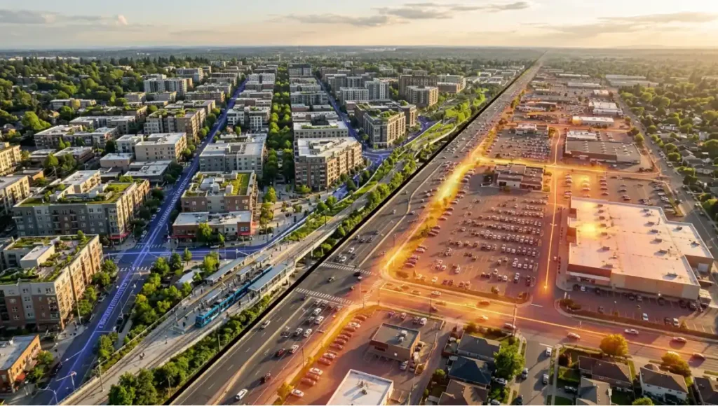
You have been told that low-density suburban living is affordable. The household-level economics may appear to support that claim: larger plots, lower per-square-meter purchase prices, quieter streets. What the real estate brochure omits is the municipal balance sheet.
Low-density municipalities face a structural fiscal paradox: their service areas cover vast physical territory, but their tax base per hectare is dramatically thinner than compact urban cores. A big-box retail node generates a fraction of the per-unit municipal revenue that a mixed-use transit-adjacent block produces. Public roads, water mains, fiber networks, and emergency service routes are all geometrically longer — requiring more material to build and more labor-hours to maintain across wider dispersal.
A 2006 Toronto-based life-cycle assessment, published in the Journal of Urban Planning and Development, quantified the consequence: low-density suburban development generates 2.0 to 2.5 times more energy use and GHG emissions per capita than high-density urban core development. When the functional unit shifts to per-unit-of-living-area, the ratio narrows to 1.0–1.5× — but critically, the advantage of low-density development never reverses. The primary driver is transportation: private automobile dependency in sprawl environments generates emissions that no amount of building-level efficiency can compensate for.
The Political Barriers: Where Zoning Law Becomes Cultural Mythology
The resistance to high-density development is not primarily technical — it is political and psychographic. Homeowner associations, incumbent property holders, and single-family zoning protections have constructed a legislative architecture that treats density as a threat to “neighborhood character.” This framing has frozen entire metropolitan regions in a low-density equilibrium that is fiscally, environmentally, and socially unsustainable.
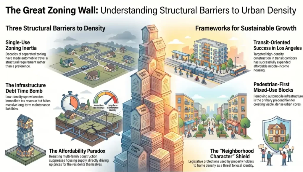
Three structural barriers define the political landscape:
1. Single-Use Zoning Inertia Decades of Euclidean zoning — separating residential, commercial, and industrial uses into discrete geographic siloes — have produced environments where the automobile is not a preference but a structural requirement. Dismantling these codes requires political will that conflicts directly with the electoral interests of existing property owners.
2. Infrastructure Debt Concealment Low-density developments generate immediate tax revenue from new construction, but their long-term infrastructure maintenance liability is rarely accrued on municipal balance sheets. This accounting gap allows sprawl to appear financially viable in the short term while creating deferred fiscal crises — what urbanists call “the infrastructure debt time bomb.”
3. Density-Phobia and the Affordability Paradox The communities most resistant to high-density development are often those experiencing the most acute housing affordability crises. The opposition to multi-family construction in high-demand zones directly suppresses housing supply, driving prices upward for the very demographic that opposes new development. Los Angeles has demonstrated this dynamic at scale: targeted high-density apartment construction in transit corridors has incrementally expanded affordable housing supply for middle-income households — yet political resistance to further upzoning continues.
The structural logic of mixed-use, pedestrian-first urban blocks is explored in depth in Nuvira’s analysis of car-free city district design — a framework that makes the political and technical case for removing automobile infrastructure from the urban core as the precondition for viable densification.
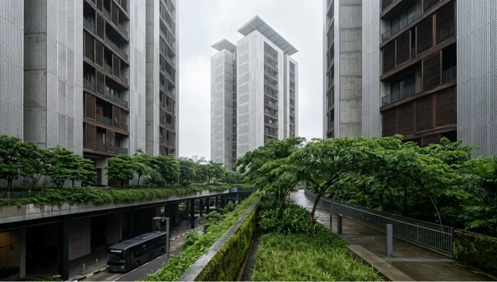
Proof of Concept: Singapore’s Quantified Urban Laboratory
Singapore is not a planning utopia. It is a 733km² pressure test — an island city-state that has had to solve the high density vs low density urban problem not as a theoretical debate but as a physical survival constraint. What makes Singapore’s model analytically valuable is not that it is replicable wholesale (it is not — its political centralization and land-tenure system are unique), but that it provides the most rigorously documented dataset on high-density TOD performance in the world.
The Mass Rapid Transit network, initiated in the 1970s and now spanning the entire island, was not built alongside land use policy — it was land use policy. Housing estates, commercial nodes, schools, and civic infrastructure were designed around station catchment areas from the outset, not retrofitted to an existing transit spine. The result is a constellation of self-sustaining satellite towns — Tampines, Jurong East, Punggol — each capable of meeting the daily needs of residents within a walkable radius of their MRT station, dramatically reducing the structural demand for private automobile ownership.
At Marina Bay, the model reaches its highest expression. The precinct — built on 360 hectares of reclaimed land — integrates high-density office towers with public parks, pedestrian promenades, and the Gardens by the Bay biophilic infrastructure, all within direct MRT access from any point on the island. According to World Bank analysis, despite a very high concentration of employment, Marina Bay generates near-zero peak congestion — a consequence of transit modal share so high that private vehicle demand is systemically suppressed.
The data from Singapore’s TOD experience supports the World Bank’s quantified finding: doubling job density in a transit-served corridor increases economic productivity by 5–10%. The mechanism is agglomeration: the compression of knowledge workers, supply chains, and service ecosystems into a compact geography creates interaction frequencies that dispersed environments cannot replicate at any price point.
Three measurable outcomes from Singapore’s high-density urban model:
- Modal shift: Over 70% of peak-hour trips are made on public transit, compared to under 10% in most North American sprawl metros
- Land efficiency: Singapore accommodates 5.9 million people on 733km² through vertical density and mixed-use zoning, preserving over 30% of its land area as parks and nature reserves
- Carbon trajectory: Per-capita transport emissions are among the lowest of any high-income global city, driven by transit modal share and the structural absence of automobile dependency
The climate-adaptive infrastructure layer beneath Singapore’s density model — its bioswales, retention basins, and flood-resilient site grading — is a category that Nuvira has examined separately in its sponge city infrastructure guide, which quantifies how water-sensitive urban design functions as a structural complement to high-density development rather than a cosmetic addition.
Concept Project Spotlight
Speculative / Internal Concept Study — “Meridian Stack” by Nuvira Space
Project Overview
Location: Hypothetical mid-density coastal corridor, modeled on Southeast Asian climatic and demographic parameters (35°C peak ambient / high humidity / monsoon-season flooding risk)
Typology: Vertical mixed-use transit village — 12 residential towers (28–42 floors), integrated podium retail, civic programming base, and elevated green corridor network
Vision: To demonstrate that the high density vs low density urban binary can be dissolved through precision layering — achieving the social texture of low-density neighborhood life within a high-density structural envelope
Design Levers Applied
Lever 1 — The Vertical Street Section
- Ground floor (0–6m): Activated public realm — markets, health clinic, childcare, community hall
- Podium level (6–18m): Elevated park deck — 4,200m² of landscaped green, cycle track, and rain garden bioswale
- Tower base (18–45m): Co-living and co-working hybrid typology — flexible floor plates, shared amenity floors at every 8th level
- Tower mid (45–100m): Standard residential — 62m² average unit, cross-ventilated layouts, operable balconies
- Tower crown (100m+): Urban agriculture terrace, photovoltaic canopy, rainwater capture array
Lever 2 — Transit Integration Specifications
- Dedicated BRT (Bus Rapid Transit) spine running beneath the podium — 4-minute frequency, zero at-grade conflict with pedestrian flow
- Bike-share dock at every tower lobby — 40 berths per tower minimum
- EV charging infrastructure embedded in all parking structures — 100% of stalls pre-wired, 30% active at Phase 1
- Last-mile autonomous shuttle loop serving a 1.2km perimeter — operational from project completion
Lever 3 — Climate Resilience Systems
- Flood-resilient podium base: all critical infrastructure elevated ≥3.5m above projected 2050 100-year flood line
- Passive cooling via canyon effect: tower spacing and orientation calibrated to maximize prevailing wind capture
- Green-Blue corridor: 18m-wide biophilic channel running the full 480m site length, integrating stormwater detention and biodiversity habitat
- District cooling loop: shared chilled water network servicing all 12 towers — estimated 38% reduction in building HVAC energy versus individual systems
Lever 4 — Economic Feasibility Metrics
- FAR: 7.2 (achievable within standard high-density zoning with ground-floor bonus provisions)
- Affordable housing allocation: 22% of total residential units at subsidized tenure (cross-financed by commercial podium revenue)
- Projected infrastructure cost per resident: 34% lower than equivalent low-density greenfield development of equivalent population
- Break-even timeline on podium commercial investment: 8.5 years at 85% occupancy (conservative scenario)
Transferable Takeaway
The Meridian Stack is not a blueprint for replication — it is a demonstration of method. Every design lever applied here is available to any planner operating within a high-density framework: vertical programming, transit-first mobility infrastructure, climate-resilient base levels, and cross-subsidized affordability. The critical lesson is sequence: transit infrastructure must be designed before residential towers, not after. The failure of most high-density developments to deliver livability outcomes is not a density failure — it is a sequencing failure.
2030 Future Projection: The Cities That Will Survive the Fiscal Reckoning
The 2030 horizon is not distant. It is the deadline at which the infrastructure debt accumulated by three generations of low-density sprawl will begin to surface on municipal balance sheets in ways that can no longer be deferred. Water systems designed for mid-20th century population dispersal will require trillion-dollar recapitalization. Road networks built on a per-lane-mile cost model will confront the fiscal reality of deferred maintenance compounded by climate-related damage. Emergency service coverage in sprawl geographies will exceed the capacity of tax revenues generated by the development patterns they serve.
Against this backdrop, the high density vs low density urban growth question resolves itself not as a planning preference but as a fiscal inevitability. Cities that have embedded density intelligence — Singapore, Copenhagen, Amsterdam, Tokyo — will enter 2030 with structural fiscal advantages: higher tax revenue per square kilometer, lower per-capita infrastructure maintenance costs, and transit networks capable of absorbing population growth without proportional cost expansion.
Cities that have doubled down on sprawl face a different arithmetic. The Asian Development Bank estimates that Asia alone requires $600 billion annually to fund urban transport infrastructure between 2016 and 2030 — and the proportion of that cost attributable to low-density extension of service networks is structurally higher than any comparable investment in compact, transit-served urban form.
Four measurable projections for 2030:
- Infrastructure fiscal stress: Municipalities with average residential density below 25 persons/hectare will face per-resident infrastructure costs 40–60% above their high-density counterparts
- Transit modal share inflection: Cities that achieve 65%+ public transit modal share before 2030 will be structurally insulated from private vehicle dependency — even under fuel price shocks or autonomous vehicle market disruption
- Productivity divergence: High-density, TOD-organized metros will widen their per-capita GDP advantage over sprawl metros by an estimated 12–18% by 2035, driven by agglomeration effects
- Climate resilience premium: Properties within 400m of high-frequency transit in compact urban environments will command a 15–25% market premium over equivalent low-density suburban assets, as climate risk repricing accelerates
The operational framework that makes this compact city model legible at the neighborhood scale is what Nuvira has analyzed in its breakdown of the 15-minute city concept — the planning logic that converts the abstract density argument into a measurable daily-life standard: every essential service within a 15-minute walk or cycle from any residential unit.
Comprehensive Technical FAQ
Frequently Asked Questions on High Density vs Low Density Urban Planning
Q: Is high-density urban development always more sustainable than low-density?
A: Not categorically. Sustainability outcomes depend on the integration of density with transit, green infrastructure, and mixed-use programming. A poorly planned high-density development — what urbanists call “towers in a parking lot” — can deliver the worst of both worlds: congestion without walkability, and land efficiency without livability. The determining variable is not density itself but the quality of the systems that support it. A 2021 systematic review of densification studies found a stark dichotomy: density has consistently positive effects on public infrastructure and transit economics, while poorly managed density can generate negative environmental, social, and microclimate impacts. Design intelligence — not density as a raw number — is the operative factor.
Key considerations:
- Transit modal share must exceed 60% for high-density benefits to fully materialize
- Green space allocation (minimum 9m² per resident) must be embedded in the design, not added as political concession
- Mixed-use programming on ground and podium floors is non-negotiable for livability outcomes
Q: What is the quantified cost difference between maintaining low-density vs high-density infrastructure?
A: Per-resident infrastructure maintenance costs in low-density municipalities are structurally higher because road length, utility runs, and emergency service coverage areas scale geometrically with dispersal. The per-unit municipal revenue from a mixed-use transit-adjacent block significantly exceeds that of single-family residential development. Life-cycle data from Toronto indicates that low-density suburban development generates 2.0–2.5× the GHG emissions per capita of high-density urban development — with transportation accounting for the primary differential. Infrastructure debt concealment on municipal balance sheets means that the true cost of sprawl does not appear until maintenance cycles mature — typically 20–30 years post-construction.
Approximate cost differentials (indicative benchmarks):
- Road network maintenance per resident: low-density → 1.6–2.1× high-density cost
- Emergency service coverage cost per resident: low-density → 1.4–1.8× high-density cost
- Water and sewer network maintenance per resident: low-density → 1.3–1.6× high-density cost
- Tax revenue per hectare: low-density → 15–35% of high-density mixed-use equivalent
Q: Can transit-oriented development work in cities that are not already high-density?
A: Yes, but the sequencing is critical. Transit infrastructure must precede or accompany residential densification — not follow it. The failure mode is building the residential development first and expecting transit to be funded retroactively from the resulting demand. North American examples of this sequencing error are abundant. Copenhagen’s “Finger Plan” — which extended rail corridors into undeveloped land before residential growth followed along each rail finger — is the definitive counter-model: planned transit first, density organized around it second, green wedges preserved between the fingers as permanent open space.
Prerequisite conditions for TOD to succeed in lower-density contexts:
- Minimum ridership threshold: approximately 2,000–5,000 daily boardings per station to justify high-frequency service
- Station catchment density: at least 50–80 persons/hectare within a 400m walking radius
- Zoning upzoning within 500m of all stations before private development commences
- Ground-floor activation requirements written into development agreements from day one
Q: How does the high density vs low density urban debate differ between the Global North and Global South?
A: The structural dynamics differ substantially. In the Global North, the primary challenge is retrofitting decades of low-density sprawl with transit infrastructure and upzoning — against entrenched political opposition from existing property holders. In the Global South, the challenge is frequently the opposite: preventing informal high-density settlements from forming without the infrastructure support systems — water, sanitation, mobility, green space — that make density function. Cities like Mumbai, Lagos, and Jakarta face densities that exceed any planned high-density development in Singapore or Copenhagen, but without the supporting infrastructure matrix. The analytical lesson is the same in both contexts: density is a performance variable, not a planning category. Its outcomes are entirely contingent on the systems surrounding it.
Q: What role does data play in optimizing high-density urban systems?
A: Data is the operating system of the intelligent dense city. Singapore’s MRT system collects continuous ridership data through travel cards and automated fare collection — data that planners use to model population density forecasts, optimize route planning dynamically, and assess the market value of future development sites before a single brick is placed. This feedback loop between mobility data and land use planning is what the World Bank’s 3V framework (node value, place value, market potential) attempts to institutionalize. The emerging application of AI-driven urban modeling — integrating real-time transit flows, microclimate data, and economic activity signals — represents the next evolution of this principle: cities that can recalibrate their density distribution in near-real-time, not only across decades-long planning cycles.
The American Institute of Architects (AIA) has published case study documentation on data-driven urban design and density performance metrics that practitioners can reference at aia.org for peer-reviewed project benchmarks across high-density residential and mixed-use typologies.
Data systems required for intelligent high-density urban management:
- Real-time transit occupancy monitoring (by vehicle and by station)
- Pedestrian flow sensors at key public realm junctions
- Building-level energy consumption dashboards (district-scale visibility)
- Microclimate monitoring (temperature, humidity, wind speed) in high-density canyon zones
- Economic activity proxies: footfall, card transaction density, commercial vacancy rates
The Recalibration Imperative: Build Dense, Build Right, or Don’t Build at All
You are not a passive observer of the high density vs low density urban growth debate. You are a participant — through every property tax bill, every infrastructure bond, every transit referendum, and every zoning board hearing that shapes the city your children will inherit. The analytical record is no longer ambiguous: low-density sprawl is a fiscal and environmental liability at scale, and the evidence has been available for decades. The political and cultural resistance to density is not a planning argument — it is a preservation instinct dressed in planning language.
The cities that will lead the next half-century are not the ones with the tallest skylines or the lowest land costs. They are the ones that have solved the problem Nuvira Space has been analyzing since our founding: how to engineer human scale within metropolitan density. How to make the compact city feel like the neighborhood, and the neighborhood feel like the city. How to replace the binary of high density vs low density urban growth with a third option — intelligent urban form.
The infrastructure deadline is approaching. The fiscal reckoning is not a metaphor. And the design tools to address it exist right now, in the hands of every planner, developer, and policymaker willing to act before the balance sheet forces their hand. Get the data. Build the right city.
© Nuvira Space · All rights reserved. | URBAN PULSE Series | All specifications cited are based on peer-reviewed life-cycle assessment data (Journal of Urban Planning and Development, ASCE, 2006), World Bank Transit-Oriented Development research (3V Approach, 2017), Infrastructure Asia TOD analysis (2024), and Singapore Urban Redevelopment Authority planning documentation. The "Meridian Stack" is a speculative internal concept study and does not represent a completed project.