

Table of Contents
| KEY TAKEAWAYS Streets engineered purely for vehicle throughput erode the casual, low-stakes contact that knits a neighborhood together. Playable cities urban design treats friction, texture, and sensor-triggered interaction as civic infrastructure, not decoration. Resilient infrastructure (stormwater capture, shade, acoustic buffering) and play infrastructure should share one budget line, not compete for two. Rotterdam’s water squares and Copenhagen’s Superkilen prove the model already works at scale, without requiring speculative technology. The largest barrier to adoption is not engineering capability. It is procurement structure and political risk tolerance. |
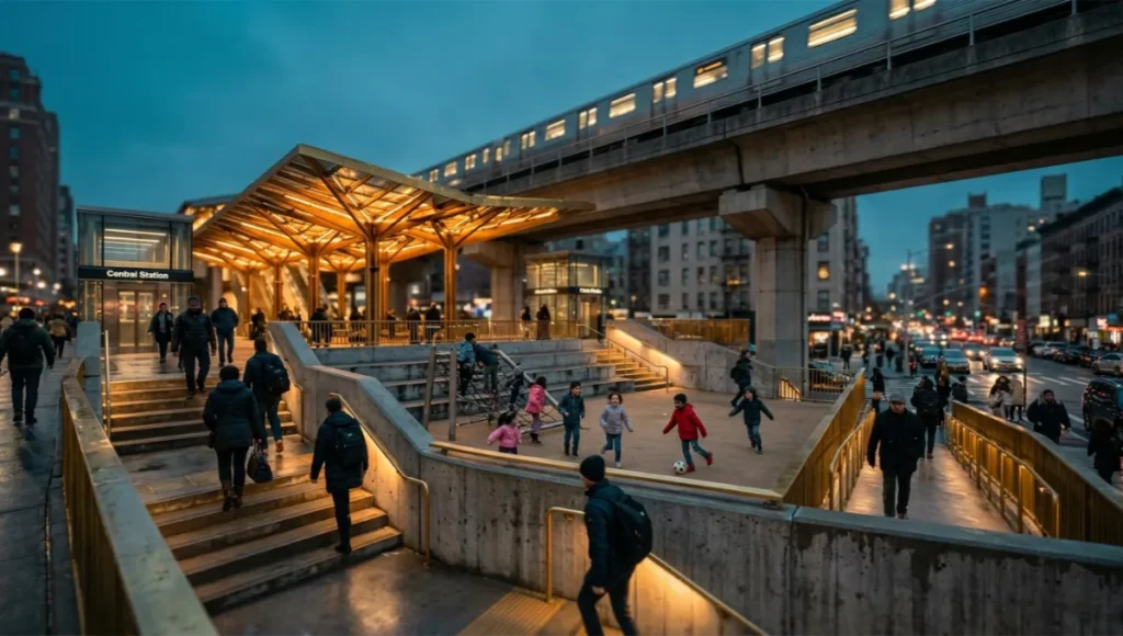
You have been trained to read a city as a circuit diagram: arteries for cars, conduits for pedestrians, and dead air everywhere else. That reading is a failure of imagination dressed up as efficiency. Walk any arterial boulevard at four in the afternoon and you will see the evidence — bodies moving with the grim choreography of people who have somewhere to be and nowhere to linger.
Playable cities urban design rejects that choreography outright. It asks you to treat the sidewalk, the transit plaza, the leftover triangle of asphalt behind a parking structure, as latent civic infrastructure rather than dead space awaiting a use permit. This is not a beautification exercise. It is a structural argument about who a street is built to serve, and what happens to a population’s social cohesion when every public surface is engineered exclusively for throughput.
The dystopian version of this story is already familiar to you, even if you have never named it. It is the housing block with a perimeter fence around its only green courtyard. It is the transit plaza with no seating, because seating reads as an invitation to loiter, and loitering reads as a liability. It is the entire discipline of hostile architecture — the spikes under a ledge, the deliberately sloped sill, the bench arm placed to prevent lying down — dressed up in the language of safety while actually optimizing for the absence of the public. You have walked through cities built on this logic without being told its name. Naming it is the first act of resistance.
Nuvira Perspective
At Nuvira Space, our research division does not categorize play as an amenity line-item appended to a master plan once the structural decisions are already locked. We treat it as one of three load-bearing systems — alongside mobility and ecology — that determine whether a neighborhood metabolizes its own density or simply endures it. This is the foundation of what we call human-machine synthesis: the deliberate recalibration of the metropolitan fabric so that sensor networks, adaptive surfaces, and embedded data infrastructure serve the body’s need for spontaneous, low-stakes interaction, not only the vehicle’s need for unobstructed flow.
A bus shelter that logs dwell time is not inherently playful. A bus shelter that logs dwell time and uses it to trigger a responsive light pattern — inviting two strangers to glance at each other and smile — has crossed into civic instrumentation with sociological intent. That distinction, instrumentation in service of human contact rather than surveillance in service of optimization alone, is the line Nuvira Space designs against.
We make this argument specifically through transit-oriented development because that is where the societal value is easiest to measure and hardest to ignore. A station plaza is, by definition, the highest-dwell-time public surface in any neighborhood it serves; everyone passes through it, and a meaningful share of riders wait there involuntarily for several minutes at a time. Treating that involuntary wait as an opportunity for resilient, sociable infrastructure — rather than as dead time to be minimized through faster headways alone — converts a transit investment into a neighborhood investment without spending a second dollar on land.
The “Blueprint” Solution
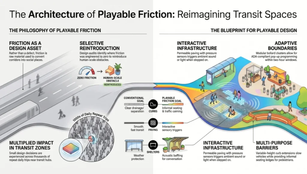
Reading Friction as a Design Asset
Conventional traffic engineering treats friction — anything that slows a body’s progress through space — as a defect to be designed out. Playable cities urban design treats friction as raw material: a slight obstacle, a change in texture, a reason to pause, is precisely what converts a transit corridor into a place where people recognize their neighbors.
The blueprint starts by auditing where friction has been engineered to zero, then selectively reintroducing it at human scale, never at a scale that compromises accessibility or emergency access. Near a transit-oriented development site specifically, this audit matters more than almost anywhere else in a city, because a station catchment area concentrates more daily pedestrian volume into a smaller radius than any other land use, which means small frictional decisions there are multiplied across thousands of repeat trips rather than experienced once.
- Variable-height curb extensions (4–8 in.) at mid-block crossings, slowing vehicle approach speed while doubling as informal seating ledges
- Permeable paving zones with embedded pressure sensors that trigger ambient sound or light when stepped on in sequence
- Modular bollard clusters rated for ADA clearance, repositionable within a two-hour maintenance window for pop-up programming
- Acoustic baffling integrated into transit shelter roofs, cutting ambient road noise enough to make conversational volume viable at the curb
Sensory and Tactile Layering
This is where resilient infrastructure and play stop being separate budget lines. A permeable play surface that also functions as a bioswale during a storm event is not a compromise between departments; it is the only fiscally defensible version of either intervention on its own. Layering sensory cues for different ages and abilities onto the same surface multiplies the return on a single capital outlay rather than fragmenting it across competing requests.
- Recycled rubber-aggregate surfacing with high infiltration rates, doubling as stormwater attenuation during peak rainfall
- Shade canopy structures using kinetic textile elements that flex with wind load, reducing surface temperature in summer months
- Tactile wayfinding strips embedded at decision points, serving low-vision pedestrians and children’s wayfinding games simultaneously
- Low-frequency haptic paving panels near transit doors, cueing boarding sequence without relying on auditory announcements
Governance and Maintenance Mechanics
None of this survives first contact with a municipal budget cycle without a governance model built for it. A kinetic canopy that nobody owns after the ribbon-cutting becomes a liability inside eighteen months, and a sensor network with no data-retention policy becomes a political problem long before it becomes a maintenance one. The blueprint requires two separate mechanisms working together: a contract structure that assigns ownership of every moving part before installation, and a transparency mechanism that earns public trust before a single complaint forces the issue.
Contract Structure
Most cities are still missing the procurement language for this — specifically, the clause separating who owns a static paving surface from who owns the sensor embedded inside it, since these are rarely the same vendor and almost never the same department.
- Tiered maintenance contracts separating high-wear kinetic elements from static structural components
- Vendor service-level agreements with response-time penalties scaled to the safety relevance of the failed component
Transparency and Renewal
A sensor network installed to measure dwell time or footfall will eventually be asked, by a resident or a journalist, what else it measures. The honest answer should already be public before the question is asked.
- Sensor-data dashboards published on a delay, building public trust without exposing real-time individual movement patterns
- Community stewardship agreements assigning adjacent property owners a defined seasonal upkeep role
- Mandatory programming review every 24 months to retire underused elements before they become deferred-maintenance liabilities
Feasibility Study: Economic and Political Barriers
The contradiction at the center of this entire proposition is that the retrofit cost is frequently lower than the political cost. A city can fund a permeable play plaza for a fraction of a parking structure, yet the plaza proposal will face a harder council vote. Understanding why requires separating the economic friction from the political friction, because they are solved by entirely different instruments — a financing tool will not resolve a credibility problem, and a demonstration project will not resolve a budget-allocation problem. Treating the two as a single feasibility question is the single most common reason these proposals stall in committee rather than at the design table.
Economic Barriers
Capital cost for most playable infrastructure interventions is modest relative to standard roadworks; the resistance comes from where that cost sits on a balance sheet. Parks departments rarely control stormwater budgets, transit agencies rarely control sidewalk budgets, and a project that needs all three to function well gets stalled waiting for a single department to claim full ownership of a shared expense. Add the perceived liability exposure of novel street furniture — insurers are conservative about anything that moves, lights up, or invites climbing — and a project with strong long-term returns can stall at the procurement stage before a shovel ever touches ground.
A handful of cities have broken this deadlock through value capture financing, tying a portion of the uplift in adjacent property value directly back to the public realm budget that created it. Without a mechanism like this, the agency that bears the construction cost is rarely the agency that captures the long-term benefit, and that mismatch alone kills more proposals than any technical objection does.
Political Barriers
An elected official’s term rarely outlasts the payback period on infrastructure that pays off through reduced collision rates, lower stormwater capital expenditure, and incremental transit ridership gains measured over a decade. That mismatch pushes officials toward visible, immediately legible spending and away from anything that reads, at a glance, as frivolous. Add legitimate equity concerns — amenities of this kind have a documented tendency to cluster first in already-affluent districts — and a well-intentioned proposal can collect opposition from both fiscal conservatives and equity advocates simultaneously.
The workaround that has proven most durable borrows directly from tactical urbanism neighborhood projects: a temporary, reversible installation, often called a demonstration permit, that lets a council see the social outcome before being asked to vote on a permanent capital commitment. AIA New York has chronicled this same pattern across a decade of pilots: a short, low-cost installation tends to build the political consensus that a rendering alone rarely can. A demonstration permit also gives an equity argument somewhere concrete to land — a pilot can be sited deliberately in an underserved district first, reversing the usual order in which amenities reach affluent neighborhoods before anywhere else.
Proof of Concept: Rotterdam, Copenhagen, and Singapore
Three cities, three governance models, three climates. None of them share a population size, a political system, or an annual rainfall total, and that is precisely why they are useful evidence rather than a single climate’s luxury.
Rotterdam: The Water Square as Civic Infrastructure
Rotterdam’s Benthemplein Water Square, designed by De Urbanisten, sinks a basketball court and skate terrain below street level so that the same geometry which makes it an appealing place to gather also makes it an effective stormwater retention basin during peak rainfall. The square was funded in part through the city’s water authority budget rather than its parks budget — a governance decision as significant as the design itself, because it proved a single capital outlay could satisfy two agencies’ mandates at once rather than forcing a competition between them.
Copenhagen: Superkilen and the Politics of Identity in Play
Copenhagen’s Superkilen park, designed by BIG, Topotek1, and Superflex through the Nørrebro neighborhood, assembled play objects and street furniture sourced from countries represented in the surrounding immigrant population — a Thai boxing ring marker, Moroccan fountain tiles, a Japanese octopus slide. The sociological intent was explicit: play infrastructure as a tool of cultural recognition, not a neutral backdrop to it. Copenhagen has paired this with cloudburst streets elsewhere in the city, where the same terraced geometry that channels stormwater during a downpour functions as informal seating and play terrain the rest of the year.
Singapore: Naturalizing the Drainage Channel
Singapore’s Bishan–Ang Mo Kio Park naturalized a stretch of the Kallang River that had previously been a straight concrete drainage canal, replacing it with a meandering channel and terraced banks built jointly by the national water agency and the parks authority. The terraces increase flood conveyance capacity during heavy storms while functioning, on an ordinary afternoon, as informal gathering and play terrain for the housing estates on either bank. The lesson here is procedural as much as material: the naturalization only happened because two agencies with historically separate mandates agreed to co-author a single brief.
Set side by side, these three projects make the same argument from three different starting conditions: a dense, low-lying European delta city facing chronic flood pressure; a Nordic capital managing the cultural integration of a rapidly diversifying population; and a tropical island state where land is the scarcest input of all. None of them treated play as a separable line item, and none of them needed a novel funding mechanism so much as a willingness to let two existing budgets sign the same brief.
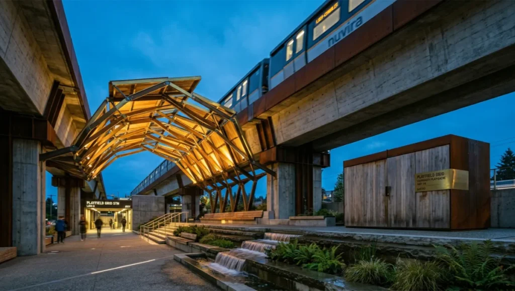
Concept Project Spotlight — Speculative / Internal Concept Study: PLAYFIELD GRID by Nuvira Space
Project Overview (Location / Typology / Vision)
Location: a composite mid-density transit corridor, modeled on a secondary commuter rail line through a temperate coastal city, used here as a generalized testbed rather than a site-specific proposal. Typology: a 1.2-kilometer at-grade and elevated transit corridor retrofit connecting four station plazas currently treated as pass-through space. Vision: a continuous “play spine” linking the four plazas without requiring the acquisition of a single new parcel of land — the entire concept operates inside existing transit easements and underused setback zones. The corridor was deliberately chosen for its ordinariness: no waterfront, no flagship civic building, nothing that would make the intervention easy to dismiss as site-specific good fortune.
Design Levers Applied
Each lever below is drawn directly from the Blueprint Solution principles above, applied specifically to the constraints of a linear transit easement rather than a discrete plaza.
- Modular kinetic canopies at each station plaza, functioning as shade structures and wind-responsive sound elements at the same time
- A sensor-triggered paving sequence linking station exits to adjacent retail frontage, redistributing pedestrian dwell time away from the single congested exit point
- Tiered stormwater terraces beneath elevated track sections, replacing fenced-off drainage easements with floodable, publicly usable terrain
- Community-operated “play caches” — lockable storage units that release loose-parts play equipment during defined after-school hours only, reverting to closed storage outside that window
Transferable Takeaway
The core lesson is portable independent of climate, transit mode, or governance model: an existing transit easement, however marginal it looks on a land-use map, is latent play infrastructure the moment a single agency accepts joint liability for its public use. The capital cost of the PLAYFIELD GRID concept is dominated by governance negotiation, not materials — which means the most replicable part of this study is not the canopy specification or the paving sequence, but the interagency memorandum that let them be installed under one maintenance contract instead of four competing ones.
2030 Future Projection
By the end of this decade, you should expect the distinction between “play infrastructure” and “resilient infrastructure” to collapse in procurement language the same way it has already collapsed in the Rotterdam and Singapore case studies above. Cities that continue to fund these as separate line items will simply build less of both, while cities that merge the request-for-proposals process will out-build them on the same budget. Transit-oriented development plans submitted for funding after 2028 are increasingly likely to require a joint mobility-ecology-play impact statement as a single document, rather than three separate departmental sign-offs submitted on different timelines.
Expect sensor-driven play elements to shift from novelty installations toward standardized municipal product catalogs, the same way bike-share docking stations went from bespoke pilot projects to off-the-shelf procurement within a single decade. Standardization is the trend line worth watching most closely, because it is what allows a tactic proven in one city to be specified, rather than reinvented, in the next one.
The cities that move fastest will not be the wealthiest ones. They will be the ones whose water authority, transit agency, and parks department already share a procurement office, because the binding constraint by 2030 will not be capital availability — it will be the number of cities that have rewritten their internal approval workflow ahead of the technology becoming commodity-priced. Treat that workflow rewrite as the actual infrastructure project, and the canopy, the paving, and the sensors as comparatively minor line items beneath it.
Comprehensive Technical FAQ
Q: What is the typical capital cost difference between a conventional plaza retrofit and a playable cities urban design retrofit of the same footprint?
A: The material cost premium is usually modest — sensor-embedded paving and kinetic shade elements add to a baseline plaza budget, but rarely double it. The larger cost variable is governance overhead: coordinating between agencies typically adds more to a project’s timeline and soft costs than the hardware itself. A project scoped from the outset as a joint mobility-ecology-play brief, rather than three sequential approvals, will almost always show a lower effective cost per square meter than the same elements added piecemeal after a conventional plaza design is already locked.
Q: Do permeable, sensor-embedded surfaces require specialized maintenance crews?
A: Partially. Static permeable paving uses the same maintenance skillset as conventional permeable pavement. Kinetic and sensor-driven elements require a dedicated low-voltage maintenance contract, which is why tiering the maintenance agreement — separating moving parts from static surfaces — is one of the governance levers covered in the Blueprint Solution above.
Q: How is accessibility preserved when friction is intentionally reintroduced into a streetscape?
A: Friction elements are scaled and positioned to remain outside the primary accessible path of travel, with continuous, code-compliant clearance maintained alongside any curb extension, bollard cluster, or textured paving zone. Key specifications to verify on any proposal include:
- A minimum 36-inch continuous accessible path of travel free of any friction element
- Tactile paving used for wayfinding meets, rather than conflicts with, ADA detectable-warning standards
- Curb extension heights kept within ranges that do not compromise wheelchair or mobility-device clearance
- Acoustic and sensory elements designed with an off-switch or quiet-hours setting for nearby residents with sensory sensitivities
Q: Can a playable cities approach be retrofitted onto an existing transit corridor without a full street reconstruction?
A: Yes — the PLAYFIELD GRID concept above is built specifically on that premise, working within existing easements rather than requiring new land acquisition or full-depth street reconstruction.
Q: How should a city measure success after installation, beyond a one-time ribbon-cutting headcount?
A: Dwell time and repeat-visit frequency are more durable indicators than a single opening-day attendance figure, since novelty foot traffic fades within a few months regardless of design quality. A credible monitoring plan should specify the following before installation, not after:
- A baseline pedestrian count taken before construction begins, for genuine before-and-after comparison
- Quarterly dwell-time sampling at consistent times of day across at least one full seasonal cycle
- A qualitative survey component, since sensor data alone cannot capture whether an interaction felt meaningful to the people having it
Q: What happens to these installations during extreme weather events?
A: Properly specified elements are designed to fail toward their resilient function first. A stormwater terrace that doubles as seating should flood completely and safely rather than partially, and kinetic canopies should have a documented wind-load shutdown threshold rather than an assumption that they simply will not be tested by a storm severe enough to matter.
Conclusion
You do not need a new parcel of land, a referendum, or a decade-long capital program to begin. You need one agency willing to co-author a single brief with another, one underused easement, and a maintenance contract that treats kinetic infrastructure as seriously as it treats a traffic signal. The hardest part of this work is never the canopy specification or the paving sequence — both are solved problems, demonstrated already in Rotterdam, Copenhagen, and Singapore. The hardest part is the first interagency memorandum, and it only has to be written once before it becomes a template.
Nuvira Space develops feasibility frameworks, governance templates, and concept studies for cities and transit agencies ready to treat play as load-bearing civic infrastructure rather than an amenity line-item. If your jurisdiction is starting from a blank plaza rather than a transit easement, our inclusive public park design guide is the more useful starting brief. If your jurisdiction has a corridor, a plaza, or an easement that already meets people halfway, bring it to us. We will tell you, plainly, whether it is ready.
© Nuvira Space. All rights reserved. | URBAN PULSE Series | All specifications cited are based on publicly documented urban design case studies (Rotterdam, Copenhagen, Singapore) and Nuvira Space's internal speculative design framework. External sources are linked at point of reference. The PLAYFIELD GRID is a speculative internal concept study and does not represent a completed project.