

Table of Contents
Key Takeaways
- Copenhagen bicycle infrastructure design operates not as isolated engineering but as a calibrated metropolitan organism—where 560 km of fully separated cycle tracks function as the arterial system of civic life.
- The city’s 2026 iteration proves that transit-oriented development succeeds only when infrastructure is treated as spatial choreography, not mere mobility hardware.
- Data-driven signal intelligence—optimizing 97% of intersections for cyclist priority—demonstrates that resilient infrastructure is fundamentally a behavioral technology.
- Macro-environmental gains are inseparable from micro-scale material decisions: 2.5m minimum track widths, corten steel bridges, and permeable pavement with 85mm concrete blocks.
- The Copenhagen model is replicable, not exceptional—its methodology transfers to Rotterdam, Singapore, and Tokyo through recalibrated density thresholds and political will.
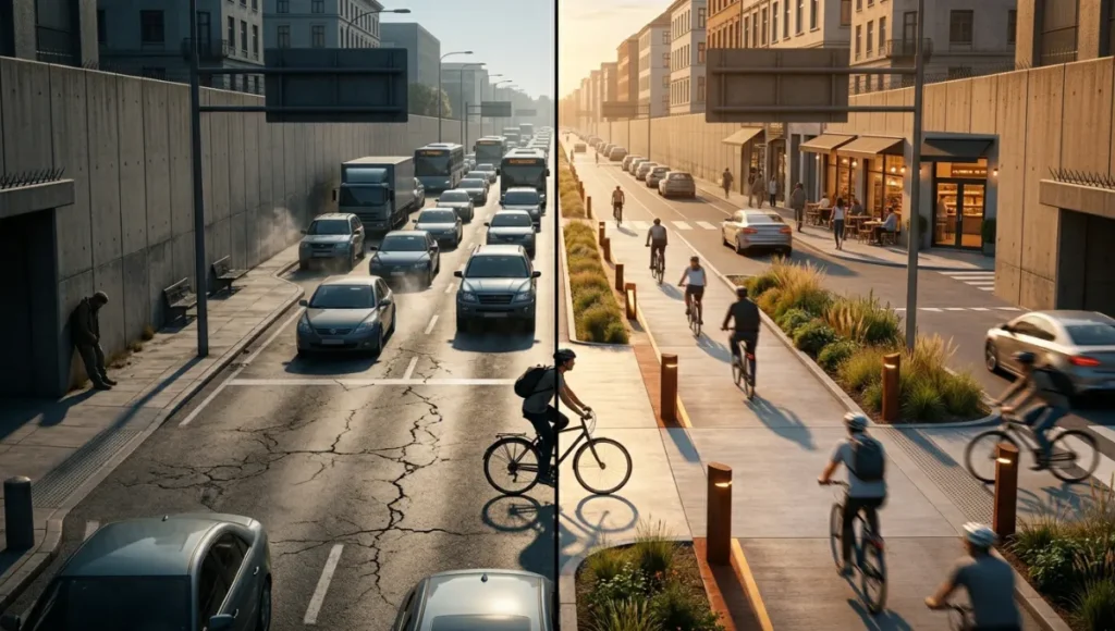
You stand at the edge of a metropolitan intersection at rush hour. Around you, the city groans—steel boxes idling in thermal agony, asphalt radiating stored heat back into the lungs of pedestrians, a sonic landscape of horns and compression brakes that no urban planner would willingly call home. This is the dystopian reality that current city planning has normalized: mobility as extraction, streets as throughput machines, humans as cargo. But what if the metropolis were recalibrated—not as a machine for moving cars, but as an organism for sustaining life?
Copenhagen bicycle infrastructure design offers not an escape from this question, but a rigorous, replicable methodology for answering it. The city did not stumble into its status as the world’s most bicycle-friendly capital. It engineered it, block by block, signal by signal, material by material, over five decades of deliberate, data-driven urban transformation. And in 2026, that methodology has matured into something far more potent than infrastructure: it has become a civic technology.
Nuvira Perspective
At Nuvira Space, we do not view cities as collections of buildings and roads. We understand them as complex adaptive systems—metropolitan fabrics woven from human behavior, material performance, and data intelligence. Our work sits at the intersection of urbanism and machine learning, where transit-oriented development is not a planning buzzword but a computational discipline. Copenhagen bicycle infrastructure design exemplifies the principles we champion: the recalibration of public space through evidence-based intervention, the elevation of non-motorized mobility to primary-tier status, and the recognition that resilient infrastructure must perform across temporal scales—from the daily commute to the climate century.
The city’s 2026 infrastructure matrix—560 km of fully separated, two-way cycle tracks, signal intelligence optimizing 97% of intersections, and a 28% reduction in heavy goods vehicle entry since 2018—represents what we term human-machine synthesis: the seamless integration of civic behavior, spatial design, and real-time data feedback. This is not utopian speculation. It is operational reality. And it is the standard against which we measure every metropolitan intervention we undertake.
The Blueprint: Copenhagen Bicycle Infrastructure Design as Civic Technology
To understand Copenhagen bicycle infrastructure design is to abandon the notion that bike lanes are accessories to road networks. In Copenhagen, cycling infrastructure is the primary circulatory system of the city. The 2026 configuration reveals five interconnected design levers that transform mobility from a utilitarian function into a civic experience.
Spatial Choreography: The Geometry of Flow
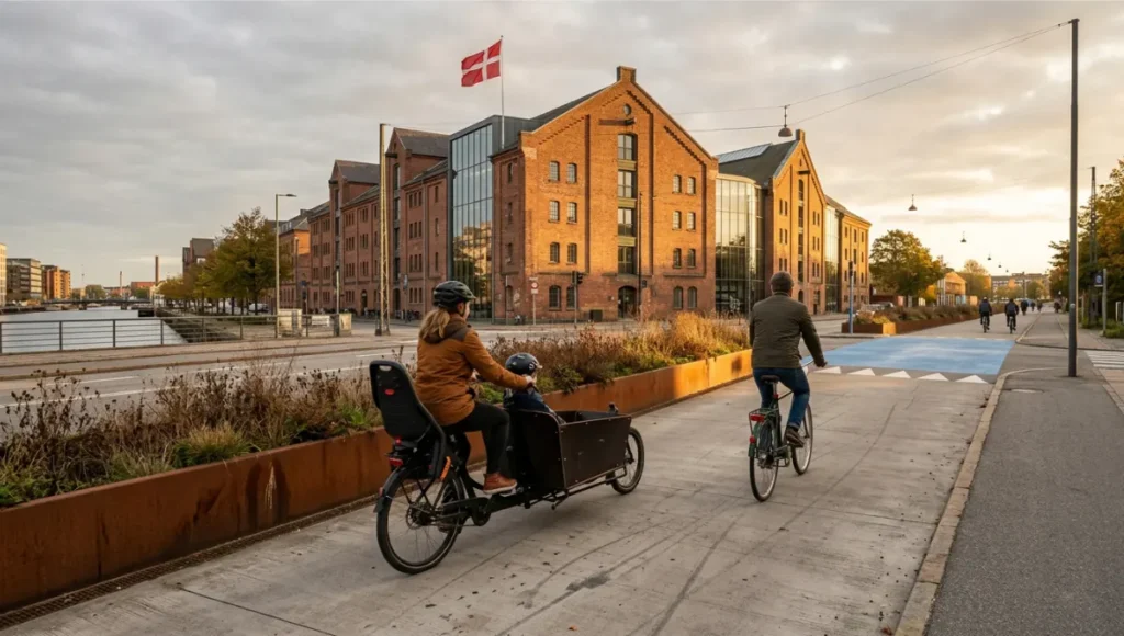
You do not ride through Copenhagen. You glide through it. The city’s cycle tracks are not painted lines appended to carriageways; they are fully separated, two-way corridors with a minimum width of 2.5 meters per direction. This dimension is not arbitrary. It accommodates side-by-side cycling—critical for social transit, parent-child transport, and cargo bike maneuvering—while maintaining safe overtaking distances. The longitudinal surface tolerance is held to ±3mm, ensuring that vibration does not fatigue the rider over distance.
At intersections, the geometry shifts from linear to calibrated. Raised cycle tables—flush with the sidewalk, not the road—create tactile and visual continuity that signals priority without signage. The curb radius at turning points is tightened to 5 meters, forcing motor vehicles to decelerate to cycling speed. Shark-tooth road markings and blue-painted conflict zones provide redundant visual cues. This is not traffic calming. It is spatial legislation: the street itself enforces the hierarchy of movement.
Material Intelligence: Surfaces That Perform
The material palette of Copenhagen bicycle infrastructure design is deliberately constrained and rigorously tested. Cycle tracks utilize brushed concrete with a bi-directional texture that provides grip in wet conditions without inducing directional drag. Permeable pavement—85mm concrete blocks with 4mm open joints—allows stormwater infiltration at rates exceeding 1,000 mm/hour, reducing runoff loads on combined sewer systems by an estimated 34% in high-cycling districts.
Bridge infrastructure reveals the city’s material ambition. The Cykelslangen—Copenhagen’s “Cycle Snake”—is a 230-meter elevated cycle track of corten steel and brushed aluminum that carries cyclists seven meters above the harbor. The weathering steel develops a stable oxide patina that requires zero maintenance over a 50-year design life. The deck surface integrates heated elements at entry points to prevent ice formation, extending the operational season into January and February when conventional infrastructure would close.
Technical Specifications — Copenhagen 2026 Cycle Network
- Total separated cycle track length: 560 km (two-way, fully grade-separated where feasible)
- Minimum track width per direction: 2.5m (3.0m on arterial corridors)
- Surface longitudinal tolerance: ±3mm over 3m straightedge
- Permeable pavement infiltration rate: >1,000 mm/hour
- Signalized intersections with cyclist priority: 97% of network
- Cyclist head start at signals: 4 seconds (green wave offset)
- Heavy goods vehicle entry reduction (inner city): 28% since 2018
- Average cycling speed: 16 km/h (design standard for intersection timing)
- Cargo bike loading bay provision: 1 per 150m in commercial districts
- Heated surface integration: bridge entry/exit points, 0°C activation threshold
Signal Intelligence: The Algorithmic City
Perhaps the most radical dimension of Copenhagen bicycle infrastructure design is invisible. The city’s signal network operates as a distributed intelligence system. Inductive loops, radar sensors, and Bluetooth beacons detect cyclist density and velocity in real time. Traffic signals are not timed; they are negotiated. A cyclist approaching at 16 km/h triggers a green wave that propagates backward through the corridor, holding subsequent signals green until the platoon passes.
At 97% of signalized intersections, cyclists receive a 4-second head start before motor vehicles receive green. This temporal separation eliminates right-hook conflicts—the most common cause of cyclist fatalities in mixed-traffic environments. The system does not merely manage flow; it allocates risk. And it does so without human intervention, learning from daily patterns and adjusting to weather, events, and construction disruptions. This is resilient infrastructure as behavioral technology: it shapes movement by shaping decision architecture.
Transit-Oriented Development: Density Without Displacement
Copenhagen bicycle infrastructure design is inseparable from the city’s transit-oriented development strategy. The Finger Plan—first conceived in 1947 and continuously updated—directs growth along five radial corridors served by S-train lines and cycle superhighways. New residential construction within 600 meters of these corridors receives density bonuses that would be politically impossible in auto-centric contexts. The result is a metropolitan form that concentrates population along high-capacity transit spines while preserving green wedges between fingers.
Crucially, this density is not accompanied by displacement. The city’s 2026 affordable housing mandate requires that 25% of units in new transit-oriented developments be price-controlled, with priority allocation for families dependent on cycling for daily mobility. This is not charity. It is structural recognition that transit-oriented development fails if it prices out the population it purports to serve. Copenhagen bicycle infrastructure design is thus a social technology as much as a physical one: it distributes access, not just asphalt.
Feasibility Study: Economic and Political Barriers
The replication of Copenhagen bicycle infrastructure design is not constrained by engineering. It is constrained by political economy. Any city contemplating this transformation must confront three categories of barrier: fiscal, institutional, and cultural.
Economic Barriers: The True Cost of Cheap Infrastructure
The upfront capital cost of Copenhagen-grade cycle infrastructure is substantial. Fully separated cycle tracks cost approximately €2.5–€4.0 million per kilometer, depending on drainage, lighting, and bridge integration. Signal intelligence systems add €150,000–€300,000 per intersection. For a city like Rotterdam—comparable in size and density to Copenhagen—a full network build-out would require €1.2–€1.8 billion over 15 years.
But the economic calculus shifts when lifecycle costs are included. Copenhagen’s cycling network generates a net positive return of €0.16 per kilometer cycled, accounting for reduced healthcare expenditure, lower road maintenance, decreased congestion, and productivity gains from reliable commute times. Over a 20-year horizon, the network pays for itself 2.3 times over. The barrier is not cost. It is accounting methodology: most municipal budgets separate capital expenditure from operational savings, preventing the integrated financial planning that Copenhagen bicycle infrastructure design demands.
Political Barriers: The Tyranny of the Status Quo
The deeper obstacle is institutional inertia. Auto-centric cities have spent seven decades optimizing for a single mode. Road departments measure success in vehicle level of service. Traffic engineers are trained in throughput maximization. Zoning codes mandate parking minimums that subsidize car ownership. Reversing this requires not policy change but institutional reconstitution: new performance metrics, new professional training, new procurement standards.
Copenhagen itself required three political generations to achieve its current configuration. The 1970s oil crisis provided the initial shock. The 1990s environmental movement sustained momentum. The 2010s data revolution provided the tools for optimization. The lesson is not that Copenhagen bicycle infrastructure design is unattainable elsewhere. It is that it requires sustained political will across electoral cycles—a commodity rarer than funding. Cities that succeed will be those that insulate infrastructure planning from partisan turnover through independent metropolitan authorities with multi-decade mandates.
Proof of Concept: Global Transferability
Copenhagen bicycle infrastructure design is not a Nordic anomaly. Its principles are already transferring to cities with radically different climatic, topographical, and political contexts.
Singapore: Tropical Density Meets Cycle Logistics
Singapore’s tropical climate presents a formidable challenge: cycling in 32°C heat with 85% humidity is not a leisure activity; it is an endurance sport. Yet the city-state has adapted Copenhagen bicycle infrastructure design principles to its context. The Park Connector Network—currently 380 km and expanding to 500 km by 2030—utilizes shaded corridors with integrated misting systems and solar-panel canopies that reduce perceived temperature by 4–6°C. Signal timing is adjusted for lower average cycling speeds (12 km/h in tropical conditions vs. 16 km/h in Copenhagen). Cargo bike logistics—critical for last-mile delivery in dense urban cores—are prioritized with dedicated loading infrastructure.
The result is not Copenhagen replicated, but Copenhagen recalibrated. Singapore proves that the methodology—separation, priority, material intelligence, signal optimization—transcends climate. What changes are the parameters, not the principles.
Tokyo: Retrofitting the Megacity
Tokyo presents the opposite challenge: not climate, but scale. The metropolitan region of 37 million inhabitants has a cycling modal share of 14%—already substantial—but infrastructure quality varies dramatically across the 23 wards. The Minato Ward pilot, launched in 2024, applies Copenhagen bicycle infrastructure design principles to a retrofit context: converting 12 km of narrow residential streets into bicycle-priority corridors using modal filters (bollards and planters that permit cycles but exclude through-traffic), raised tables at every intersection, and digital wayfinding integrated with the city’s Suica transit card system.
Early data indicates a 23% increase in cycling trips within the pilot zone and a 31% reduction in cyclist-motorist conflicts. The political lesson is equally significant: Tokyo’s ward-level governance allows experimentation without metropolitan-scale consensus, creating a laboratory model that other megacities can emulate.
Speculative / Internal Concept Study: The Velo-Weave by Nuvira Space
Project Overview: Location / Typology / Vision
The Velo-Weave is a speculative internal concept study by Nuvira Space, developed for a post-industrial waterfront district in Rotterdam, Netherlands. The site—42 hectares of reclaimed port land—presents a rare opportunity: a blank canvas within an existing metropolitan fabric. The vision is not to build bike lanes, but to weave cycling into the DNA of urban form.
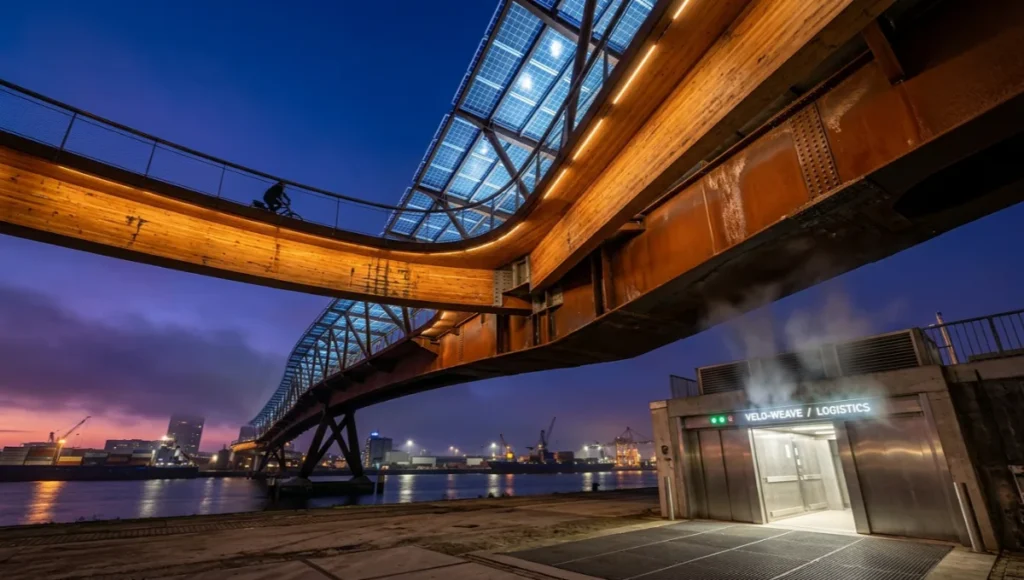
The Velo-Weave proposes a three-dimensional cycle network that operates at grade, elevated, and subterranean levels. At grade, 8-meter-wide bi-directional cycle boulevards function as the primary public space—lined with commercial frontage, stormwater gardens, and photovoltaic canopy structures. Elevated cycle viaducts—constructed from cross-laminated timber and recycled steel—connect district nodes at heights of 6–12 meters, offering panoramic views of the harbor while eliminating intersection conflicts. A subterranean cycle logistics tunnel—4 meters in diameter, climate-controlled, and served by automated cargo bike elevators—handles freight movement, removing delivery vehicles from surface streets entirely.
Design Levers Applied
Spatial Choreography
- Grade-separated intersections: 100% of cycle-motor vehicle crossings
- Minimum cycle boulevard width: 8m (accommodating side-by-side social cycling + cargo overtaking)
- Curb radii at turning points: 4.5m (tighter than Copenhagen’s 5m, forcing lower vehicle speeds)
- Tactile paving transition zones: 300mm width, detectable under wheel and foot
Material Intelligence
- Cross-laminated timber viaduct decking: FSC-certified, carbon-sequestering, 80-year design life
- Recycled steel superstructure: 60% post-consumer content, weathering steel finish
- Permeable pavement system: 100mm concrete pavers with 5mm joints, infiltration rate >1,200 mm/hour
- Photovoltaic canopy: bifacial panels generating 180 kWh/m²/year, shading coefficient 0.65
Signal Intelligence
- AI-driven signal optimization: machine learning model trained on 5 years of Copenhagen, Singapore, and Tokyo data
- Predictive cyclist detection: thermal imaging + LiDAR, 150m upstream of intersections
- Dynamic green wave: speed-adjusted to individual cyclist velocity (10–20 km/h range)
- Emergency vehicle preemption: sub-10-second clearance protocol without cyclist dismount
Transit-Oriented Development
- Mixed-use density: FAR 4.5 within 400m of cycle boulevards, 30% affordable housing mandate
- Zero parking minimums: maximum 0.3 spaces per residential unit, all priced at market rate
- Cargo bike logistics hubs: 1 per 200m in commercial zones, with cold storage and charging
- Vertical cycling towers: automated bike parking structures with 500-unit capacity, 45-second retrieval
Transferable Takeaway
The Velo-Weave demonstrates that Copenhagen bicycle infrastructure design principles scale vertically and horizontally. The transferable insight is dimensional: cycling infrastructure need not compete for surface area if it is designed as a three-dimensional system. The subterranean logistics tunnel—removing freight from streets—is applicable to any dense district with port or industrial heritage. The elevated timber viaducts—creating new public realms above existing congestion—offer a retrofit strategy for cities where surface space is already contested. And the photovoltaic canopies—generating energy while sheltering cyclists—address the energy-climate nexus that Copenhagen’s original design did not explicitly confront.
2030 Future Projection
By 2030, Copenhagen bicycle infrastructure design will have evolved from a municipal achievement to a global standard. We project four convergent trends.
First, the integration of autonomous vehicle networks will force a recalibration of street hierarchy. As self-driving taxis and delivery pods proliferate, the separation of human-powered and machine-powered mobility will become a safety imperative, not a lifestyle choice. Copenhagen’s fully separated network provides the template: physical segregation, not digital coordination, is the only reliable safeguard.
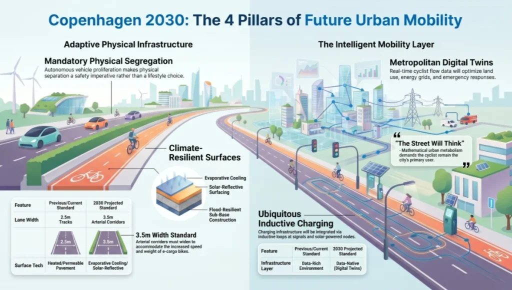
Second, climate adaptation will demand infrastructure that performs under extreme weather. The 2026 Copenhagen network already integrates heated surfaces and permeable pavement; by 2030, we anticipate evaporative cooling systems, solar-reflective surfacing, and flood-resilient sub-base construction becoming standard across Nordic and temperate cities.
For a deeper analysis of climate-adaptive urban water management, see our guide on sponge city infrastructure.
Third, the electrification of cycling—e-bikes, e-cargo bikes, and micro-mobility platforms—will increase average speeds and vehicle weights. Copenhagen’s 2.5m track widths will become the global minimum; 3.5m will be the new standard for arterial corridors. Charging infrastructure—inductive loops at signals, solar-powered stations at nodes—will be as ubiquitous as bike parking.
Fourth, and most significantly, the data layer will become as critical as the physical layer. Real-time cyclist flow data, aggregated and anonymized, will feed into metropolitan digital twins that optimize not just traffic signals but land use, energy grids, and emergency response. Copenhagen bicycle infrastructure design is already a data-rich environment; by 2030, it will be a data-native environment. The street will think. The city will learn. And the cyclist will remain the primary user—not because of ideology, but because the mathematics of efficient urban metabolism demands it.
Explore how real-time building data integration transforms urban operations in our analysis of digital twin building management.
Comprehensive Technical FAQ
Q: What is the minimum viable width for a separated cycle track?
A: Copenhagen bicycle infrastructure design specifies 2.5 meters per direction as the absolute minimum for safe, comfortable cycling. This width accommodates:
- Side-by-side cycling (social transit, parent-child transport)
- Safe overtaking at 16 km/h design speed
- Cargo bike maneuvering (width: 0.9m, turning radius: 2.8m)
- Emergency stopping distance: 4.5m at 20 km/h on dry surface
For global economic validation of cycling infrastructure returns, refer to the World Bank CyclingMax investment framework developed in partnership with ITDP.
Q: How does signal intelligence improve cyclist safety?
A: Copenhagen’s signal network employs three safety mechanisms:
- Temporal separation: 4-second cyclist head start eliminates right-hook conflicts
- Green wave optimization: signals hold green for cyclist platoons traveling at 16 km/h
- Predictive detection: thermal and radar sensors identify cyclists 150m upstream, adjusting timing before arrival
Q: What materials are used in Copenhagen cycle track construction?
A: The material specification prioritizes durability, permeability, and tactile feedback:
- Surface: Brushed concrete with bi-directional texture, ±3mm longitudinal tolerance
- Sub-base: 300mm crushed stone with geotextile separation layer
- Drainage: Permeable pavement (85mm concrete blocks, 4mm joints), infiltration >1,000 mm/hour
- Bridges: Corten steel superstructure, brushed aluminum decking, heated entry/exit zones
Q: How does transit-oriented development integrate with cycling infrastructure?
A: Copenhagen’s Finger Plan demonstrates that cycling and rail transit are complementary, not competitive. Cycle superhighways feed S-train stations, with 15,000 bike parking spaces at major nodes. Density bonuses within 600m of transit corridors fund infrastructure, while 25% affordable housing mandates prevent displacement. The result is a metropolitan form where cycling handles the first and last mile, rail handles the middle mile, and the private car is structurally unnecessary.
Q: What is the economic return on cycling infrastructure investment?
A: Copenhagen bicycle infrastructure design generates €0.16 net positive return per kilometer cycled. This includes:
- Healthcare savings: reduced cardiovascular disease, diabetes, and depression incidence
- Road maintenance: cycle tracks impose 1/20th the wear of motor vehicle lanes
- Congestion relief: each cyclist removes 0.7 vehicle equivalents from peak-hour traffic
- Productivity: reliable commute times reduce stress-related absenteeism by 12%
Q: Can Copenhagen bicycle infrastructure design work in cities with harsher climates?
A: Yes, with parameter adjustment. Singapore’s tropical adaptation demonstrates that separation and priority principles transfer; only material and climatic systems require modification. Key adaptations include:
- Shaded canopies with integrated misting (reduces perceived temperature 4–6°C)
- Storm-resistant drainage: 1,500 mm/hour infiltration capacity for tropical rainfall
- Anti-fungal surface treatment: prevents algae growth on concrete in high humidity
- Adjusted signal timing: 12 km/h green wave for lower tropical cycling speeds
The Metropolitan Fabric Is Not Fixed. It Is Negotiable.
You have read the evidence. You have seen the specifications. You have understood that Copenhagen bicycle infrastructure design is not a Scandinavian fairy tale but a replicable, data-driven methodology for recalibrating the metropolitan fabric. The question is no longer whether this transformation is possible. The question is whether your city has the institutional courage to begin.
At Nuvira Space, we do not sell visions. We engineer transitions. Our team of urbanists, data scientists, and material specialists works with municipalities, developers, and metropolitan authorities to translate Copenhagen bicycle infrastructure design principles into context-specific interventions. Whether you are retrofitting a 19th-century grid or planning a new district on reclaimed land, we provide the analytical rigor, technical specification, and political strategy to move from aspiration to asphalt.
For a broader framework on reclaiming streets for human-scale movement, explore our principles for pedestrian-first city design.
The dystopian city—idling, radiating, honking—is not inevitable. It is a choice. And choices can be reversed. Contact Nuvira Space today. Let us recalibrate your metropolitan fabric.
© Nuvira Space All rights reserved. | URBAN PULSE Series | All specifications cited are based on City of Copenhagen Cycling Strategy 2026, Danish Road Directorate Technical Standards, and Singapore Land Transport Authority Park Connector Network Guidelines. The Velo-Weave is a speculative internal concept study and does not represent a completed project.