


Table of Contents
You already live inside the opening chapter of climate migration urban planning relocation, even if your zoning map has not yet admitted it. The floodplain overlays, the heat-island advisories, the quiet rewriting of insurance actuarial tables — these are not warnings anymore. They are operating conditions. Somewhere between the last coastal storm surge and the next drought cycle, the population you plan for stopped being the population you will actually serve, and most master plans have not caught up.
Key Takeaways
- Climate migration urban planning relocation is shifting from emergency response to a permanent planning discipline embedded in zoning, infrastructure, and capital budgeting.
- Transit-oriented development and resilient infrastructure are the two levers that convert displacement into deliberate, livable relocation.
- Rotterdam, Singapore, and Tokyo already demonstrate working, exportable models for absorbing climate-driven population movement.
- Political and fiscal resistance — not engineering — remains the primary barrier to scaled relocation planning.
- By 2030, cities that fail to formalize relocation corridors will inherit informal ones instead, at far higher social and financial cost.
Nuvira Perspective
At Nuvira Space, you are not asked to mourn the metropolitan fabric of the twentieth century — you are asked to recalibrate it. Human-machine synthesis is not a marketing phrase here; it is the operational premise behind every projection this brand publishes. Sensor networks, hydrological modeling, and adaptive zoning software now do the work that municipal planning departments once did with paper overlays and static census data, and the difference in resolution is not cosmetic. It is the difference between reacting to a flood and pre-positioning a neighborhood so the flood becomes irrelevant to daily life.
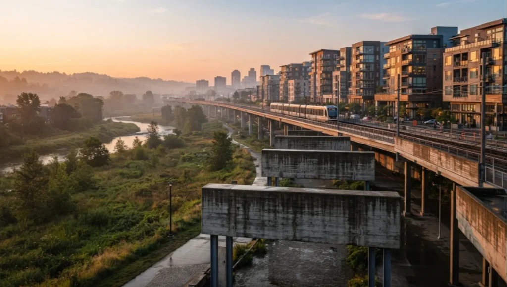
Nuvira Space treats climate migration urban planning relocation as an engineering problem with a sociological payload. The relocation of populations away from fire corridors, storm surge zones, and heat-mortality thresholds is not a humanitarian afterthought bolted onto a masterplan — it is the masterplan. Where legacy planning frameworks treat migration as a demographic input to be absorbed passively, Nuvira’s position is that migration corridors should be designed with the same rigor as a transit line or a stormwater system, because functionally, that is exactly what they are. A city that fails to engineer its relocation pathways will simply inherit informal ones, built without infrastructure, without service access, and without the resilience that formal planning can provide.
This is the recalibration you are being asked to accept: the metropolitan fabric is no longer a fixed grid to be defended at its current coordinates. It is a living system whose load-bearing populations will move, and the only real choice left to a city is whether that movement happens through designed corridors or through chaotic displacement.
Nuvira Space’s editorial position across the Urban Pulse series is that the discipline of urban planning has spent a century optimizing for permanence — permanent zoning categories, permanent infrastructure alignments, permanent assumptions about where population would and would not settle. Climate migration urban planning relocation breaks that premise entirely, and the planners who adapt fastest will be the ones who stop treating impermanence as failure and start treating it as the actual design brief.
The “Blueprint” Solution
Reframing Relocation as Infrastructure
The starting premise of any workable blueprint is that relocation is not a shelter problem, it is a systems problem. You cannot solve climate migration urban planning relocation with temporary housing units dropped at a city’s edge. You solve it by treating population movement the way you would treat a new transit corridor: with capacity modeling, phased investment, and a twenty-year maintenance horizon.
Core Design Levers
The Blueprint approach organizes around four interlocking levers, each with its own technical specification set.
Transit-Oriented Relocation Corridors
- Minimum 15-minute headway rail or BRT spine connecting receiving districts to existing employment centers
- Zoning density gradient of 60–120 dwelling units per hectare within 800 meters of transit nodes
- Mixed-use ground floor allocation of at least 30% to reduce first-mile/last-mile dependency on private vehicles
Resilient Infrastructure Substrate
- Elevated or floating foundation systems in receiving zones below the 100-year floodplain threshold
- Modular utility trenching that allows water, power, and data lines to be relocated without full-street excavation
- Distributed microgrid capacity sized to at least 40% of peak district load, reducing single-point grid failure risk
Adaptive Land-Use Zoning
- Overlay districts that permit density increases contingent on verified climate risk reduction in the sending zone
- Sunset clauses on high-risk zone permits, phased over 10–15 years rather than abrupt condemnation
- Land-value capture mechanisms that redirect appreciation in receiving districts back into relocation financing
Social Infrastructure Parity
- Schools, clinics, and civic space built ahead of, not after, residential occupancy
- Community land trusts or equivalent tenure protections to prevent displacement-by-gentrification in receiving districts
- Cultural continuity programming that preserves social networks disrupted by geographic relocation
Why Sequencing Matters
None of these levers function in isolation. A transit spine without zoning density is an underused rail line. Zoning density without resilient infrastructure substrate is a flood liability with better public transport. The Blueprint’s actual innovation is sequencing: infrastructure and social parity investments precede population arrival by design, rather than trailing it as an afterthought the way most post-disaster relocation has historically operated.
Capital Stacking Across Phases
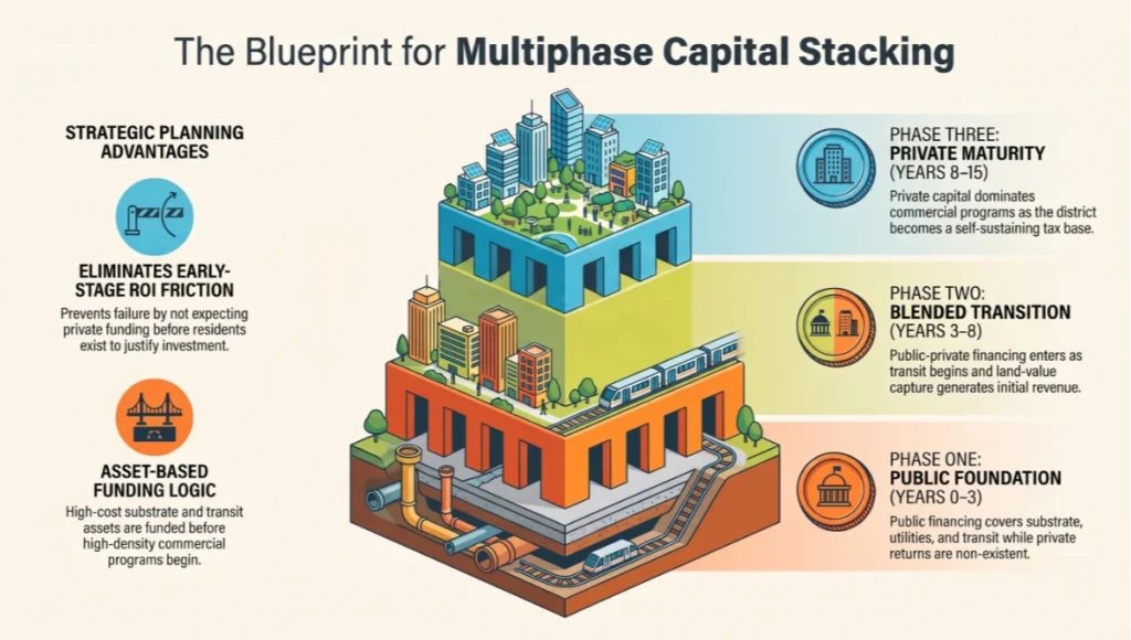
A workable Blueprint also requires an honest accounting of how capital is stacked across a fifteen- to twenty-year build-out. Early phases are almost always subsidized, since receiving districts have no existing tax base to draw from and no proven land-value trajectory to reassure private lenders. Nuvira Space’s modeling treats this as a three-phase capital stack:
- Phase One (Years 0–3): Public and multilateral financing covers substrate, trunk utilities, and the transit spine itself, since these assets have no private return until density arrives.
- Phase Two (Years 3–8): Blended public-private financing enters once transit service is operating and initial residential blocks are occupied, allowing land-value capture mechanisms to begin generating revenue.
- Phase Three (Years 8–15): Private capital dominates, financing infill density and commercial program as the district matures into a self-sustaining tax base capable of funding its own maintenance cycle.
This staged approach matters because it removes the single most common planning failure in relocation programs: expecting private capital to fund substrate and transit before any resident occupancy exists to justify the investment on standard return timelines.
Feasibility Study: Economic and Political Barriers
The Capital Question
Every credible model of climate migration urban planning relocation collides first with financing, not engineering. Elevated foundations, distributed microgrids, and transit spines are expensive in absolute terms, though considerably cheaper than the compounding cost of repeated disaster recovery in high-risk zones. The barrier is rarely whether the money exists across a metropolitan region’s total capital stock — it is whether that capital can be redirected from maintaining legacy infrastructure in sending zones toward building new infrastructure in receiving zones, a reallocation that almost always meets resistance from constituencies still living, voting, and paying taxes in the sending zone.
Political Incentive Misalignment
Elected officials operate on cycles measured in years; climate migration operates on cycles measured in decades. This mismatch is the single largest non-technical barrier to relocation planning. A mayor who champions a receiving-district investment plan is spending political capital on infrastructure whose benefits will likely be credited to a successor. Meanwhile, any policy that acknowledges a sending zone’s declining habitability is read, correctly or not, as a threat to property values and local tax base — creating strong incentive to delay formal acknowledgment even as informal migration already occurs.
Land Tenure and Displacement Risk
Receiving districts face their own political hazard: the risk that formal investment attracts speculative capital faster than it attracts the populations the investment was designed to serve. Absent land-value capture and community land trust protections, transit-oriented relocation corridors can become gentrification corridors, displacing existing lower-income residents in receiving zones rather than integrating incoming populations — a dynamic explored in more depth in Nuvira’s own comparison of gentrification and urban renewal outcomes.
This is not a hypothetical risk — it has already occurred in several coastal relocation pilot programs where infrastructure preceded protective tenure policy rather than accompanying it. The American Planning Association’s guidance on managed retreat similarly flags inadequate consultation and inequitable decision-making as recurring failure points in relocation programs that skip tenure protections.
Regulatory Fragmentation
Climate migration urban planning relocation rarely respects municipal boundaries, yet almost all zoning and infrastructure authority remains municipally scoped. A sending zone and receiving zone may sit in different jurisdictions with different tax bases, different political leadership, and no shared planning authority. Regional or metropolitan-level relocation authorities, while technically straightforward to design, face significant political resistance from municipalities unwilling to cede zoning autonomy.
Construction Capacity and Labor Constraints
Even where capital and political will align, physical construction capacity is a real constraint that feasibility studies frequently underweight. Elevated foundation systems, distributed microgrid installation, and modular utility trenching all require specialized labor pools that most regions have not scaled to meet relocation-level demand. A metropolitan area attempting to build receiving-district capacity for tens of thousands of residents within a single decade will typically need to import specialized contractors, which raises costs and extends timelines beyond what optimistic financial models assume. Feasibility studies that treat construction capacity as infinitely elastic tend to produce budgets and timelines that collapse under real-world procurement conditions.
Public Perception and the Framing Problem
Finally, feasibility depends heavily on how relocation is framed publicly. Populations in sending zones tend to resist any language implying their neighborhood is being written off, even when the underlying risk data is unambiguous. Populations in receiving zones, meanwhile, often resist framing that casts them as a destination for displaced outsiders rather than partners in a shared regional strategy. Successful programs, including several of the case studies below, have found that framing relocation as infrastructure investment rather than abandonment or displacement substantially reduces political friction on both ends of the corridor.
Proof of Concept: Rotterdam, Singapore, and Tokyo
Rotterdam’s Water-Adaptive Model
Rotterdam has spent over two decades building what amounts to a working laboratory for resilient infrastructure substrate, a model closely aligned with the sponge-city infrastructure approach Nuvira has profiled elsewhere in the Urban Pulse series. Its floating pavilion district and water plazas, designed to hold stormwater during peak events and convert back to public space between them, demonstrate that flood-adaptive infrastructure can be civic amenity rather than defensive liability. The city’s approach treats water not as an enemy to be walled out but as a design constraint to be absorbed, a philosophical shift that underlies the entire Blueprint framework described above. The AIA’s own climate adaptation design resources cite comparable benefit-cost frameworks for evaluating this kind of adaptive infrastructure investment.
Singapore’s Land and Density Discipline
Singapore offers the clearest existing example of transit-oriented density paired with proactive land-use planning at national scale, a case Nuvira has covered directly in its analysis of Singapore’s green urban planning strategy. Its Housing and Development Board towns are built with transit access, social infrastructure, and mixed-income tenure baked in from first occupancy rather than retrofitted. The city-state’s willingness to treat land as a centrally coordinated strategic resource — rather than a purely market-allocated one — has allowed it to sequence infrastructure ahead of population need in a way few democracies with fragmented land ownership can easily replicate, but the sequencing logic itself remains transferable even where the land tenure model is not.
Tokyo’s Distributed Resilience
Tokyo’s seismic and flood resilience investment demonstrates the microgrid and distributed-infrastructure lever at scale. Its distributed water retention systems, underground stormwater cathedrals, and redundant utility networks show how a megacity can harden its substrate against compounding climate and geological risk without abandoning density. The lesson for climate migration urban planning relocation is that resilience and density are not opposing goals; a sufficiently engineered substrate allows receiving districts to absorb population at urban, not suburban, densities.
Synthesizing the Three Models
No single city among Rotterdam, Singapore, and Tokyo offers a complete template on its own, and treating any one of them as a turnkey solution misreads what each actually demonstrates. Rotterdam proves that resilient substrate can double as civic amenity. Singapore proves that centrally sequenced land-use planning can deliver transit and social infrastructure ahead of population need. Tokyo proves that density and resilience are compatible at true megacity scale. Climate migration urban planning relocation, as a discipline, is essentially the work of combining these three proofs of concept into a single receiving-district framework, which is precisely the exercise Nuvira Space undertakes in the concept study below.
Concept Project Spotlight: Speculative / Internal Concept Study — “Meridian Basin” by Nuvira Space
Transit Corridors as Climate Corridors
Transit-oriented development has historically been framed around commute efficiency and emissions reduction. In a climate migration context, the same corridors take on a second function: they become the spine along which new arrivals are distributed, preventing the concentration of displaced populations into a handful of overwhelmed neighborhoods. A corridor designed this way needs:
- Headway intervals under 6 minutes during peak absorption windows, allowing rapid redistribution from arrival hubs to outlying districts
- Station-adjacent land banks reserved for fast-deploy housing, sized at a minimum of 1.5 hectares per major interchange
- Mixed-income zoning overlays within 800 meters of stations, preventing displacement-driven segregation
- Real-time occupancy dashboards feeding transit frequency algorithms, so service scales with population density rather than historical ridership
Copenhagen: Cycling and Transit as Redistribution Tools
Copenhagen’s cycling network functions as a pressure-release valve for its transit system, allowing population redistribution across districts without requiring proportional expansion of rail capacity. The principle transfers directly: a reception district does not need a new metro line on day one if it has high-quality active-mobility connections to stations in adjacent districts. This buys time for heavier infrastructure to be built without forcing new arrivals into isolated, transit-poor housing.
For implementation details on lane geometry, intersection design, and modal-share targets, see Nuvira Space’s Copenhagen bicycle infrastructure design breakdown.
Speculative / Internal Concept Study: “Tidal Commons” by Nuvira Space
Project Overview
Location: A composite inland river-basin site, modeled on mid-latitude temperate floodplain conditions
Typology: Mixed-use transit-oriented receiving district, phased for 45,000 residents over 15 years
Vision: Meridian Basin is Nuvira Space’s internal concept study for a purpose-built receiving district designed from inception to absorb climate-displaced population from a hypothetical adjacent coastal metro, rather than retrofitting migration capacity into existing suburban fabric.

Design Levers Applied
- Elevated podium construction across the entire district, holding ground-floor program above the 200-year floodplain line
- A single BRT spine with 8-minute peak headways connecting Meridian Basin to the regional employment core in under 25 minutes
- Distributed microgrid architecture sized to 55% of peak load, exceeding the Blueprint’s baseline resilience threshold
- Community land trust ownership structure applied to 40% of residential parcels at first occupancy, not retrofitted after speculative pressure emerges
- Phased social infrastructure delivery: schools and a primary health clinic completed before the first residential block reaches occupancy
Transferable Takeaway
Meridian Basin’s core lesson is sequencing discipline: every lever in the Blueprint — transit, resilient substrate, adaptive zoning, and social infrastructure parity — was funded and built in a fixed order, with social and transit infrastructure preceding rather than following residential density. Any city attempting climate migration urban planning relocation without this sequencing risks building housing capacity that arrives disconnected from the transit, utility, and civic infrastructure needed to make that capacity genuinely livable.
2030 Future Projection
By 2030, expect the language around climate migration urban planning relocation to shift from voluntary pilot programs to codified regional planning mandates in a growing number of coastal and flood-exposed metropolitan regions. Insurance markets are already pricing risk in ways that will make continued occupancy of the highest-risk zones financially untenable for a meaningful share of current residents well before any formal relocation policy forces the issue. Cities that have not pre-positioned receiving-district infrastructure by that point will face a familiar and costly pattern: population movement that happens anyway, absorbed by whatever housing stock is cheapest and least regulated, typically the least resilient and least transit-connected fringe development available.
The more forward-positioned metropolitan regions will instead have regional relocation authorities, land-value capture financing mechanisms, and pre-zoned receiving corridors already operating at partial capacity. The gap between these two trajectories will not be primarily technological. Every lever described in this analysis — transit spines, elevated substrate, adaptive zoning, distributed microgrids — is buildable with 2026-era construction technology. The gap will be almost entirely a function of which regions treated relocation as infrastructure early enough to sequence it properly, and which regions waited for displacement to force an unplanned response.
Expect three specific developments to characterize the 2030 landscape. First, insurance and reinsurance markets will formalize risk pricing models that make continued residency in the highest-exposure zones financially self-limiting, effectively accelerating sending-zone population decline independent of any government relocation policy. Second, a small number of metropolitan regions will have operating regional relocation authorities with cross-jurisdictional zoning power, having overcome the fragmentation barrier described above through either state-level mandate or voluntary interlocal agreement.
Third, and most significantly for climate migration urban planning relocation as a discipline, receiving-district design will have shifted from bespoke, one-off master plans to a repeatable framework — the kind of sequenced, lever-based approach outlined in this analysis — that regions can adapt rather than reinvent from scratch. Cities that internalize this shift early will spend the 2030s executing a known playbook. Cities that do not will spend the decade improvising under pressure, which is a materially worse position from both a fiscal and a human standpoint.
Comprehensive Technical FAQ
Part of our urban systems guide — the field guide to resilient urbanism.
Q: What distinguishes climate migration urban planning relocation from standard disaster recovery housing?
A: Disaster recovery housing is reactive and typically temporary, deployed after an event has already displaced a population. Climate migration urban planning relocation is proactive and permanent, treating population movement as a predictable long-term planning input rather than an emergency response.
- Disaster recovery: temporary units, minimal transit integration, retrofitted utilities
- Planned relocation: permanent density, transit-first sequencing, resilient substrate built before occupancy
Q: How is a receiving district selected?
A: Site selection weighs flood and fire risk modeling, distance to existing employment centers, groundwater and soil conditions for elevated foundation systems, and existing transit corridor proximity.
- Flood risk below the 100-year floodplain threshold, ideally below the 200-year line
- Employment center access within a 25-minute transit commute
- Soil and hydrological conditions suitable for elevated or floating foundation systems
Q: What role does land-value capture play in financing relocation?
A: Land-value capture redirects the appreciation generated by new transit and infrastructure investment in a receiving district back into funding that same infrastructure, reducing dependence on general tax revenue and softening resistance from constituencies outside the receiving zone.
Q: Can existing suburban fabric be retrofitted instead of building new receiving districts?
A: Partially. Retrofitting can add transit spines and utility hardening to existing suburbs, but density gradients and social infrastructure parity are far harder to retrofit than to build in from first occupancy, which is why purpose-built receiving districts typically outperform retrofits on long-term livability metrics.
Q: What is the single greatest risk to a relocation program’s long-term success?
A: Sequencing failure — allowing residential density to arrive ahead of transit, resilient infrastructure substrate, and social infrastructure, which reproduces the same fragility relocation was meant to solve.
Q: How long does a full relocation corridor typically take to reach maturity?
A: Based on the phased capital stack described above, most receiving districts require twelve to twenty years to move from initial substrate investment to a self-sustaining, fully occupied district with mature social infrastructure.
- Years 0–3: substrate, trunk utilities, and transit spine construction
- Years 3–8: initial occupancy and land-value capture activation
- Years 8–20: infill density, commercial maturity, and full social infrastructure buildout
Q: Does climate migration urban planning relocation apply only to coastal cities?
A: No. While coastal flood and storm surge exposure is the most visible driver, inland heat-mortality thresholds, wildfire-urban interface risk, and groundwater depletion are producing comparable relocation pressure in non-coastal regions, meaning the same sequencing framework applies regardless of the specific climate hazard driving displacement.
Conclusion
You do not have the option of waiting for a cleaner data set or a more politically convenient election cycle before climate migration urban planning relocation becomes the defining planning discipline of your region. Rotterdam, Singapore, and Tokyo did not wait for certainty; they built substrate, sequenced infrastructure, and let density follow. The cities that will be cited as case studies a decade from now are, in most instances, already making the sequencing decisions described in this analysis today — quietly, before the political cost of acting becomes cheaper than the cost of waiting.
Nuvira Space’s ongoing Urban Pulse coverage tracks exactly these transferable models, sequencing frameworks, and receiving-district case studies as they emerge. Follow the series, examine the Meridian Basin concept study in full, and start the conversation inside your own planning department before displacement makes the decision for you instead.
© Nuvira Space. All rights reserved. | URBAN PULSE Series | All specifications cited are based on publicly available municipal planning documentation, published case studies, and Nuvira Space internal modeling. The Meridian Basin project is a speculative internal concept study and does not represent a completed project.
Q: How should a transit agency size headways for a reception corridor?
A: Headways should be modeled against a range of arrival scenarios rather than a single projection. A workable approach:
- Baseline headway calibrated to current ridership
- Secondary headway tier (peak absorption) calibrated to the upper-bound migration scenario for the corridor
- Rolling stock and crew schedules designed for rapid escalation between tiers without requiring new procurement cycles
Q: What is the minimum permeable surface ratio recommended for reception districts?
A: A ratio of at least 40% is recommended for new reception districts, rising toward 45% in coastal or flood-prone sites. This figure balances flood retention capacity against achievable density, and should be verified against local hydrology studies rather than applied uniformly.
Q: How is tenure mix determined within a single residential block?
A: Tenure mix should reflect both the projected composition of incoming households and the need to avoid spatial segregation by income or migration status. A common starting ratio is roughly 40% market-rate, 35% subsidized, and 25% transitional-to-permanent, blended within buildings rather than concentrated in separate structures, though exact ratios depend on local housing subsidy frameworks.
Q: What role do microgrids play in climate migration urban planning?
A: Microgrids allow new reception districts to be energized independently of legacy substations, avoiding the lengthy upgrade cycles required to expand centralized grid capacity. Segmented microgrids with on-site generation (typically rooftop and facade solar) and battery buffering can absorb unplanned load increases of roughly 15% without triggering district-wide upgrades.
Q: How should cities approach cross-jurisdictional coordination?
A: Because climate migration flows rarely respect municipal boundaries, coordination frameworks should establish shared infrastructure funding pools, joint land-banking agreements, and harmonized permitting fast-tracks across neighboring jurisdictions. Without this, a single city’s reception district can become overwhelmed while neighboring jurisdictions remain under-utilized.
1 thought on “2050 Climate Migration Urban Planning Relocation”