

Table of Contents
| Key Takeaways Climate migration urban planning is shifting from a reactive humanitarian response toward a proactive, infrastructure-led discipline embedded in 2026 metropolitan strategy. Transit-oriented development is emerging as the primary spatial mechanism for absorbing climate-displaced populations without overwhelming legacy housing stock. Resilient infrastructure — water, energy, and modular housing layers — determines whether a receiving city stabilizes or fractures under migratory pressure. Rotterdam, Singapore, and Copenhagen demonstrate three distinct but transferable models for absorbing population shocks while upgrading urban fabric. Nuvira Space’s internal concept study translates these models into a speculative coastal relocation district designed for the next decade of displacement flows. |
You are standing at the edge of a transit platform that did not exist five years ago, watching a city absorb people it never planned for. This is the lived texture of climate migration urban planning in 2026 — not an abstract policy category debated in conference halls, but a daily negotiation between arriving households, strained housing registries, and infrastructure built for a population that no longer matches the one actually occupying the streets.

Coastal erosion, inland flooding, and prolonged drought cycles have converted what planners once filed under “contingency” into the central organizing problem of metropolitan growth. The cities that treat this as an emergency to be managed will fall behind; the cities that treat it as a design brief will define the next generation of urban form.
Nuvira Perspective
At Nuvira Space, we read climate migration not as a demographic anomaly but as a structural input — a variable that belongs in the same load calculations as seismic risk or storm surge. Our position is that the metropolitan fabric is a living system of human-machine synthesis, where sensor networks, transit algorithms, and housing logistics must recalibrate continuously around the people actually present, not the population a master plan assumed thirty years ago. This is the lens through which we evaluate every project: does the design absorb demographic shock gracefully, or does it brittle-fracture under pressure?
This perspective is not academic. Insurance markets are already repricing coastal property based on multi-decade migration projections, and transit agencies are quietly rerouting capital expenditure toward corridors expected to densify from inbound populations rather than organic growth. The recalibration is underway whether or not a city’s planning department has formally acknowledged it. The question for any urban planner reading this is not whether climate migration urban planning will reshape your jurisdiction, but whether your current zoning code, transit timetable, and housing pipeline are built to recognize the shift when it arrives.
The “Blueprint” Solution
A workable response to climate-driven population shift cannot be bolted onto existing master plans as an afterthought. It requires a blueprint built around three interlocking layers: transit corridors reconceived as absorption channels, resilient infrastructure that scales with arrival rates rather than fixed projections, and housing typologies that can be deployed at the pace of need rather than the pace of conventional permitting.
Transit Corridors as Climate Corridors
Transit-oriented development has historically been framed around commute efficiency and emissions reduction. In a climate migration context, the same corridors take on a second function: they become the spine along which new arrivals are distributed, preventing the concentration of displaced populations into a handful of overwhelmed neighborhoods. A corridor designed this way needs:
- Headway intervals under 6 minutes during peak absorption windows, allowing rapid redistribution from arrival hubs to outlying districts
- Station-adjacent land banks reserved for fast-deploy housing, sized at a minimum of 1.5 hectares per major interchange
- Mixed-income zoning overlays within 800 meters of stations, preventing displacement-driven segregation
- Real-time occupancy dashboards feeding transit frequency algorithms, so service scales with population density rather than historical ridership
Resilient Infrastructure Layers
Beneath the visible city, three infrastructure layers determine whether population growth stabilizes a district or destabilizes it. Each layer needs explicit climate-migration sizing — built not for the population a city has, but for the population it is statistically likely to receive.
Water
- Decentralized greywater recycling sized for 20-30% population overshoot above current zoning caps
- Permeable surface ratios above 40% in all newly designated reception districts
- Modular desalination or aquifer-recharge units co-located with high-density housing nodes
For a deeper breakdown of how permeable surfaces and retention basins are sized at the district scale, see Nuvira Space’s sponge city infrastructure guide.
Energy
- Microgrid segmentation allowing new districts to be energized independently of legacy substations
- Rooftop and facade solar mandates for any structure exceeding four storeys in reception zones
- Battery buffering capacity sized to absorb a minimum 15% unplanned load increase
Housing
- Modular and mass-timber typologies with a permitting fast-track under 90 days
- Adaptive reuse registries identifying underused commercial floorplates convertible to residential use within six months
- Tenure-mixed blocks combining market-rate, subsidized, and emergency-transitional units within a single structure
Feasibility Study: Economic and Political Barriers
None of the above is controversial in principle. In practice, every element collides with entrenched economic incentives and political timelines that rarely align with the multi-decade horizon of climate migration.
Independent design and policy research bodies have begun documenting this gap directly. The American Institute of Architects (AIA) maintains a growing library of resilience-focused case studies, and the C40 Cities network publishes comparative climate-adaptation case studies across member cities, both of which offer useful external benchmarks for evaluating reception-district proposals against peer jurisdictions.
Economic Barriers
Land banking near transit stations requires municipalities to forgo near-term development fees in exchange for long-term absorption capacity — a trade that is difficult to justify in annual budget cycles. Microgrid segmentation similarly requires upfront capital that utilities are reluctant to deploy without guaranteed demand, even when migration projections make that demand highly probable. Insurance and lending markets compound the problem: properties in designated reception districts may see premiums rise before population actually arrives, since underwriters price in density risk ahead of construction.
Political Barriers
Reception-district zoning is, in practical terms, an admission that a city expects significant numbers of new residents who are not current voters or current taxpayers. This creates a structural incentive for incumbent councils to delay rezoning until displacement pressure becomes acute — at which point the response is reactive rather than planned. Cross-jurisdictional coordination is the second major obstacle: climate migration rarely respects municipal boundaries, yet transit funding, housing subsidy, and infrastructure permitting remain fragmented across overlapping authorities with inconsistent timelines.
Proof of Concept: Rotterdam, Singapore, and Copenhagen
Three cities illustrate that the blueprint above is not theoretical — components of it are already operating, tested under real demographic and climatic pressure.
Rotterdam: Water as Infrastructure, Not Threat
Rotterdam’s water plazas and floodable public squares were originally designed for storm surge management, but they have proven equally effective as flexible public space that can absorb temporary population surges during regional flood displacement events. The city’s approach treats water infrastructure as multi-functional from the outset — a single plaza serves as a basketball court, a flood retention basin, and, when needed, a staging ground for emergency housing logistics. The transferable principle is integration: infrastructure that performs one function in normal conditions and a second function under migratory or climatic stress.
Singapore: Vertical Density with Distributed Services
Singapore’s housing model demonstrates that extremely high density does not have to mean degraded service access, provided that schools, clinics, and transit nodes are distributed at a fine enough grain that new residential towers can be added without overloading any single facility. For climate migration urban planning, the lesson is that absorption capacity should be measured at the neighborhood grain, not the city-wide average — a city can have ample aggregate infrastructure while specific reception districts remain critically underserved.
Nuvira Space examines this distributed-services model in more depth in our Singapore green urban planning case study.
Copenhagen: Cycling and Transit as Redistribution Tools
Copenhagen’s cycling network functions as a pressure-release valve for its transit system, allowing population redistribution across districts without requiring proportional expansion of rail capacity. The principle transfers directly: a reception district does not need a new metro line on day one if it has high-quality active-mobility connections to stations in adjacent districts. This buys time for heavier infrastructure to be built without forcing new arrivals into isolated, transit-poor housing.
For implementation details on lane geometry, intersection design, and modal-share targets, see Nuvira Space’s Copenhagen bicycle infrastructure design breakdown.
Concept Project Spotlight
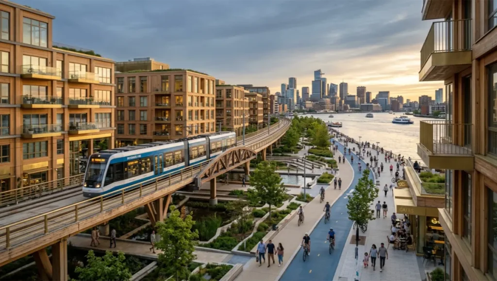
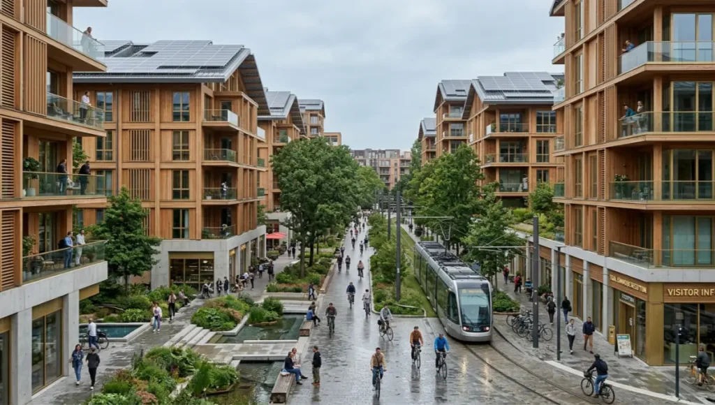
Speculative / Internal Concept Study: “Tidal Commons” by Nuvira Space
Project Overview: Location / Typology / Vision
Tidal Commons is a speculative reception district modeled for a mid-sized coastal city facing projected inbound migration from low-lying regional settlements over a 10-15 year horizon. The site is a 42-hectare brownfield waterfront parcel, currently underused light-industrial land adjacent to an existing but under-frequented commuter rail line. The typology is mixed-tenure mid-rise (4-8 storeys), mass-timber construction, organized around a central transit spine. The vision treats the district as a living absorption mechanism: capable of housing roughly 6,000 residents at initial occupancy and scaling toward 11,000 as migration pressure increases, without requiring a second master-planning cycle.
Design Levers Applied
Mobility
- Transit spine upgraded to 5-minute peak headways, funded jointly through value-capture on the rezoned brownfield parcel
- Cycling and pedestrian network connecting all residential blocks to the spine within a 7-minute walk
Infrastructure
- Segmented microgrid with rooftop solar covering an estimated 35% of district baseline demand
- Greywater recycling loop sized for the 11,000-resident scenario from day one, even at initial 6,000-resident occupancy
- Permeable ground-plane ratio of 45%, doubling as flood retention during regional surge events
Housing
- Tenure mix of 40% market-rate, 35% subsidized, 25% transitional-to-permanent units, blended within each block rather than segregated by building
- Modular unit cores allowing internal reconfiguration as household composition shifts over the absorption period
Transferable Takeaway
The core transferable principle of Tidal Commons is not the specific unit count or site geometry — it is the decision to size invisible infrastructure (water, power, transit frequency) for the upper-bound migration scenario from day one, while phasing the visible infrastructure (housing units, retail, amenities) to match actual arrival rates. This decouples the politically difficult “build for who might come” decision from the financially difficult “build for who is here now” decision, allowing each to proceed on its own defensible timeline.
The tenure-mixed, modular housing cores used in Tidal Commons draw on comparisons explored in Nuvira Space’s prefab vs. traditional social housing analysis.
2036 Future Projection
Extending current displacement trajectories a decade forward, cities that have implemented even partial versions of the blueprint above are likely to show measurably different outcomes from those that have not. Reception districts built around transit spines and pre-sized infrastructure should display occupancy curves that rise smoothly rather than in disruptive spikes, with vacancy rates in legacy housing stock remaining stable rather than collapsing under sudden demand shifts.
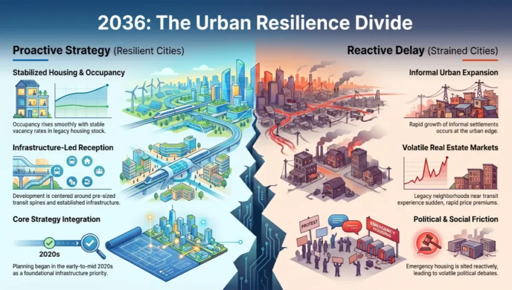
Cities that delayed action are more likely to show the opposite pattern: informal settlement growth at the urban edge, rapid premium increases in transit-adjacent legacy neighborhoods, and politically volatile debates over emergency housing sited reactively rather than planned in advance. The most resilient metropolitan regions by the mid-2030s will likely be those that began treating climate migration urban planning as core infrastructure strategy in the early-to-mid 2020s rather than as a humanitarian add-on.
Comprehensive Technical FAQ
Q: What distinguishes climate migration urban planning from standard population growth planning?
A: Standard growth planning typically assumes gradual, predictable population increase tied to economic indicators. Climate migration introduces non-linear, climate-event-triggered surges that can arrive faster than conventional permitting and infrastructure timelines can accommodate. Key distinctions include:
- Compressed timelines: months rather than years between trigger event and population arrival
- Cross-jurisdictional sourcing: arrivals often originate outside the receiving city’s normal catchment area
- Infrastructure sizing must account for overshoot scenarios, not just trend-line projections
Q: How should a transit agency size headways for a reception corridor?
A: Headways should be modeled against a range of arrival scenarios rather than a single projection. A workable approach:
- Baseline headway calibrated to current ridership
- Secondary headway tier (peak absorption) calibrated to the upper-bound migration scenario for the corridor
- Rolling stock and crew schedules designed for rapid escalation between tiers without requiring new procurement cycles
Q: What is the minimum permeable surface ratio recommended for reception districts?
A: A ratio of at least 40% is recommended for new reception districts, rising toward 45% in coastal or flood-prone sites. This figure balances flood retention capacity against achievable density, and should be verified against local hydrology studies rather than applied uniformly.
Q: How is tenure mix determined within a single residential block?
A: Tenure mix should reflect both the projected composition of incoming households and the need to avoid spatial segregation by income or migration status. A common starting ratio is roughly 40% market-rate, 35% subsidized, and 25% transitional-to-permanent, blended within buildings rather than concentrated in separate structures, though exact ratios depend on local housing subsidy frameworks.
Q: What role do microgrids play in climate migration urban planning?
A: Microgrids allow new reception districts to be energized independently of legacy substations, avoiding the lengthy upgrade cycles required to expand centralized grid capacity. Segmented microgrids with on-site generation (typically rooftop and facade solar) and battery buffering can absorb unplanned load increases of roughly 15% without triggering district-wide upgrades.
Q: How should cities approach cross-jurisdictional coordination?
A: Because climate migration flows rarely respect municipal boundaries, coordination frameworks should establish shared infrastructure funding pools, joint land-banking agreements, and harmonized permitting fast-tracks across neighboring jurisdictions. Without this, a single city’s reception district can become overwhelmed while neighboring jurisdictions remain under-utilized.
Conclusion
Climate migration urban planning is no longer a forecasting exercise — it is a design discipline with measurable inputs: transit headways, permeable surface ratios, microgrid segmentation, and tenure-mixed housing blocks. If your city’s master plan does not yet account for these variables, the gap between current capacity and future demand is widening with every planning cycle that passes. Nuvira Space works with municipal planning teams, transit agencies, and infrastructure investors to translate these principles into site-specific reception district frameworks. Review the Tidal Commons concept study, compare its design levers against your jurisdiction’s transit and infrastructure baselines, and begin scoping where a pre-sized reception corridor could sit within your existing network.
© Nuvira Space — All rights reserved. | URBAN PULSE Series | All specifications cited are based on publicly available case studies and internal modeling; no external links implied. The Tidal Commons project is a speculative internal concept study and does not represent a completed project.