

Table of Contents
Car-free city district design is no longer a Scandinavian experiment or a European curiosity. In 2026, it is a measured, replicable urban strategy — and the cities betting on it are recording quantifiable results in air quality, pedestrian fatality rates, commercial activity, and land value. This article breaks down how the model actually works, where it has been tested at scale, and what the design variables are that determine whether a car-free district thrives or stalls.
Nuvira Perspective
At Nuvira Space, we track the structural shifts reshaping cities — not as spectators, but as designers who believe the built environment is the most direct tool we have for improving how people live. Car-free city district design sits at the intersection of urban mobility, public realm quality, and long-term neighbourhood resilience. Our position: the removal of the car from the district interior is not a lifestyle statement. It is a design decision with measurable spatial, economic, and environmental consequences — and those consequences, when the design is executed correctly, are overwhelmingly positive.
The framing matters. Too much coverage of pedestrianization treats it as a political choice or an ideological preference. We treat it as an architectural and urban design problem: a question of street hierarchy, transit integration, land-use mix, freight logistics, and phased implementation. The cities that have done it well solved those design problems. The cities that have failed — and there are instructive failures — skipped steps or misread the preconditions.
What follows is our analysis of both.
The Blueprint: Design Principles for a Functional Car-Free District
The structural logic of a functional car-free district is not intuitive — and it is not simply the absence of cars. It is a precise set of design conditions that work together as a system. Remove one and the others weaken.
The Five-Minute Pedestrian Radius
The maximum viable district size is defined by a five-minute walk at a brisk pace — approximately 75 metres per minute — from any point in the district to its transit halt. This caps the district radius at roughly 375 metres. Beyond this threshold, car-free becomes car-inconvenient rather than car-unnecessary.
| Transit halt: ≤375m from any residential unitBrisk walking speed baseline: 75m/minMaximum district diameter: ~750mTransit frequency required: ≤8 min headways to compete with car convenience |
Street Hierarchy and Width Calibration
Every car-free district requires a legible street hierarchy — not as an aesthetic preference but as a functional system. It determines where cyclists travel fast, where children play safely, where freight enters, and where emergency vehicles route.
| Central boulevard: 28–32m wide — tram/BRT right-of-way + protected cycling + pedestrian promenadeSecondary residential streets: 6–8m — shared surface, cycling priority, 10 km/h design speedService alleys: 4–5m minimum — emergency vehicle clearance maintained 24/7Pedestrian-only lanes: 1.8–3m — interior courtyards and mews onlySurface treatment: no kerb separation between modes — shared space principle throughout |
Land-Use Mix at Block Scale
Mixed-use zoning at the block level — not the neighbourhood level — is the structural condition that makes the car redundant. Daily needs must be accessible within a 5–10 minute walk of any dwelling. This aligns directly with the logic of the 15-minute city concept that underpins many of these interventions.
| Ground-floor commercial mandate on all primary streets — no blank residential plinthsResidential above: 80–85% of total floor areaActive use requirement: food retail, healthcare, childcare, workspace per block clusterNo large-format retail (structurally car-dependent) permitted within district core |
Freight and Last-Mile Logistics
This is the design layer most commonly underestimated. Without a resolved freight strategy, the car-free district either fails operationally or reverts to de facto vehicle access through uncontrolled service lane use.
| Time-restricted motorised freight access: 06:00–10:00 daily onlyConsolidated logistics hub: 1 per district, co-located at transit halt for operational synergyCargo bike last-mile distribution: mandatory for all deliveries within district interiorWaste collection: vacuum pneumatic systems underground, or early-morning micro-vehiclesEmergency access: maintained on all streets ≥5m clear width — 24/7, no exceptions |
Floor Area Ratio, Density, and Public Realm Balance
The density equation is precise. Too low and the district cannot support the daily services that make car-free living viable. Too high without corresponding public realm investment creates urban density without human quality.
| Target FAR: 1.5–2.0 for residential-led mixed-use districtsBuilding coverage: 35–42% of land areaPublic realm allocation: 58–65% of land area (streets + open space)Average building height: 4–6 storeysMinimum green space ratio: 15% of district area |
Feasibility Study: Economic and Political Barriers
The design principles above are well-established. The harder question is why more districts have not implemented them. The barriers are real — and designers who engage with car-free proposals need to understand them to navigate them.
Economic Barriers
- Structured parking represents a $30,000–$50,000 per-space construction asset that developers are reluctant to strand without clear compensating value
- Retail tenants frequently cite car access as a lease condition — renegotiating at scale requires committed anchor tenant agreements in advance of opening
- First-phase economic disruption: pedestrianization creates short-term revenue uncertainty before longer-term commercial uplift is realised
- Infrastructure front-loading: transit frequency upgrades, freight hubs, and street redesign require capital expenditure before residents arrive
The counter-evidence is now substantial. Madrid’s car-free zones recorded a 9.5% increase in retail sales in pedestrianised areas versus a 3.7% decrease in non-pedestrianised zones in the same period. Pontevedra’s historic centre maintained full commercial occupancy through a 20-year pedestrianization programme. The economic case is no longer theoretical.
Political Barriers
- Incumbent parking interests — structured parking operators, surface lot owners — form effective lobbying coalitions against pedestrianization proposals
- Perception of access loss: even non-drivers frequently oppose car-free zones on behalf of hypothetical future car use
- Implementation sequencing: early phases reduce access before benefits are visible, creating political vulnerability before the programme is complete
- Equity framing: car-free districts can be perceived as elite amenities unless housing affordability is explicitly designed into the programme from the start
Oslo’s near-complete car-free downtown emerged through a disciplined sequence of pilot closures, each validated with data before the next phase was committed. The political strategy was as carefully designed as the spatial one — each phase built a coalition of beneficiaries before the next phase created new opponents.
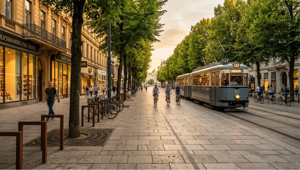
Proof of Concept: 5 Car-Free Districts That Delivered Measured Results
Barcelona, Spain — The Superblock Grid
Barcelona’s Eixample district — Ildefons Cerdà’s 1850s grid of 113-metre blocks with chamfered corners — is being reorganised into superblocks (supermanzanas): 3×3 groupings of nine standard blocks that create a pedestrian-priority interior while maintaining perimeter traffic flow for buses and through-vehicles.
| Projected noise exposure reduction: 42.5% → 26.5% of residents above 65 dB thresholdNO₂ reduction: documented on interior streets of all implemented superblocks500 streets across all 20 arrondissements targeted for traffic closureChamfered corners (Cerdà’s 1859 design decision) create plaza geometry that makes superblock public space feel spatially generous — historic grid serving contemporary car-free design |
Freiburg, Germany — The Vauban District
Built on a former French military base in the late 1990s, Vauban is Europe’s most-studied car-free residential district. The design does not prohibit car ownership — it makes car ownership structurally unnecessary through mixed-use density, transit frequency, and deliberate parking pricing.
| Car ownership: ~150 vehicles per 1,000 residents vs. 430/1,000 German national averageResidential street widths: 4–6m — shared surface with cycling priorityCentral boulevard: 28m — Straßenbahn (tram) ROW + protected cycling + pedestrianParking: consolidated at district edge, €17,000–25,000 per space — a deliberate price signalTram to Freiburg city centre: 7.5-minute frequency |
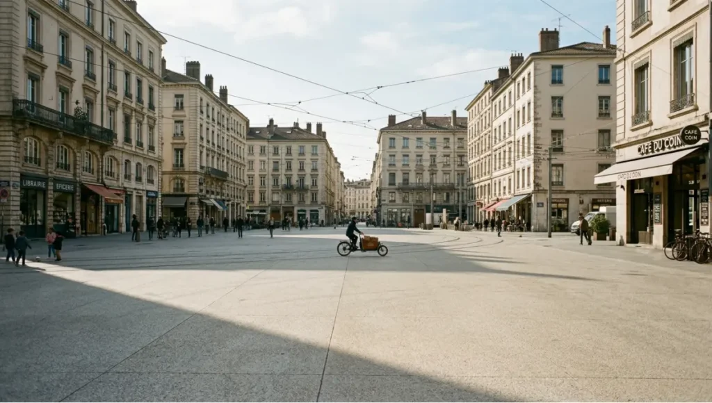
Pontevedra, Spain — The City-Scale Transformation
Pontevedra (population ~85,000) eliminated car traffic from its historic centre in 1999 — and has re-elected the mayor who implemented it continuously since. Surface parking dropped from 1,500 spaces to near zero. The intervention was blunt by design, and the outcomes are the most comprehensively documented of any car-free urban transformation.
| CO₂ emissions: ↓67% between 1996 and 2018Pedestrian fatalities in city centre: effectively zero for extended multi-year periodsRetail occupancy: stable or improved throughout the full 20+ year pedestrianization programmeProperty values in historic centre: increased post-implementation |
Shenzhen, China — NBBJ Net City
Commissioned by Tencent and masterplanned by NBBJ, Net City covers approximately 2 million m² in Shenzhen’s Nanshan District — described by NBBJ as roughly the size and shape of Midtown Manhattan. It is the largest purpose-designed car-free district in Asia, and the most significant demonstration that the model works as private development, not only as public planning.
| Three-dimensional pedestrian network: elevated walkways + ground-level plazas + underground connectionsAll vehicle infrastructure subsurface: delivery, emergency, parking — no surface vehicle accessMixed-use at block scale: campus, retail, housing, cultural facilities integrated throughoutDevelopment model: fully private — no municipal mandate required |
Tempe, USA — Culdesac Tempe
The most structurally significant proof of concept for North American designers: the first purpose-built car-free neighbourhood in US history, in the most car-dependent major metro in the country. For broader context on the urban design principles that make this viable, see our analysis of pedestrian-first city design.
| 17 acres, zero resident parking — no structured parking builtConstruction cost saving: $30,000–$50,000 per avoided parking space, reinvested in public realm qualityMobility backbone: adjacent light rail + shared e-bike/scooter fleet within districtLeased up quickly — demonstrating active market demand in a car-centric urban contextCuldesac Atlanta: next deployment, replicating model in a different US metro |
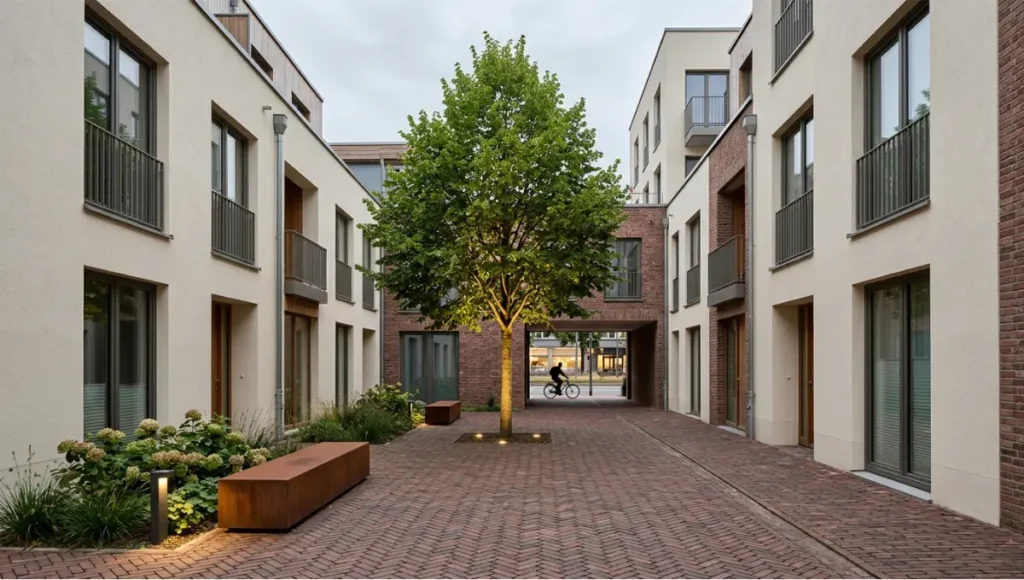
Concept Project Spotlight
Speculative / Internal Concept Study — The Layered District by Nuvira Space
This speculative design study applies the structural principles extracted from the case studies above to a hypothetical infill site. It is not a commissioned project. It is an internal design exercise — published as a demonstration of how the framework translates into design decisions at district scale.
Project Overview
Location / Context: Hypothetical inner-urban infill site, mid-sized European city, population catchment ~80,000
Typology: Residential-led mixed-use car-free district, transit-anchored, 12,000 residents
Vision: A district designed from first principles around the five-minute pedestrian radius — where the removal of car infrastructure is not a restriction but the founding spatial decision from which everything else follows.
Design Levers Applied
Transit Anchor and District Boundary
| Single tram halt at geographic centre — 7-minute frequency, 05:30–01:00 dailyDistrict radius: 375m from halt — all 12,000 residents within 5-minute walkPerimeter ring road: full vehicle access maintained — district interior car-freeTwo vehicle entry points only: freight hub (north) + emergency access routing (south) |
Street Hierarchy
| Central boulevard: 28m — tram ROW (centre) + 4m protected cycling each side + 8m pedestrian promenade each sidePrimary residential streets: 7m — shared surface, cycling priority, 10 km/h design speedCourtyard mews: 3m — pedestrian only, no cycling, no freightInterior pocket plazas: 800–1,200m² each — 1 per residential block cluster |
Building Programme and FAR
| FAR: 1.5 district averageCentral boulevard frontage: 6 storeys — mandatory active ground floor (retail, workspace, community)Residential streets: 3–4 storeys — mixed residential and ground-floor workspaceInterior courtyards: 2 storeys maximum — residential only, no commercial noiseAffordable housing: 35% of residential floor area, distributed across all typologies |
Materiality and Public Realm
| Central boulevard paving: large-format granite setts — 600×300mm, thermal-finished surfaceResidential streets: exposed aggregate concrete — warm buff tone, slip-resistant finishPedestrian mews: reclaimed brick — herringbone pattern, variable joint widthStreet furniture: weathered Corten steel — benches, cycle racks, wayfindingTree planting: 1 tree per 8m on primary streets — hornbeam double rows on boulevard, lime on residential |
Freight and Logistics Layer
| Consolidated freight hub: co-located at tram halt, north-facing vehicular entryMotorised freight access: 06:00–09:30 daily only — all other hours pedestrian-onlyLast-mile: cargo bikes exclusively within district interior after 09:30Waste: vacuum pneumatic system — underground collection, zero waste vehicles inside districtEmergency vehicle routing: central boulevard + all primary streets (≥5m clear, 24/7) |
Transferable Takeaway
The Layered District demonstrates that car-free design at residential scale is not a reduction of urban possibility — it is an expansion of it. The land freed from car storage and movement (approximately 40% of conventional street area) is redistributed as public courtyard, tree canopy, and active ground-floor programme. The district is denser in spatial experience and quieter in acoustic terms than a conventional mixed-use block of equivalent FAR.
The design lesson is transferable. The five preconditions — transit frequency, street hierarchy, mixed-use at block scale, freight resolution, and phased governance — are not location-specific. They are structural conditions applicable in any mid-to-high-density urban context with existing or planned transit infrastructure. For related analysis on urban resilience strategies, see our coverage of sponge cities and urban resilience.
2030 Future Projection: What the Trajectory Confirms
The trajectory is not speculative. The policy commitments, infrastructure investments, and development models already in place point toward a specific near-future for car-free city district design.
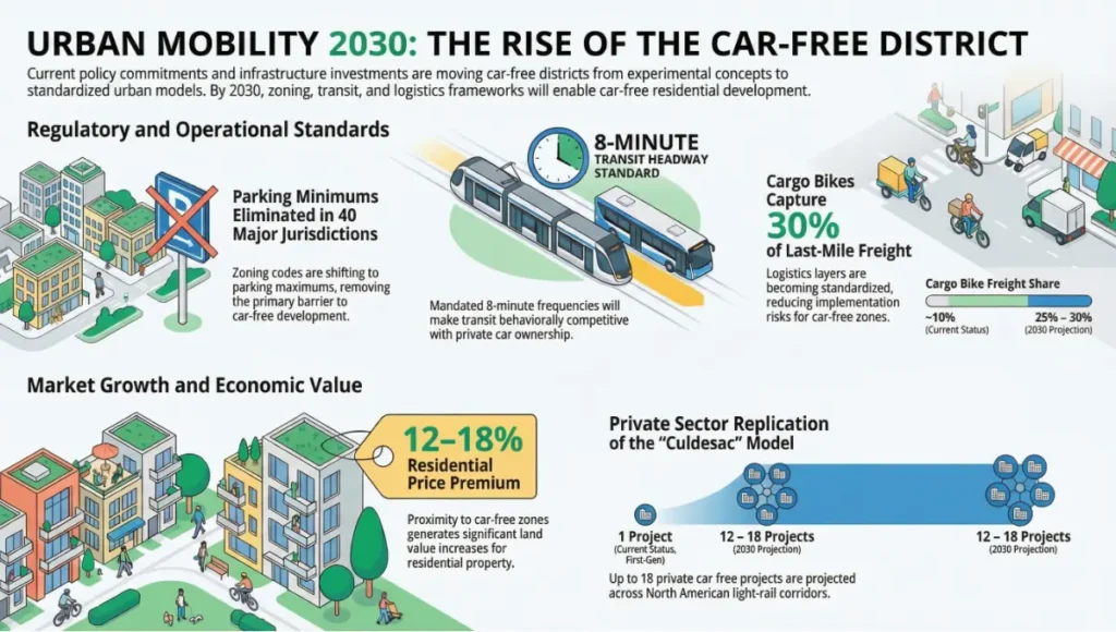
Regulatory Normalisation
By 2030, parking minimums — currently still embedded in zoning codes across most US cities and many European jurisdictions — are projected to be eliminated or inverted (converted to parking maximums) in a further 35–40 major urban jurisdictions. This removes the primary regulatory barrier to car-free residential development at scale.
Transit Frequency as Infrastructure Standard
The 8-minute headway threshold — below which transit becomes behaviourally competitive with car use — is projected to become a mandatory planning standard for new transit-adjacent development approvals in the EU by 2028 under updated SUMP (Sustainable Urban Mobility Plan) guidelines.
Cargo Bike Infrastructure at District Scale
Last-mile freight by cargo bike is projected to capture 25–30% of urban last-mile deliveries in European cities by 2030 (currently ~10%). This makes the freight logistics layer of car-free district design increasingly standardised and cost-effective — reducing one of the primary implementation risks.
Private Development Replication
The Culdesac model — car-free residential development as a private development strategy, not a public planning intervention — is projected to produce 12–18 replication projects in North American cities by 2030, concentrated in light-rail corridors in Sun Belt metros where transit infrastructure investment is accelerating.
Land Value Premium Quantification
By 2030, sufficient longitudinal data from Barcelona, Oslo, Pontevedra, and first-generation Culdesac projects will exist to quantify the land value premium attributable to car-free district status. Early indications from Oslo suggest a 12–18% residential price premium within 400m of completed car-free zones.
Comprehensive Technical FAQ
Q: What is the minimum population density required for a viable car-free district?
A: The practical minimum is approximately 80–100 residents per hectare within the district itself. Below this threshold, the district cannot support the daily commercial uses — food retail, healthcare, childcare — that make car access structurally redundant. Most successful car-free districts operate at 150–250 residents/ha.
| Minimum viable density: 80–100 residents/haOptimal density range: 150–250 residents/haFAR equivalent: 1.2–2.5 depending on building height and typology |
Q: How are emergency services accommodated without car access?
A: Emergency vehicle access is maintained on all streets with a minimum 5m clear width — which encompasses all primary and secondary streets in a correctly designed car-free district. Interior pedestrian mews (1.8–3m) are not accessible by standard emergency vehicles; this is mitigated by ensuring no residential front door is more than 40m from a 5m-wide route.
| Minimum emergency vehicle clearance: 5m on all primary and secondary streetsMaximum distance from any front door to 5m route: 40mResponse time target: no degradation vs. conventional urban layoutTram ROW: accessible to emergency vehicles in all tested implementations |
Q: What happens to residents who need cars for work or disability?
A: Car-free district design does not prohibit car ownership — it removes the assumption that every household requires on-site parking. Residents who own vehicles park at consolidated district-edge facilities. Disability access is maintained via designated accessible bays at district entries, with short-distance drop-off routing to all residential entrances.
| Accessible parking: minimum 1 bay per 25 residential units at district edgeDrop-off zone: within 50m of all residential entrancesShared car club provision: typically 1 vehicle per 20–30 car-free households reduces individual ownership needAccessible cargo bikes: available for residents with mobility equipment requirements |
Q: How does freight work at full residential scale?
A: The freight logistics model operates on three layers: a consolidated hub at the district perimeter for bulk deliveries; cargo bike distribution for last-mile within the district during restricted hours; and vacuum pneumatic or micro-vehicle waste collection for daily refuse. Time restrictions on motorised freight access keep service vehicles out of the pedestrian realm during active hours.
| Motorised freight access window: 06:00–10:00 daily onlyCargo bike last-mile: all deliveries within district interior after 10:00Hub location: co-located at transit halt — operational synergy with passenger movementLoading bay requirement: 1 per 500m² commercial floor area at hub perimeter |
Q: What is the cost differential versus conventional mixed-use development?
A: Car-free districts eliminate structured parking construction costs — a significant per-unit saving for developers. This is partially offset by higher public realm investment and freight infrastructure. Net development cost is typically 5–12% lower per residential unit than equivalent conventional mixed-use development with structured parking.
| Structured parking cost avoided: $30,000–$50,000/space (US); €15,000–35,000 (EU)Public realm premium over conventional layout: +8–15% of site development costFreight infrastructure capital: €200,000–800,000 per district depending on scaleNet per-unit saving vs. equivalent conventional development: 5–12% |
Q: Can car-free districts be retrofitted into existing urban fabric?
A: Yes — and the most instructive examples are retrofits, not blank-canvas projects. Barcelona’s superblocks, Pontevedra’s historic centre, and Oslo’s city centre are all retrofits of existing urban fabric. The design sequence for retrofit differs from greenfield: it begins with reversible temporary closures and progresses through semi-permanent to permanent redesign, with data collection at each phase.
| Phase 1 Pilot: temporary closures, 3–6 months — fully reversible, low capital costPhase 2 Interim: semi-permanent bollards, planting, pop-up programming — 12–24 monthsPhase 3 Permanent: full street redesign, paving, freight infrastructure — 24–48 monthsData collection and public review required at each phase gate before proceeding |
The Design Is Ready. Is the Implementation Strategy?
Car-free city district design in 2026 is a solved design problem — in the sense that the structural conditions for success are documented, tested, and transferable. What remains is the harder work: applying those conditions to specific sites, navigating the economic and political barriers, and designing the phased implementation that allows a transformation of this scale to complete without losing momentum.
The five cases examined in this article are not outliers. They are the leading edge of a structural shift that is now accelerating across urban planning agendas worldwide. The design principles they validate are consistent: five-minute pedestrian radii, calibrated street hierarchies, mixed-use at block scale, resolved freight logistics, and phased governance frameworks.
What 2026 confirms is that the question is no longer whether car-free city district design works. The tested cases have answered that. The question now is how to design it well, how to phase its implementation within existing urban fabric, and how to build the political and institutional continuity that allows a transformation of this scale to complete.
At Nuvira Space, we publish the analysis, case studies, and speculative design work that keeps architects, urban designers, and developers at the leading edge of this shift. If car-free district design is relevant to your current project, practice, or city — the frameworks in this article are your starting point. The five cases above are your proof.